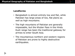
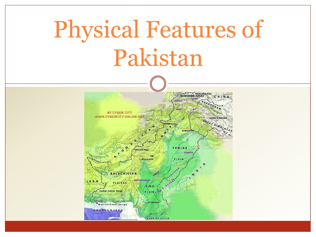
Physical Geography of Pakistan: Mountains, Plains, Plateaus, and Deserts


Physical Features
of
Pakistan
Satellite
view
of South
Asia
Political Map
of
Pakistan
Neighbors of
Pakistan
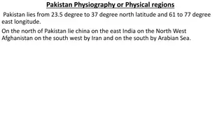
Coordinates:
Latitude:
24
°
N -
37
°
N
Longitude:
61
°
E
-
75.5
°
E
Total
Area:
796,096
sq
km
Altitude:
Highest
point:
K-2
(8611m)
Deepest
point:
Dasu patan
(6500m)
Lowest
point:
Sea level 0
(feet)
Immediate
Neighbor
Countries
C
o
u
n
tri
es
Direc
t
i
o
n
Length
of
border
(Km)
China
North
592
In
d
ia
East
1600
Arabian
Sea
S
o
uth
1000
Iran
South
West
850
Afghanistan
W
e
s
t
2250
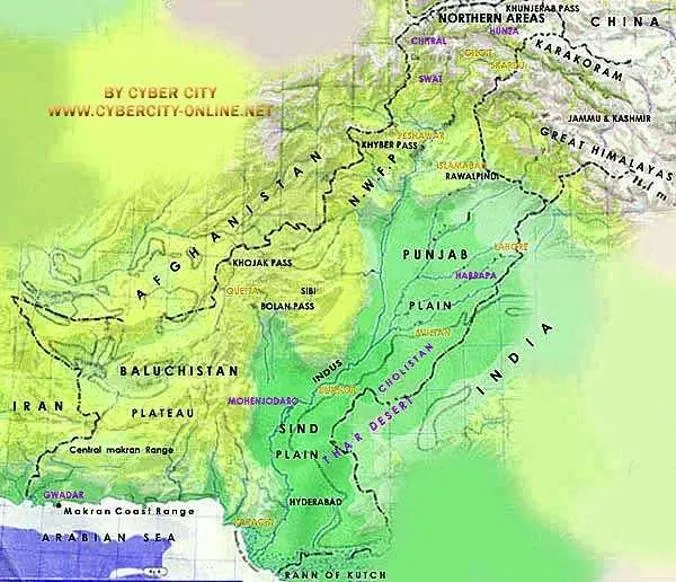
Physical Map
of
Pakistan
Physical Division
of
Pakistan
Generally
We
can classify the Pakistan
into
Four
Major Physical
provinces
which
are:
1.
Mountains
2.
Plains
3.
Plateaus
4.
Deserts
Mountains
There
are
three
distinct Mountain
ranges
•
Northern
Mountains
o
Karakoram
Ranges
o
Himalaya
Ranges
o
Greater
Himalayas
o
Lesser
Himalayas
o
Siwaliks
•
North
Western
Mountains
o
Hindukush
•
Western
Mountains
o
Safed Koh
Ranges
o
Waziristan
Hills
o
Suleman and Kirthar
Range
Northern
Mountains
Sub
Himalayas
Height:
600-1200
meter
Great Himalayas
Height:
more
than
4600
meter
Lesser
Himalayas
Height:
1800-4600
meter
Himalayas:
Northern
Mountains
Karakorum:
Average
height
is
about
6100 meter
Goodwin
Austin
(K-2)
2
nd
highest
peak
North
Western
Mountains
Hindu
Kush Mountains:
Originates from Pamir
plateau.
highest
peaks are
Noshaq (7369
m) and
Tirch
mir
(7690
m)
lies
in
the west of Himalaya
and
karakorum
Western
Highlands
Western highland comprises of the following three
mountain
ranges.
1.
The
koh-e-sofaid
ranges:
1.
Average
height
is about 3600
m
2.
Highest
peak
is
Sikaram
(4700
m)
3.
Located in
East-West
Direction
4.
Kurram
and
Kohat
valley
lies
in
this
range.
Western
Highlands
Waziristan
hills:
1.
Located between
Gomal
and
Kurram
river.
2.
Its Height ranges
from
1500 - 3000
meter.
3.
These
range forms the border between Afghanistan
and
Pakistan
4.
Famous Khyber pass lies
in
this
Range.
Western
Highlands
The Suleman and
Kirthar
Ranges:
1.
2.
3.
4.
5.
6.
Starts
from
South of
Gomal
River
Lies
between
the
Baluchistan plateau and
the
Indus river.
Average
height
is about 600
m.
Takht-e-Suleman is
the highest point
(3487
m)
In south The Suleman joins the kirthar
range.
And
Kirthar
merges into
the
kohistan area
of
Sindh.
The
Suleman and Kirthar
Ranges:
Here We
can
see
the Releif
of
Suleman and
Kirthar
range
The Indus
Plains
The Indus
Plains
The Whole Indus plain
comprises the
20%
of the
Pakistan.
We
can
divide it into
three
parts;
1.
Upper Indus
Plain
2.
Lower Indus
Plain
3.
Deltaic
Plain
The Indus
Plains
The Upper Indus
Plains:
Extends from
Attock
to Mithan
kot.
Jhelum, Chenab,
Ravi and Sutlej
are the Eastern tributaries of
river
Indus.
The
area
between
the
two tributaries is called
Doab.
All the
tributaries
meet at
the point called
Panjnad.
The Indus
Plains
The Indus
Plains
The Lower Indus
Plains:
It
extends from
Mithan
kot
to
Thatta.
This is
the
old
stage
of river
Indus.
Due to the very less
gradient
speed
of
Indus is very
slow.
The Indus
Plains
The
Deltaic
Plain:
Total
length
is
1000
km
•
While 700 Km lies
in
Baluchistan
•
And about 300 km
lies
in
Sind.
Thatta and Badin
districts
in
Sind.\
Mangrove forests are the significant feature of the
Sind Deltaic
plain.
The coastal
area lies in Baluchistan is
called makran coastal
plain.
Deserts of
Pakistan
Deserts in
Pakistan
Thar
Thal
Cholistan
Kharan
Deserts of
Pakistan
Thar
Desert:
This
desert lies
in
the South east
of
Pakistan.
This
desert
is the
extension
of
Rajasthan desert
of
India.
The
Sectio
n
o
f
th
i
s
d
e
ser
t
situat
e
d
in
th
e Bahawalpur
div
i
si
o
n
is
called
Cholistan.
Deserts of
Pakistan
Thal
Desert:
Thal
desert lies between the
River
Indus
and
Jhelum.
Kharan
Desert:
The
Kharan desert located
in the
North west
Baluchistan.
The average rainfall
is
less than
100
mm.
The
Plateaus of
Pakistan
Plateaus of
Pakistan
B
a
luc
h
ist
a
n
Plateau
Potowar
Plateau
and
Salt
Range
The
Plateaus of
Pakistan
The
Baluchistan
Plateau:
Located
in
Southwest
of
Pakistan.
Average
height
is
about
300 – 600
meters.
Very rich in
mineral
resources.
Scanty
Rain
fall.
Inland
drainage.
The
Plateaus of
Pakistan
The Potwar Plateau & The
Salt
Range:
1.
2.
3.
4.
5.
6.
Located between River Indus & River
Jhelum
Height 300 to 600
meters
from
sea
level.
Soan River is
main
river.
It
forms
gullies and
large
alluvial
plains,
mainly
used for
agriculture.
Rich in
minerals
like rock salt,
gypsum, lime
stone,
coal,
marble,
clays,
dolomite
&
soapstone
and
oil.
While
average height of Salt range is
750
to
900m.
Sakesar
Peak
is
the highest point in the Salt Range at
a
height of
1527m.
Thank
You
Source:-
linkedin/slideshare
Pakistan's diverse physical features include towering mountains like the Karakoram and Himalayas, expansive plains, elevated plateaus, and vast deserts. The country shares borders with China, India, Iran, Afghanistan, and the Arabian Sea. The Northern Mountains consist of distinct ranges like the Karakoram, Hindu Kush, and Safed Koh, each with unique characteristics. The Great Himalayas, Lesser Himalayas, and Sub-Himalayas dominate the landscape, with peaks like K-2 making their mark. Explore Pakistan's rich physical divisions and topographical wonders.

Download Presentation

Please find below an Image/Link to download the presentation.
The content on the website is provided AS IS for your information and personal use only. It may not be sold, licensed, or shared on other websites without obtaining consent from the author. Download presentation by click this link. If you encounter any issues during the download, it is possible that the publisher has removed the file from their server.
E N D
Presentation Transcript
Physical Features of Pakistan
Neighbors of Pakistan Coordinates: Latitude: 24 N - 37 N Longitude: 61 E - 75.5 E TotalArea: 796,096 sq km Altitude: Highest point: K-2 (8611m) Deepest point: Dasu patan (6500m) Lowest point: Sea level 0 (feet)
Immediate Neighbor Countries Countries Direction Length of border (Km) 592 1600 1000 850 2250 China India North East South SouthWest West Arabian Sea Iran Afghanistan
Physical Division of Pakistan Generally We can classify the Pakistan into Four Major Physical provinces which are: Mountains 2. Plains 3. Plateaus 4. Deserts 1.
Mountains There are three distinct Mountain ranges Northern Mountains Karakoram Ranges Himalaya Ranges o GreaterHimalayas o LesserHimalayas o Siwaliks North Western Mountains Hindukush Western Mountains Safed Koh Ranges Waziristan Hills Suleman and Kirthar Range o o o o o o
Northern Mountains Himalayas: Sub Himalayas Height: 600-1200 meter Lesser Himalayas Height: 1800-4600 meter Great Himalayas Height: more than 4600 meter
Northern Mountains Karakorum: Average height is about 6100 meter Goodwin Austin (K-2) 2nd highestpeak
North Western Mountains Hindu Kush Mountains: Originates from Pamir plateau. highest peaks are Noshaq (7369 m) and Tirch mir (7690 m) lies in the west of Himalaya and karakorum
Western Highlands Western highland comprises of the following three mountain ranges. The koh-e-sofaid ranges: Average height is about 3600 m Highest peak is Sikaram (4700 m) Located in East-West Direction Kurram and Kohat valley lies in this range. 1. 1. 2. 3. 4.
Western Highlands Waziristan hills: Located between Gomal and Kurram river. 2. Its Height ranges from 1500 - 3000 meter. 3. These range forms the border between Afghanistan and Pakistan 4. Famous Khyber pass lies in this Range. 1.
Western Highlands The Suleman and Kirthar Ranges: Starts from South of Gomal River Lies between the Baluchistan plateau and the Indus river. Average height is about 600 m. Takht-e-Suleman is the highest point (3487 m) In south The Suleman joins the kirthar range. And Kirthar merges into the kohistan area of Sindh. 1. 2. 3. 4. 5. 6.
The Suleman and Kirthar Ranges: Here We can see the Releif of Suleman and Kirthar range
The Indus Plains The Whole Indus plain comprises the 20% of the Pakistan. We can divide it into three parts; 1. Upper Indus Plain 2. Lower Indus Plain 3. Deltaic Plain
The Indus Plains The Upper Indus Plains: Extends from Attock to Mithan kot. Jhelum, Chenab, Ravi and Sutlej are the Eastern tributaries of river Indus. The area between the two tributaries is called Doab. All the tributaries meet at the point called Panjnad. Name of Doab Bari Doab Rachna Doab Chaj Doab Name of Rivers River Beas & River Ravi River Ravi & River Chenab River Chenab & River Jhelum River Jhelum & River Indus Sindh Sagar Doab
The Indus Plains The Lower Indus Plains: It extends from Mithan kot to Thatta. This is the old stage of river Indus. Due to the very less gradient speed of Indus is very slow.
The Indus Plains The Deltaic Plain: Total length is 1000 km While 700 Km lies in Baluchistan And about 300 km lies in Sind. Thatta and Badin districts in Sind.\ Mangrove forests are the significant feature of the Sind Deltaic plain. The coastal area lies in Baluchistan is called makran coastal plain.
Deserts of Pakistan Deserts in Pakistan Thar Thal Kharan Cholistan
Deserts of Pakistan Thar Desert: This desert lies in the South east of Pakistan. This desert is the extension of Rajasthan desert of India. The Section of this desert situated in the Bahawalpur division is called Cholistan.
Deserts of Pakistan Thal Desert: Thal desert lies between the River Indus and Jhelum. Kharan Desert: The Kharan desert located in the North west Baluchistan. The average rainfall is less than 100 mm.
The Plateaus of Pakistan Plateaus of Pakistan Baluchistan Plateau Potowar Plateau and Salt Range
The Plateaus of Pakistan The Baluchistan Plateau: Located in Southwest of Pakistan. Average height is about 300 600 meters. Very rich in mineral resources. Scanty Rain fall. Inland drainage.
The Plateaus of Pakistan The Potwar Plateau & The Salt Range: Located between River Indus & RiverJhelum Height 300 to 600 meters from sea level. Soan River is main river. It forms gullies and large alluvial plains, mainly used for agriculture. Rich in minerals like rock salt, gypsum, lime stone,coal, marble, clays, dolomite & soapstone and oil. While average height of Salt range is 750 to 900m. Sakesar Peak is the highest point in the Salt Range ata height of 1527m. 1. 2. 3. 4. 5. 6.
Thank You Source:- linkedin/slideshare