Geography and Boundaries of India
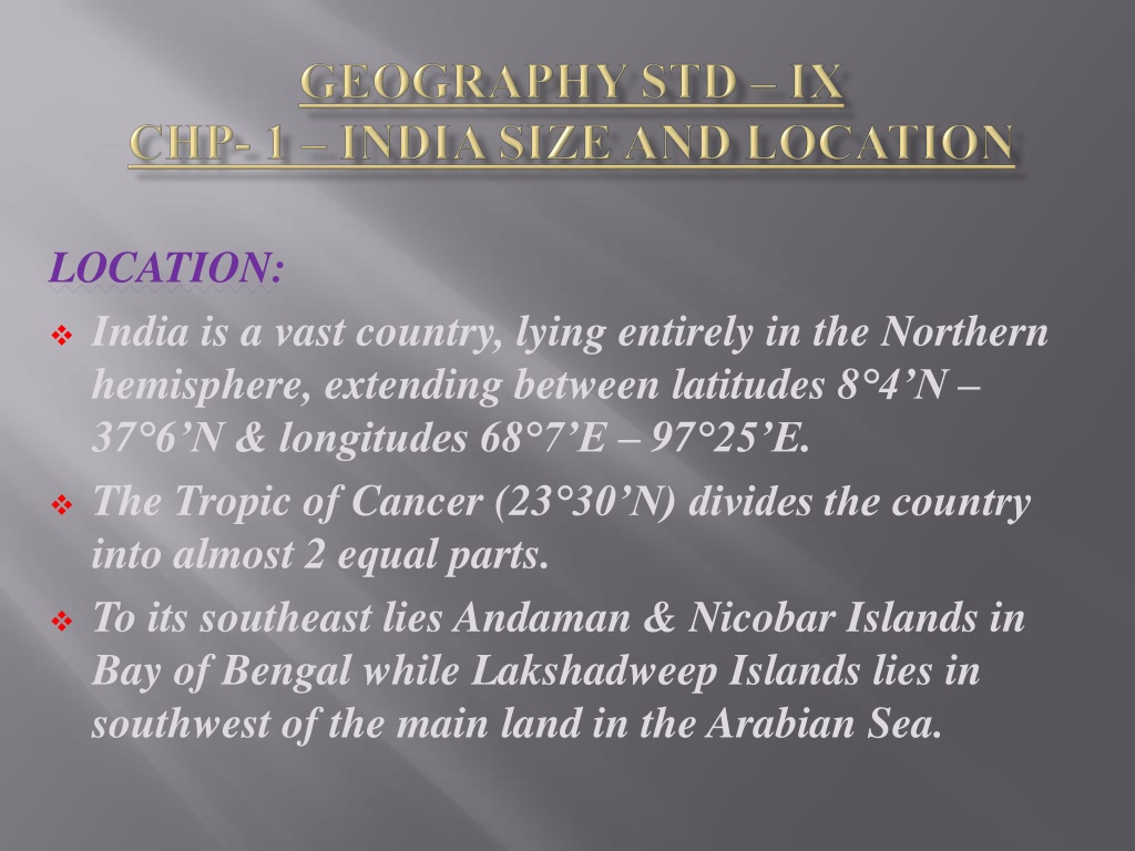
LOCATION
:
India is a vast country, lying entirely in the Northern
hemisphere, extending between latitudes 8°4’N –
37°6’N & longitudes 68°7’E – 97°25’E.
The Tropic of Cancer (23°30’N) divides the country
into almost 2 equal parts.
To its southeast lies Andaman & Nicobar Islands in
Bay of Bengal while Lakshadweep Islands lies in
southwest of the main land in the Arabian Sea.
SIZE
:
India has an area of 3.28 million sq kms which accounts
for about 2.4% of the total geographical area of the
world.
It has a land boundary of about 15,200 kms & the total
length of the coastline of the main land including
Andaman & Nicobar and Lakshadweep is 7516.6 kms.
It is bounded by young fold mountains in the north-
west, north & north-east.
Towards south, it tapers & extends towards the Indian
Ocean dividing it into two seas, the Arabian Sea on the
west & the Bay of Bengal on its east.
From Gujarat to Arunachal Pradesh, there is a time lag
of 2 hours.Thus, the Standard Meridian of India-
82°30’E is taken for calculating time.
INDIA & THE WORLD
:
Indian landmass has a central location between the
east & west Asia. It is the southward extension of the
Asian continent which helps in connecting the
countries of Europe in the west & the countries of
east Asia by the trans Indian Ocean routes giving it a
strategic central location.
Due to the protrusion of Deccan Peninsula into the
Indian Ocean, it establishes a close contact with West
Asia, Africa & Europe from the west coast & south-
east & East Asia from the eastern coast.
Due to India’s eminent position in the Indian Ocean,
it justifies the name of the ocean as Indian Ocean.
Various passes across the mountains in the north
have provided passages to the ancient travelers, while
oceans restricted such interaction for a long time.
These routes have contributed in the exchange of
ideas & commodities.
The ideas of Upanishads & Ramayan, the stories of
Panchatantra, the Indian numerals & the decimal
systems, thus could reach many parts of the world.
The spices, muslin & other merchandise were taken
from India to different countries.
Influence of Greek sculpture & the architectural
styles of dome & minarets from West Asia can be seen
in different parts of our country.
GRAPHICAL REPRESENTATION OF SEVEN
LARGEST COUNTRIES OF THE WORLD
INDIA’S NEIGHBOURS
:
India has 28 states & 8 union territories.
It shares its land boundaries with Pakistan &
Afghanistan in the north-west, China (Tibet), Nepal
& Bhutan
in the north & Myanmar and Bangladesh
in the east.
Our southern neighbors across the sea consist of 2
island countries – Sri Lanka & Maldives.
Sri Lanka is separated from India by a narrow
channel of sea formed by Palk Strait & Gulf of
Mannar while Maldives Islands are situated to the
south of the Lakshadweep Islands.
1.
Write the names of present states & union
territories of India with their capitals.
2.
On the political map of India, mark the
states and capitals using different colours.
***********
India, a vast country in the Northern hemisphere, is divided by the Tropic of Cancer into two almost equal parts. With an area of 3.28 million sq kms, it has a strategic central location connecting West Asia, Africa, Europe, and East Asia. India's landmass, with its diverse terrain and long coastline, has facilitated historical trade routes and cultural exchanges. It shares land boundaries with several neighboring countries.

Download Presentation

Please find below an Image/Link to download the presentation.
The content on the website is provided AS IS for your information and personal use only. It may not be sold, licensed, or shared on other websites without obtaining consent from the author.If you encounter any issues during the download, it is possible that the publisher has removed the file from their server.
You are allowed to download the files provided on this website for personal or commercial use, subject to the condition that they are used lawfully. All files are the property of their respective owners.
The content on the website is provided AS IS for your information and personal use only. It may not be sold, licensed, or shared on other websites without obtaining consent from the author.
E N D
Presentation Transcript
LOCATION: India is a vast country, lying entirely in the Northern hemisphere, extending between latitudes 8 4 N 37 6 N & longitudes 68 7 E 97 25 E. The Tropic of Cancer (23 30 N) divides the country into almost 2 equal parts. To its southeast lies Andaman & Nicobar Islands in Bay of Bengal while Lakshadweep Islands lies in southwest of the main land in the Arabian Sea.
SIZE: India has an area of 3.28 million sq kms which accounts for about 2.4% of the total geographical area of the world. It has a land boundary of about 15,200 kms & the total length of the coastline of the main land including Andaman & Nicobar and Lakshadweep is 7516.6 kms. It is bounded by young fold mountains in the north- west, north & north-east. Towards south, it tapers & extends towards the Indian Ocean dividing it into two seas, the Arabian Sea on the west & the Bay of Bengal on its east. From Gujarat to Arunachal Pradesh, there is a time lag of 2 hours.Thus, the Standard Meridian of India- 82 30 E is taken for calculating time.
INDIA & THE WORLD: Indian landmass has a central location between the east & west Asia. It is the southward extension of the Asian continent which helps in connecting the countries of Europe in the west & the countries of east Asia by the trans Indian Ocean routes giving it a strategic central location. Due to the protrusion of Deccan Peninsula into the Indian Ocean, it establishes a close contact with West Asia, Africa & Europe from the west coast & south- east & East Asia from the eastern coast. Due to India s eminent position in the Indian Ocean, it justifies the name of the ocean as Indian Ocean.
Various passes across the mountains in the north have provided passages to the ancient travelers, while oceans restricted such interaction for a long time. These routes have contributed in the exchange of ideas & commodities. The ideas of Upanishads & Ramayan, the stories of Panchatantra, the Indian numerals & the decimal systems, thus could reach many parts of the world. The spices, muslin & other merchandise were taken from India to different countries. Influence of Greek sculpture & the architectural styles of dome & minarets from West Asia can be seen in different parts of our country.
GRAPHICAL REPRESENTATION OF SEVEN LARGEST COUNTRIES OF THE WORLD
INDIAS NEIGHBOURS: India has 28 states & 8 union territories. It shares its land boundaries with Pakistan & Afghanistan in the north-west, China (Tibet), Nepal & Bhutan in the north & Myanmar and Bangladesh in the east. Our southern neighbors across the sea consist of 2 island countries Sri Lanka & Maldives. Sri Lanka is separated from India by a narrow channel of sea formed by Palk Strait & Gulf of Mannar while Maldives Islands are situated to the south of the Lakshadweep Islands.
Write the names of present states & union territories of India with their capitals. 1. On the political map of India, mark the states and capitals using different colours. 2. ***********