Enhancing Subseasonal-to-Seasonal Forecasting with S2S Database Archiving
Explore the contributions of key centers like ECMWF, ECCC, UKMO, and others to the S2S database archiving, detailing the models, data providers, and current status. Learn about plans to add new variables, extend access to researchers, and integrate ocean data into the MARS system for enhanced forecasting capabilities.
Download Presentation

Please find below an Image/Link to download the presentation.
The content on the website is provided AS IS for your information and personal use only. It may not be sold, licensed, or shared on other websites without obtaining consent from the author.If you encounter any issues during the download, it is possible that the publisher has removed the file from their server.
You are allowed to download the files provided on this website for personal or commercial use, subject to the condition that they are used lawfully. All files are the property of their respective owners.
The content on the website is provided AS IS for your information and personal use only. It may not be sold, licensed, or shared on other websites without obtaining consent from the author.
E N D
Presentation Transcript
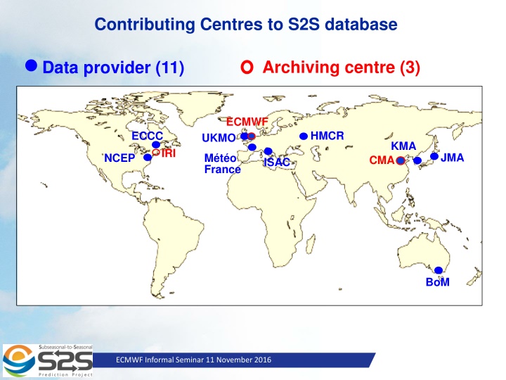
Contributing Centres to S2S database Archiving centre (3) Data provider (11) ECMWF HMCR ECCC UKMO KMA IRI JMA M t o France NCEP CMA ISAC BoM Slide 1 ECMWF Informal Seminar 11 November 2016
S2S Models Time- range Resol. Ens. Size Freq. Hcsts Hcst length Hcst Freq Hcst Size ECMWF D 0-46 T639/319L91 51 2/week On the fly Past 20y 2/weekly 11 UKMO D 0-60 N216L85 4 daily On the fly 1993-2015 4/month 3 NCEP D 0-44 N126L64 4 4/daily Fix 1999-2010 4/daily 1 ECCC D 0-32 0.45x0.45 L40 21 weekly On the fly 1995-2014 weekly 4 BoM D 0-60 T47L17 33 2/weekly Fix 1981-2013 6/month 33 JMA D 0-34 T319L60 25 2/weekly Fix 1981-2010 3/month 5 KMA D 0-60 N216L85 4 daily On the fly 1996-2009 4/month 3 CMA D 0-45 T106L40 4 daily Fix 1886-2014 daily 4 CNRM D 0-32 T255L91 51 weekly Fix 1993-2014 2/monthly 15 CNR-ISAC D 0-32 0.75x0.56 L54 40 weekly Fix 1981-2010 6/month 1 HMCR D 0-63 1.1x1.4 L28 20 weekly Fix 1981-2010 weekly 10 Slide 2 ECMWF Informal Seminar 11 November 2016
S2S models Models Ocean coupling Active Sea Ice ECMWF YES YES UKMO YES YES NCEP YES YES ECCC NO NO BoM YES Planned JMA NO NO KMA YES YES CMA YES YES CNRM YES YES ISA-CNR NO NO HMCR NO NO Slide 3 ECMWF Informal Seminar 11 November 2016
S2S Database current status Open access to researchers since May 2015 from ECMWF and Nov. 2015 from CMA. Subset of the database also available in netcdf from IRI data library. Currently, data from all centres except KMA (will become available soon) are available. Total size of the database so far: 43 Tbytes - real-time: 7 Tbytes - re-forecasts: 36 Tbytes Plans End of 2016: all 11 Data Providers Add new ocean sub-surface and sea-ice variables Compute and archive indices such as MJO RMMs, SSW index, Weather regimes, Tropical storm tracks, Monsoon indices to be available for the research community from ECMWF and IRI servers. Slide 4 ECMWF Informal Seminar 11 November 2016
New variables to be added Atmosphere: Vertical Velocity (currently archived at 500 hPa only) to be archived in all pressure levels: from 1st January 2017 in some S2S models Ocean/sea-ice variables: Sea surface salinity Depth of 20 deg isoth Mixed layer depth Heat content at top 300m Salinity in top 300m U surface current V surface current Sea surface height Sea ice thickness These new variables will be archived in netcdf in MARS. Work is ongoing to archive ocean data in the MARS system (project for ERA-CLIM2). New variables will not be ready for all the S2S models straight away. For models with fixed climatology, we may need to wait the next version of these model. Slide 5 ECMWF Informal Seminar 11 November 2016
ECMWF S2S website: s2s.ecmwf.int CMA website: s2s.cma.cn Slide 6 ECMWF Informal Seminar 11 November 2016 http://apps.ecmwf.int/datasets/data/s2s
Use of the S2S database 600 registered users from 65 countries at ECMWF 140 register users mostly from China at CMA ECMWF Server Slide 7 ECMWF Informal Seminar 11 November 2016
BAMS article on S2S database to be published in Jan 2017 Slide 8 ECMWF Informal Seminar 11 November 2016 October 29, 2014
S2S model documentation Slide 9 ECMWF Informal Seminar 11 November 2016 October 29, 2014
Initialization of land surface Documentation A questionnaire has been produced by GEWEX/GLASS The S2S Project Office has sent the questionnaire to 11 the data providers So far 9 have replied, and the soil initialization documentation is now included in their model documentation in the ECMWF S2S website. Have not replied yet: NCEP and HMCR Slide 10 ECMWF Informal Seminar 11 November 2016 October 29, 2014
Questionnaire on Land ICs 1. What is the land surface model (LSM) and version used in the forecast model, and what are the current/relevant references for the model? Are there any significant changes/deviations in the operational version of the LSM from the documentation of the LSM? 2. How is soil moisture initialized in the forecasts? (climatology / realistic / other) If climatology , what is the source of the climatology? If realistic , does the soil moisture come from an analysis using the same LSM as is coupled to the GCM for forecasts, or another source? Please describe the process of soil moisture initialization. If other , please describe the process of soil moisture initialization. Is there horizontal and/or vertical interpolation of initialization data onto the forecast model grid? If so, please give original data resolution(s). Does the LSM differentiate between liquid and ice content of the soil? If so, how are each initialized? If all model soil layers are not initialized in the same way or from the same source, please describe. 3. How is snow initialized in the forecasts? (climatology / realistic / other) If climatology , what is the source of the climatology? If realistic , does the snow come from an analysis using the same LSM as is coupled to the GCM for forecasts, or another source? Please describe the process of soil moisture initialization. If other , please describe the process of soil moisture initialization. Is there horizontal and/or vertical interpolation of data onto the forecast model grid? If so, please give original data resolution(s) Are snow mass, snow depth or both initialized? What about snow age, albedo, or other snow properties? 4. How is soil temperature initialized in the forecasts? (climatology / realistic / other) If climatology , what is the source of the climatology? If realistic , does the soil moisture come from an analysis using the same LSM as is coupled to the GCM for forecasts, or another source? Please describe the process of soil moisture initialization. If other , please describe the process of soil moisture initialization. Is the soil temperature initialized consistently with soil moisture (frozen soil water where soil temperature 0 cover (top layer soil temperature 0 C under snow)? Is there horizontal and/or vertical interpolation of data onto the forecast model grid? If so, please give original data resolution(s) If all model soil layers are not initialized in the same way or from the same source, please describe. C) and snow Slide 11 ECMWF Informal Seminar 11 November 2016 October 29, 2014
