Enhancing Earthwork Volumetric Calculations with UAV Technology
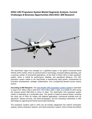
Explore the comparative study on utilizing Unmanned Aerial Vehicles (UAVs) for earthwork volumetrics in engineering applications. Discover the benefits, global interests, reasons for UAV popularity, civilian applications, and the evolution of technology in this field. Streamline volumetric calculations and improve efficiency with UAV solutions.
Download Presentation

Please find below an Image/Link to download the presentation.
The content on the website is provided AS IS for your information and personal use only. It may not be sold, licensed, or shared on other websites without obtaining consent from the author.If you encounter any issues during the download, it is possible that the publisher has removed the file from their server.
You are allowed to download the files provided on this website for personal or commercial use, subject to the condition that they are used lawfully. All files are the property of their respective owners.
The content on the website is provided AS IS for your information and personal use only. It may not be sold, licensed, or shared on other websites without obtaining consent from the author.
E N D
Presentation Transcript
Earthwork Volumetrics with Unmanned Aerial Vehicles A Comparative Study Raid Al-Tahir and Travis Barran Geomatics Engineering and Land Management, The University of the West Indies, Trinidad and Tobago IConETech-2020, Faculty of Engineering, The UWI, St. Augustine, Trinidad and Tobago
Unmanned Aerial Vehicles UAV is an aircraft operated with no pilot on board Navigates manually, semi- or fully autonomous Commonly referred to as: UAV (Unmanned Aerial Vehicle) UAS (Unmanned Aerial System) RPAS (Remotely Piloted Aircraft System) sUAV (Small UAV) Drone UAS comprises of 3 or more main features: Unmanned Aircraft / Air Vehicle Command and Control Link/ Data Link Ground Control Station IConETech-2020, Faculty of Engineering, The UWI, St. Augustine, Trinidad and Tobago
Global Interests in the UAV UAVs have been around since the mid 1900s Over the past decade; UAVs have become more widely used in civilian operations UAV production has doubled and kept growing Enhanced performance, payload, endurance and flexibility Evolution of technology GNSS, gyroscopes, cameras Development of algorithms for processing UAV images IConETech-2020, Faculty of Engineering, The UWI, St. Augustine, Trinidad and Tobago
Some Reasons for the Popularity of UAV Cost effective option and a return on investment. Portable, easy to use, and customizable. Quick deployment, data collection and data retrieval. Use in high risk situations and inaccessible areas Removing humans from dangerous locations Minimise disruption of working site Trucks and plant work uninterrupted Less chance for site accidents IConETech-2020, Faculty of Engineering, The UWI, St. Augustine, Trinidad and Tobago
Some Civilian Applications IConETech-2020, Faculty of Engineering, The UWI, St. Augustine, Trinidad and Tobago
Earthwork Volumetric Calculations Obtaining volumetric data for earthworks is an important task in many engineering disciplines Highway/road construction, mining industry, .. Currently used methods consists of: Perform a topographic survey Create two surfaces for before and after the earthwork activity, Subtract one surface from the other to obtain the volume of material excavated or filled. The volume measurements as traditionally executed Use Total Station surveys, Global positioning system (RTK) Labour intensive and fairly time consuming. IConETech-2020, Faculty of Engineering, The UWI, St. Augustine, Trinidad and Tobago
UAV Photogrammetry for Volume Calculations The constant advancements in UAV systems and automated photogrammetric software have made attaining geospatial data more cost effective and less time consuming. The evolution of UAVs as measuring instruments has become attractive for many surveying applications in civil engineering. The purpose of this investigation is to analyse the performance of UAV systems in acquiring 3D mapping data for earthmoving construction sites. compare and assess the feasibility of UAV surveying to that of Total Station surveying. IConETech-2020, Faculty of Engineering, The UWI, St. Augustine, Trinidad and Tobago
Test Area Test area: A segment of the Churchill Roosevelt Highway Extension to Manzanilla (CRHEM) East of the Cumoto road and passing through the Forest reserve Along the west bound lane of the highway from chainages 7+380 to 7+460 (80 meters). Width of the road section is 17.45 meters. The finished sub grade level Thickness of the subbase layer IConETech-2020, Faculty of Engineering, The UWI, St. Augustine, Trinidad and Tobago
Data Acquisition and Pre-processing Reconnaissance and Flight Planning Establishing Ground Control Points 9 GCPs for first flight along the road 6 GCPs for the second mission Acquisition of UAV Imagery 159 vertical images in the first flight 34 images in the second flight Processing of UAV Imagery with Agisoft Photoscan Professional A dense point cloud was generated: 3,889,801 points for the subgrade 19,772,696 points for the subbase IConETech-2020, Faculty of Engineering, The UWI, St. Augustine, Trinidad and Tobago
Generating TIN Surfaces Total Station-based surfaces 27 points for the subgrade; 25 points for subbase surfaces. UAV-surface from point cloud Point cloud was first filtered into 118,364 points A point in every 15 cm ~4000 points between 4 TS points. IConETech-2020, Faculty of Engineering, The UWI, St. Augustine, Trinidad and Tobago
Accuracy of UAV-Surfaces vs. Total Stations RMSE based on GCP: Subgrade model: 0.018m in XY; 0.008m in Z Subbase model: 0.03m in XY; 0.004m in Z Point to Surface Comparison Average Error: 0.04m RMS Error: 0.07m Difference in Volumes between methods Total Station UAV Difference % Diff. Volumes m3 680.290 743.480 62.990 9.26% UAV volume was larger than the Total Station s because of the greater resolution of the surfaces used in the calculation. IConETech-2020, Faculty of Engineering, The UWI, St. Augustine, Trinidad and Tobago
Required Time Time difference for data collection Total Station: 10 minutes to survey 1350 m of the road section. UAV: 10 minutes for to cover 24300 m (6 Acres) in the first mission. UAV: 3 minutes for 4050 m (1 Acre) in the second flight. Time difference for post processing UAV processing lasted ~24 hours while the total station processing lasted just 8 minutes. Time difference for Volume calculations Volume from UAV data took longer time because of the larger number of points IConETech-2020, Faculty of Engineering, The UWI, St. Augustine, Trinidad and Tobago
Cost Comparison Total Station Survey Cost (USD) UAV system Cost (USD) Leica TCR 405 $49,000 DJI Mavic Pro $6,950 2 Leica Prism $1,400 Photoscan Pro $23,800 2 Prism poles $1680 Autodesk Civil 3D $14640 Total $66,720 Total $30,750 UAV approach costs less than 50% of the cost for the Total Station approach IConETech-2020, Faculty of Engineering, The UWI, St. Augustine, Trinidad and Tobago
Conclusion The UAV approach was proven to be a more cost and time effective solution when compared to Total Station surveying in measuring the structural layers in road construction. The achieved 4 8 millimetre accuracy in the elevation of extracted surfaces are well within the allowable range. UAV measurements provide a more accurate earth volume estimate since collecting more points than with the Total Station UAV approach costs less than 50% of the cost for the Total Station approach UAV allows for faster data collection over larger areas while allowing construction work to continue during data capture. Thank you Raid Al-Tahir and Travis Barran raid.altahir@sta.uwi.edu IConETech-2020, Faculty of Engineering, The UWI, St. Augustine, Trinidad and Tobago
