Remote Sensing Coast Monitoring in Poland - Aerial Survey Insights
Explore the comprehensive process of remote sensing coast monitoring in Poland, covering data collection specifics, UAV utilization, sea level navigation requirements, ALS data accuracy, image data details, and the role of Jakub Krawczyk as the Aerial Survey Department Manager. Get insights into the advanced change monitoring techniques used for analyzing the collected data over the span of years since 2008. Learn about OPEGIEKA's involvement in research and development projects related to coast monitoring in Poland.

Download Presentation

Please find below an Image/Link to download the presentation.
The content on the website is provided AS IS for your information and personal use only. It may not be sold, licensed, or shared on other websites without obtaining consent from the author.If you encounter any issues during the download, it is possible that the publisher has removed the file from their server.
You are allowed to download the files provided on this website for personal or commercial use, subject to the condition that they are used lawfully. All files are the property of their respective owners.
The content on the website is provided AS IS for your information and personal use only. It may not be sold, licensed, or shared on other websites without obtaining consent from the author.
E N D
Presentation Transcript
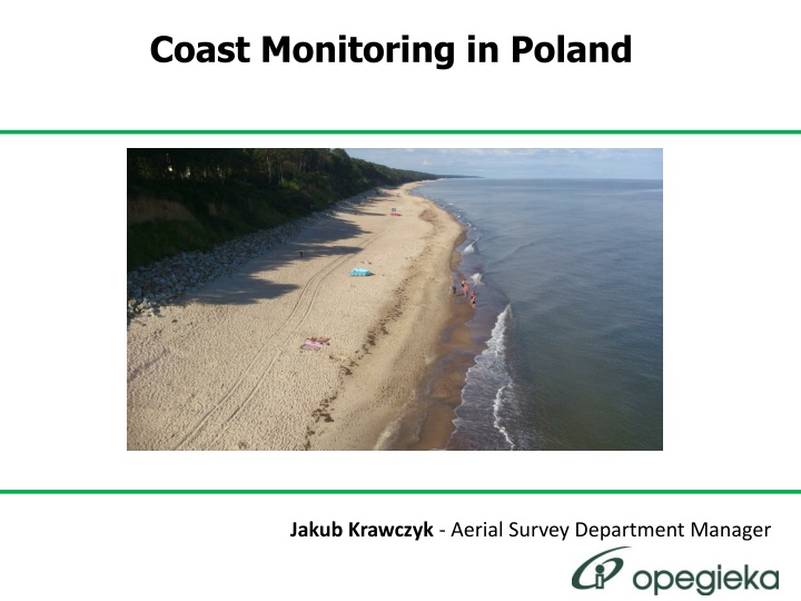
Coast Monitoring in Poland Jakub Krawczyk - Aerial Survey Department Manager
Presentation Agenda Remote sensing coast monitoring in Poland UAV in coast monitoring Research and development projects About OPEGIEKA
Remote sensing coast monitoring in Poland Data collected each year or in 2 years span This year will mark 5th edition of data collection Acquisition work since 2008 The data collected in regular time span can be used for advanced change monitoring
Remote sensing coast monitoring in Poland specification Width of data collection: 800m ALS and image data simultaneous acquisition DTM: 0,5m grid DSM: 0,5m grid Images: 10 cm GSD Orthophotomap: 15 cm GSD The data collected in regular time span can be used for advanced change monitoring
Remote sensing coast monitoring in Poland - Navigation and flight planning Data collected when the sea level is not higher than 10 cm above mean sea level At least one strip of data collected is required over the sea to capture dunes and cliffs
Remote sensing coast monitoring in Poland ALS data 8 pts/m2 20% overlap Full waveform data collection XY accuracy 0,2m Z accuracy 0,15m Full classification
Remote sensing coast monitoring in Poland ALS data Sample profile
Remote sensing coast monitoring in Poland ALS data Sample classification
Remote sensing coast monitoring in Poland Image data 10 cm GSD 20% overlap RGB spectral range Orthophotomap RMS 20cm
Remote sensing coast monitoring in Poland Image data Sample Orthophotmap
Remote sensing coast monitoring in Poland standardization 2008 control plane 1 2 3 4 5 6 7 8 9 10 11 12 2009 control plane 1 2 3 4 5 6 7 8 9 10 11 12 2011 control plane 1 2 3 4 5 6 7 8 9 10 11 12 2012 control plane 1 2 3 4 5 6 7 8 9 10 11 12 mean error 0.17 0.09 0.08 0.05 0.06 0.05 0.16 0.03 0.06 0.13 0.07 0.04 0.08 mean error 0.10 0.02 0.12 0.06 0.09 0.18 0.10 0.16 0.16 0.19 0.08 0.10 0.11 mean error 0,03 0,10 0,03 0,04 0,02 0,05 0,10 0,06 0,05 0,06 0,06 0,04 0,05 mean error 0.05 0.03 0.09 0.13 0.08 0.05 0.19 0.08 0.06 0.19 0.10 0.13 0.10 Accuracy of the elevation data
Remote sensing coast monitoring in Poland - equipment Twin Engine aircraft - Vulcanair P68 TC Observer Wingspan: 12 m Ceiling: 6100 m, range: 2280 km Speed: 315 km/h Maximum flight time : 8 h Medium-frame digital camera IGI DIGI CAM Resolution: 60 million pixels Laser scanner - RIEGL LMS-Q680i Frequency: 266 thousand points/sec Accuracy: 2 cm, Range: 3000 m Synchronized data collection for optimal monitoring
UAV in coast monitoring QuadroCopter MD4-1000 Wireless transmitter Control System AAHRS Altitude and Attitude and Heading Reference System Accelerometers, gyroscopes, air pressure humidityt and temperature sensors Diameter : 1,5m Range: 500m Flight time : 1h Alternative to traditional measurement.
UAV in coast monitoring test flight 11.04.2013 Short flight capturing images with 2.5 cm GSD
UAV in coast monitoring change detection Change detection between archive ALS data nda DTM derived from images from UAV flight
UAV in coast monitoring change detection Change detection between archive ALS data nda DTM derived from images from UAV flight
UAV in coast monitoring land mass Land mass difference 908 m3 Yellow additional sand 702m3, purple sand washed away 206m3
Status of Research & Development Center As stated in the decision of the Minister of Economy Janusz Piechoci ski of 13 August 2013 OPEGIEKA has joined a small group of commercial entities that have the national status of research and development center. Currently in Poland there are only 33 officially registered research and development centers of all sectors of the economy. link link
Experimental work on ROV for coast and infrastructure monitoring The project carried out jointly with the Gdansk University of Technology. Implementation period: 18 months The total value of the project: 1 984 248,00 PLN The value of the subsidy: 1 248 000,00 PLN OBJECTIVE: The aim of the project is to create a practical measurement technology using laser techniques. Project co-funded under the Applied Research Programme by the National Research and Development Center.
Underwater ROV Project co-funded under the Applied Research Programme by the National Research and Development Center.
Scanning system The aim of the project is to create a relatively cheap and safe monitoring system for port infrastructure
OPEGIEKA + GRE + CRDTI Geomonitor Project Experimental adaptation of aero-geophysical methods for the development of effective tools for monitoring the state of the levees and other linear civil infrastructure objects. The project carried out jointly with the Geophysical Research Enterprise and the Center for Research and Development of Technologies for Industry. Implementation period: 19 months The total value of the project: 9 424 651.68 PLN The funding: 6 013 031.26, 00 PLN OBJECTIVE: The aim of the project is to use practical unmanned vehicles to geophysical and geotechnical surveying. Project co-financed from the Operational Programme Innovative Economy 2007-2013, Priority I-IV, Measure 1.4 "Support for special projects."
OPEGIEKA + GRE + CRDTI Geomonitor Project SLIDES REMOVED (patent pending restrictions) New UAV design Patent Pending
OPEGIEKA OMNIGIS / TAGIS Projects OMNIGIS - Using SOA, SaaS, PaaS model for spatial data infrastructure Duration: 09.2010 06.2012 Total value of the project: 2.029.500 PLN UE funding: 1.130.750 PLN TAGIS - Research on the use of analytical systems in space-time decision support systems Duration: 04.2012 - 06.2014 Total value of the project: 1.955.800 PLN UE funding: 1.241.915 PLN Innovative Economy Operational Programme 2007-2013, Priority I-IV, Measure 1.4 - 4.1, "Support for special projects supporting the R&D results"
OPEGIEKA SMARTCLOUD Project Research on the construction of isolated private clouds. Implementation period: 12 months The total value of the project: own funds OBJECTIVE: The aim of the project is to provide technology and infrastructure for spatial information management, with the ability to dynamic allocation of resources, and billing for the actual use of equipment such as CPU, RAM, HDD. With SmartCloud technology user can create and make available on the web a server with installed operating system in less than 3 minutes.
OPEGIEKA 1946 Analogue Geodesy 1989 Privatization 1990 CAD Digital Maps 1995 GIS Object Maps 1998 Outsourcing of the Geodetic and Cartographic Documentation Center 2002 Digital photogrammetry 2005 GPS Technology 2009 - Company Transformation 2010 Aerial Platform 2011 DataCenter 2012 R&D Center In the last two years there has been significant development opportunities for the company. Thus the company has made large investments and started transforming itself into Research and Development Center.
jakub.krawczyk@Opegieka.pl +48 723 233 433 Thank you for your attention