DRONET: Learning to Fly by Driving


DRONET: LEARNING
TO FLY BY DRIVING
PAPER BY:
ANTONIO LOQUERCIO, ANA I. MAQUEDA, CARLOS R. DEL-BLANCO, AND DAVIDE
SCARAMUZZA
PRESENTED BY: LOGAN MURRAY


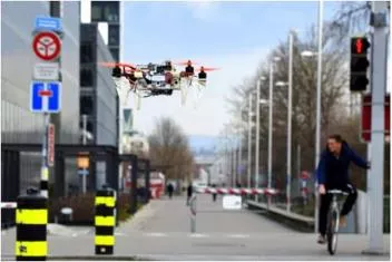
VIDEO OF DRONET IN ACTION

PROBLEM: SAFE AND RELIABLE OUTDOOR
NAVIGATION OF AUV’S
•
Ability to avoid obstacles while navigating.
•
Follow traffic or zone laws.
•
To solved these tasks, a robotic system must be able to solve perception, control, and
localization all at once.
•
In urban areas this becomes especially difficult
•
If this problem is solved, UAV’s could be used for many applications e.g. surveillance,
construction monitoring, delivery, and emergency response.

TRADITIONAL APPROACH
•
Two step process of automatic localization, and computation of controls.
•
Localize given a map using GPS, visual and range sensors.
•
Control commands allow the robot to avoid obstacles while achieving the desired goal.
•
Problems with this model:
•
Advanced SLAM algorithms have issues with dynamic scenes and appearance changes.
•
Separating the perception and control blocks introduces challenges with inferring control
commands from 3D maps.
RECENT APPROACH
•
Use deep learning to couple perception and control, which greatly increases results on a
large set of tasks
•
Problems:
•
Reinforcement Learning: suffers from high sample complexity
•
Supervised-Learning: Must have human expert flying trajectories to imitate
DRONET APPROACH
•
Residual Convolutional Neural Network(CNN)
•
Use a pre-recorded outdoor dataset recorded from cars and bikes
•
Collect a custom dataset of outdoor collision sequences
•
Real-time processing from one video camera on the UAV
•
Create steering angle controls and probability of collision
•
Have a generalized system that can adapt to unseen environments.
CNN PROCESS
TRAINING THE STEERING AND COLLISON
PREDICTIONS
•
Steering: Mean-Squared Error(MSE)
•
Collision Prediction: Binary Cross-Entropy(BCE)
•
Once trained, an optimizer is used to compute both steering and collision at the same
time.
DATASETS
•
Udacity dataset of 70,000 images of
car driving. 6 experiments, 5 for
training, 1 for testing.
•
IMU, GPS, gear, brake, throttle,
steering angles, and speed
•
One forward-looking camera
DATASETS (CONT.)
•
Collision dataset collected from a GoPro
mounted on the handlebars of a bike.
•
32,00 images distributed over 137
sequences for a set of obstacles.
•
Frames that are far away from obstacles are
labeled with 0(no collision), and frames that are
very close are labeled with a 1(collision).
•
Should not be collected by a drone, but
are necessary.
DRONE CONTROLS
•
Combination of forward velocity and steering angle
•
When collision = 0, forward velocity = Vmax
•
When collision = 1, forward velocity = 0
•
Perform low pass filter on the velocity Vk to provide smooth, continuous inputs.
Alpha= .7
•
Steering angle is calculated by mapping the predicted scaled steering Sk into a rotation
around the z-axis.
•
Then a low pass filter is applied. Beta = .5
RESULTS
•
Hardware Specs:
•
Drone-Parrot Bebop 2.0 drone
•
Core i7 2.6 GHz CPU that receives
images at 30 Hz from the drone
through Wi-Fi.
RESULTS (CONT.)
RESULTS
(CONT.)
RESULTS(CONT.)
RESULTS(CONT.)
RESULTS(CONT.)
•
Always produced a safe, smooth flight even when prompted with dangerous situations
•
e.g. sudden bikers or pedestrians in front of the robot.
•
Network focuses on “line-like” patterns to predict crowed or dangerous areas.
RESULTS(CONT.)
PROS VS LIMITATIONS
•
Pros
•
Drone can explore completely unseen environments with no previous knowledge
•
No required localization or mapping
•
CNN allows for high generalization capabilities
•
Can be applied to resource constrained platforms
•
Limitations
•
Does not fully exploit the agile movement capabilities of drones
•
No real way to give the robot a goal to be reached
REFERENECES
•
A.Loquercio, A.I. Maqueda, C.R. Del Blanco, D. Scaramuzza DroNet: Learning to Fly By
Driving IEEE Robotics and Automation Letters (RA-L), 2018
•
Deshpande, Adit. “A Beginner's Guide To Understanding Convolutional Neural
Networks.”
A Beginner's Guide To Understanding Convolutional Neural Networks – Adit
Deshpande – CS Undergrad at UCLA ('19), 20 July 2016, adeshpande3.github.io/A-
Beginner's-Guide-To-Understanding-Convolutional-Neural-Networks/.
DRONET presents a novel approach to safe and reliable outdoor navigation for Autonomous Underwater Vehicles (AUVs), addressing challenges such as obstacle avoidance and adherence to traffic laws. By utilizing a Residual Convolutional Neural Network (CNN) and a custom outdoor dataset, DRONET achieves real-time processing for steering controls and collision probability, demonstrating potential applications in surveillance, construction monitoring, delivery services, and emergency response scenarios.

Download Presentation

Please find below an Image/Link to download the presentation.
The content on the website is provided AS IS for your information and personal use only. It may not be sold, licensed, or shared on other websites without obtaining consent from the author.If you encounter any issues during the download, it is possible that the publisher has removed the file from their server.
You are allowed to download the files provided on this website for personal or commercial use, subject to the condition that they are used lawfully. All files are the property of their respective owners.
The content on the website is provided AS IS for your information and personal use only. It may not be sold, licensed, or shared on other websites without obtaining consent from the author.
E N D
Presentation Transcript
DRONET: LEARNING TO FLY BY DRIVING PAPER BY: ANTONIO LOQUERCIO, ANA I. MAQUEDA, CARLOS R. DEL-BLANCO, AND DAVIDE SCARAMUZZA PRESENTED BY: LOGAN MURRAY
PROBLEM: SAFE AND RELIABLE OUTDOOR NAVIGATION OF AUV S Ability to avoid obstacles while navigating. Follow traffic or zone laws. To solved these tasks, a robotic system must be able to solve perception, control, and localization all at once. In urban areas this becomes especially difficult If this problem is solved, UAV s could be used for many applications e.g. surveillance, construction monitoring, delivery, and emergency response.
TRADITIONAL APPROACH Two step process of automatic localization, and computation of controls. Localize given a map using GPS, visual and range sensors. Control commands allow the robot to avoid obstacles while achieving the desired goal. Problems with this model: Advanced SLAM algorithms have issues with dynamic scenes and appearance changes. Separating the perception and control blocks introduces challenges with inferring control commands from 3D maps.
RECENT APPROACH Use deep learning to couple perception and control, which greatly increases results on a large set of tasks Problems: Reinforcement Learning: suffers from high sample complexity Supervised-Learning: Must have human expert flying trajectories to imitate
DRONET APPROACH Residual Convolutional Neural Network(CNN) Use a pre-recorded outdoor dataset recorded from cars and bikes Collect a custom dataset of outdoor collision sequences Real-time processing from one video camera on the UAV Create steering angle controls and probability of collision Have a generalized system that can adapt to unseen environments.
TRAINING THE STEERING AND COLLISON PREDICTIONS Steering: Mean-Squared Error(MSE) Collision Prediction: Binary Cross-Entropy(BCE) Once trained, an optimizer is used to compute both steering and collision at the same time.
DATASETS Udacity dataset of 70,000 images of car driving. 6 experiments, 5 for training, 1 for testing. IMU, GPS, gear, brake, throttle, steering angles, and speed One forward-looking camera
DATASETS (CONT.) Collision dataset collected from a GoPro mounted on the handlebars of a bike. 32,00 images distributed over 137 sequences for a set of obstacles. Frames that are far away from obstacles are labeled with 0(no collision), and frames that are very close are labeled with a 1(collision). Should not be collected by a drone, but are necessary.
DRONE CONTROLS Combination of forward velocity and steering angle When collision = 0, forward velocity = Vmax When collision = 1, forward velocity = 0 Perform low pass filter on the velocity Vk to provide smooth, continuous inputs. Alpha= .7 Steering angle is calculated by mapping the predicted scaled steering Sk into a rotation around the z-axis. Then a low pass filter is applied. Beta = .5
RESULTS Hardware Specs: Drone-Parrot Bebop 2.0 drone Core i7 2.6 GHz CPU that receives images at 30 Hz from the drone through Wi-Fi.
RESULTS (CONT.)
RESULTS(CONT.) Always produced a safe, smooth flight even when prompted with dangerous situations e.g. sudden bikers or pedestrians in front of the robot. Network focuses on line-like patterns to predict crowed or dangerous areas.
PROS VS LIMITATIONS Pros Drone can explore completely unseen environments with no previous knowledge No required localization or mapping CNN allows for high generalization capabilities Can be applied to resource constrained platforms Limitations Does not fully exploit the agile movement capabilities of drones No real way to give the robot a goal to be reached
REFERENECES A.Loquercio, A.I. Maqueda, C.R. Del Blanco, D. Scaramuzza DroNet: Learning to Fly By Driving IEEE Robotics and Automation Letters (RA-L), 2018 Deshpande, Adit. A Beginner's Guide To Understanding Convolutional Neural Networks. A Beginner's Guide To Understanding Convolutional Neural Networks Adit Deshpande CS Undergrad at UCLA ('19), 20 July 2016, adeshpande3.github.io/A- Beginner's-Guide-To-Understanding-Convolutional-Neural-Networks/.


")


")

")
")
")
")