Cooper Spur Nordic Club Day Tour: Tilly Jane and Beyond in Oregon
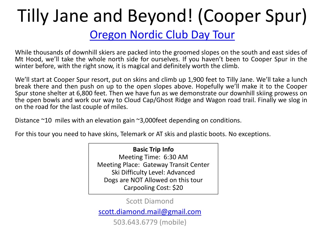

Tilly Jane and Beyond! (Cooper Spur)Oregon Nordic Club Day Tour
Scott Diamond
503.643.6779 (mobile)

Basic Trip Info
Meeting Time: 6:30 AM
Meeting Place: Gateway Transit Center
Ski Difficulty Level: Advanced
Dogs are NOT Allowed on this tour
Carpooling Cost: $20
While thousands of downhill skiers are packed into the groomed slopes on the south and east sides of
Mt Hood, we’ll take the whole north side for ourselves. If you haven’t been to Cooper Spur in the
winter before, with the right snow, it is magical and definitely worth the climb.
We’ll start at Cooper Spur resort, put on skins and climb up 1,900 feet to Tilly Jane. We’ll take a lunch
break there and then push on up to the open slopes above. Hopefully we’ll make it to the Cooper
Spur stone shelter at 6,800 feet. Then we have fun as we demonstrate our downhill skiing prowess on
the open bowls and work our way to Cloud Cap/Ghost Ridge and Wagon road trail. Finally we slog in
on the road for the last couple of miles.
Distance ~10 miles with an elevation gain ~3,000feet depending on conditions.
For this tour you need to have skins, Telemark or AT skis and plastic boots. No exceptions.

Cancellation
•
Cancellations are rare but they do occasionally
happen
•
Please check your e-mail before driving out to
carpool spot.
•
I’ll e-mail only if there is a cancel or change in
plans, otherwise the trip is on.
Tour Starting Point
•
We carpool from Gateway but we start skiing from
Tilly Jane Sno-Park
. This located just before final ¼
mile drive up to Cooper Spur Ski resort
Estimated Timing
•
6:30 AM Meet at Gateway
•
9:30 AM at Tilly Jane Sno Park(3,800 feet)
•
11:30 AM at Tilly Jane A-Frame (5,718 feet)
•
12:00 AM Continue up
•
1:30 PM at Stone Shelter (6,800 feet)
•
3:00 PM Cloud Cap (5,880 feet)
•
4:30 PM back at car (3,800 feet
•
6:30 PM back at Gateway
Note. There will be a wide
range of skiing abilities. We will
go down as a group and
descend with the slowest skier.
If you want to fly down then do
not do this tour
Technical Skiing Ability
Skiing Fitness
Isolation/Risk
Difficulty Rating Scale
Avalanche Hazard
•
Understandably, I get
asked about this. In
general this is a very safe
tour. There are a few
steep sections below tree
line but they are very
short.
•
Above tree line, in the
open bowls the slope is
less than 20 degrees and
there is little risk.
•
I bring a shovel but have
never brought transceiver
or probe poles.
Required Equipment
•
Everyone should have skins, plastic boots and good
turnings skis: Telemark or AT. No exceptions
NNN-BC Equipment is not suited
for this tour
Showing typical Telemark package
S
F
Detailed Route Info
•
We start at the Tilly Jane Sno Park at 3,800
feet and we climb up to 400 feet to 4,240
where we junction trail #643A - Polallie
Ridge
•
We take to Polallie Ridge trail all they way
up to the Tilly Jane A-frame
•
For the most part this section is pretty
straightforward. You need skins as it is
pretty steep but it is relatively
straightforward.
•
The Gnarl ridge forest fire in 2008 burned
though most of this area so it is not as
scenic as much of Hood but as you get up
higher we get our first glimpses of the
mountain.
•
The snow on this section is usually pretty
poor but don’t get too discouraged. Ghost
ridge and the Old Wagon road on our way
day generally has better snow.
•
After about an hour and a half of climbing
we come up the Tilly Jane A-frame for a
break. Usually there is a wood stove burning
and we can rest in relative warmth
Climbing up with skins
Finally a view of Hood
Tilly Jane A-Frame
Detailed Route Info
•
After leaving Tilly Jane the route gets a little more
interesting. We first wind our way along Polallie canyon
and have some great views as it drops off to our left.
•
We are in the trees at this point but pretty soon we
reach timberline and the trees thin out and they we
are presented with some of the most scenic bowls on
Mt. Hood.
•
Here we often enter the area of high winds. We’ll
either feel the high winds ourselves or the snow will be
pretty wind whipped.
•
We climb up until reaching the stone shelter
Skiing through trees above TJ
Surreal Bowls
Wind whipped snow
Stone Shelter on a tough day
Looking up at Hood
Detailed Route Info
•
We are finally ready to descend! Unfortunately, if you’ve come for
great skiing you may be disappointed. The view is stunning but
often the “snow” is miserable at this point. Think of sheets of ice.
•
We drop down into the gully just west of the stone shelter and
work our way along what in the summer is the Timberline trail
(trail 600). In some sense this is the crux of the tour. If we follow
the right trail we can get good skiing all the way to Cloud Cap and
not have to put skins on again
•
Usually as we get lower the snow improves
•
We finally make our way to the
Cloud Cap Inn
which is run by the
Crag Rats
•
At this point the most technically difficult skiing is over.
Working through gullies
Surreal Bowls
Descending through wind whipped snow. Yuck
Detailed Route Info
•
Once we reach Cloud cap we now enter the main section of
crossing and re-crossing the Cooper Spur road.
•
This section is Ghost Ridge or the old Wagon Road. It used to
be that you were on a narrow path through here (Wagon
Road) but with the Gnarl fire in 2008 this is pretty open and
you get to choose your route down (provided there is enough
snow to cover all the trees)
•
The terrain is not as steep and the snow is not wind whipped
so this is often pretty good skiing.
•
We do however have to cross through some thick sections of
trees. I haven’t worn a helmet in the past but it might be
appropriate.
•
Finally we cross the road at ~4,200 feet and cross country ski
back to the cars.
Tight Tree skiing
Good open skiing through the trees
Last stretch on the road
GPS Map Link
(you are not required to bring a GPS but I’m making this available)
•
GPS Track
on GPSies
–
The link above allows you to easily download a GPX file or you can use
their iPhone app
•
GPS Track
on CalTopo
–
The link above allows you to easily print a map of our route
Sample map from CalTopo
Background Info
ONC Carpooling Policy
If we don’t have drivers, we don’t have a trip.
If you
have a snow compatible car then please offer to
drive.
If we don’t have enough drivers then we’ll
do a lottery to see who goes.
For passengers, the ONC policy is each passenger
contributes 15 cents per mile. For three or more
passengers, the maximum total contribution by
all passengers is limited to 45 cents per mile. A
typical round trip distance to Mt Hood and back
is 120 miles to 160 miles = $18-$24/person
ONC Ski Rating
•
Novice level
–
These tours are for the inexperienced skiers. While this is not a lesson,
the leader will help new skiers as much as possible. Tour length is 3-5
miles over nearly flat terrain.
•
Beginning/Easy level
–
4 to 6 Miles over gentle terrain at a pace comfortable for all
participants
•
Intermediate level
–
6 to 12 miles. Terrain flat to long hills that are no steeper than found
on a road (maximum 10 degrees). Moderate pace. Trail turning skills
required, if there are hills.
•
Advanced level
–
> 12 miles. Terrain flat to steep hills (> 10 degrees). Moderate to fast
pace. Strong turning skills required on the tours with steeper slopes.
What to Bring/Gear
(click links below for more info)
•
Ski Rental Options
•
What to Wear
•
Tour Essentials
•
Chocolate for trip leaders.
Note that if you need to rent skis you’ll need to rent
them prior to the trip. It takes quite a while to rent and it
doesn’t work to split the group and try and regroup when
renting on the way
Maps/Guides
The best overall
reference books is
still Klindt Vielbig’s.
This is out of print
but you can still
find used copies on
Amazon
There are always new trails being developed
and the maps I have images for are not the
most recent. Therefore, please consider these
maps to be a rough guide at best.
If you want to buy your own maps for this trip
then the best one I’ve found for Mt. Hood is
the 2015 Mt. Hood Winter Trails
(
BuyBetterMaps
,
Amazon
or your local REI)
Electronic Map/GPS
•
I’ve given up carrying paper maps and
instead use my smartphone to see
the track and where I am
•
Numerous smartphone GPS apps are
available, my own favorite is
Gaia
($20).
See me at one of the club meetings if you need
some help using this.
Sample screen shot for
Gaia iPhone Software
Weather Reports
Obviously the tour gets cancelled if we don’t have enough
snow. Additionally if it looks like it is just going to rain on us all
day then we’ll cancel. I like to use the following site to check
the weather.
•
National Weather Service Zone Forecast.
Good general
description and snow level info.
•
Mount Hood WebCams
. Amar Andalkar does a great job at
pulling together all the WebCams. For day tours I like to look to
see how much snow there is in Government Camp
•
Northwest Avalanche Center
– Not applicable to the vast
majority of ONC tours (since we rarely ski on or across slopes
steep enough to avalanche)
Experience the serene beauty of the north side of Mt. Hood with the Cooper Spur Nordic Club Day Tour. Ski through enchanting landscapes, from Tilly Jane to Cloud Cap, showcasing your skiing skills along the way. Join fellow enthusiasts for a challenging yet rewarding adventure filled with stunning vistas and camaraderie. Remember to equip yourself with the necessary gear for this exceptional winter journey.

Download Presentation

Please find below an Image/Link to download the presentation.
The content on the website is provided AS IS for your information and personal use only. It may not be sold, licensed, or shared on other websites without obtaining consent from the author. Download presentation by click this link. If you encounter any issues during the download, it is possible that the publisher has removed the file from their server.
E N D
Presentation Transcript
Tilly Jane and Beyond! (Cooper Spur) Oregon Nordic Club Day Tour While thousands of downhill skiers are packed into the groomed slopes on the south and east sides of Mt Hood, we ll take the whole north side for ourselves. If you haven t been to Cooper Spur in the winter before, with the right snow, it is magical and definitely worth the climb. We ll start at Cooper Spur resort, put on skins and climb up 1,900 feet to Tilly Jane. We ll take a lunch break there and then push on up to the open slopes above. Hopefully we ll make it to the Cooper Spur stone shelter at 6,800 feet. Then we have fun as we demonstrate our downhill skiing prowess on the open bowls and work our way to Cloud Cap/Ghost Ridge and Wagon road trail. Finally we slog in on the road for the last couple of miles. Distance ~10 miles with an elevation gain ~3,000feet depending on conditions. For this tour you need to have skins, Telemark or AT skis and plastic boots. No exceptions. Basic Trip Info Meeting Time: 6:30 AM Meeting Place: Gateway Transit Center Ski Difficulty Level: Advanced Dogs are NOT Allowed on this tour Carpooling Cost: $20 Scott Diamond scott.diamond.mail@gmail.com 503.643.6779 (mobile)
Cancellation Cancellations are rare but they do occasionally happen Please check your e-mail before driving out to carpool spot. I ll e-mail only if there is a cancel or change in plans, otherwise the trip is on.
Tour Starting Point We carpool from Gateway but we start skiing from Tilly Jane Sno-Park. This located just before final mile drive up to Cooper Spur Ski resort
Estimated Timing 6:30 AM Meet at Gateway 9:30 AM at Tilly Jane Sno Park(3,800 feet) 11:30 AM at Tilly Jane A-Frame (5,718 feet) 12:00 AM Continue up 1:30 PM at Stone Shelter (6,800 feet) 3:00 PM Cloud Cap (5,880 feet) 4:30 PM back at car (3,800 feet 6:30 PM back at Gateway Note. There will be a wide range of skiing abilities. We will go down as a group and descend with the slowest skier. If you want to fly down then do not do this tour
Difficulty Rating Scale 5 5 5 4 4 4 3 3 3 2 2 2 1 1 1 0 0 0 Technical Skiing Ability Skiing Fitness Isolation/Risk
Avalanche Hazard Understandably, I get asked about this. In general this is a very safe tour. There are a few steep sections below tree line but they are very short. Above tree line, in the open bowls the slope is less than 20 degrees and there is little risk. I bring a shovel but have never brought transceiver or probe poles.
Required Equipment Everyone should have skins, plastic boots and good turnings skis: Telemark or AT. No exceptions NNN-BC Equipment is not suited for this tour Showing typical Telemark package
F S
Detailed Route Info We start at the Tilly Jane Sno Park at 3,800 feet and we climb up to 400 feet to 4,240 where we junction trail #643A - Polallie Ridge We take to Polallie Ridge trail all they way up to the Tilly Jane A-frame For the most part this section is pretty straightforward. You need skins as it is pretty steep but it is relatively straightforward. The Gnarl ridge forest fire in 2008 burned though most of this area so it is not as scenic as much of Hood but as you get up higher we get our first glimpses of the mountain. The snow on this section is usually pretty poor but don t get too discouraged. Ghost ridge and the Old Wagon road on our way day generally has better snow. After about an hour and a half of climbing we come up the Tilly Jane A-frame for a break. Usually there is a wood stove burning and we can rest in relative warmth Climbing up with skins Finally a view of Hood Tilly Jane A-Frame
Detailed Route Info After leaving Tilly Jane the route gets a little more interesting. We first wind our way along Polallie canyon and have some great views as it drops off to our left. We are in the trees at this point but pretty soon we reach timberline and the trees thin out and they we are presented with some of the most scenic bowls on Mt. Hood. Here we often enter the area of high winds. We ll either feel the high winds ourselves or the snow will be pretty wind whipped. We climb up until reaching the stone shelter Skiing through trees above TJ Surreal Bowls Looking up at Hood Stone Shelter on a tough day Wind whipped snow
Detailed Route Info We are finally ready to descend! Unfortunately, if you ve come for great skiing you may be disappointed. The view is stunning but often the snow is miserable at this point. Think of sheets of ice. We drop down into the gully just west of the stone shelter and work our way along what in the summer is the Timberline trail (trail 600). In some sense this is the crux of the tour. If we follow the right trail we can get good skiing all the way to Cloud Cap and not have to put skins on again Usually as we get lower the snow improves We finally make our way to the Cloud Cap Inn which is run by the Crag Rats At this point the most technically difficult skiing is over. Working through gullies Surreal Bowls Descending through wind whipped snow. Yuck
Detailed Route Info Once we reach Cloud cap we now enter the main section of crossing and re-crossing the Cooper Spur road. This section is Ghost Ridge or the old Wagon Road. It used to be that you were on a narrow path through here (Wagon Road) but with the Gnarl fire in 2008 this is pretty open and you get to choose your route down (provided there is enough snow to cover all the trees) The terrain is not as steep and the snow is not wind whipped so this is often pretty good skiing. We do however have to cross through some thick sections of trees. I haven t worn a helmet in the past but it might be appropriate. Finally we cross the road at ~4,200 feet and cross country ski back to the cars. Tight Tree skiing Last stretch on the road Good open skiing through the trees
GPS Map Link (you are not required to bring a GPS but I m making this available) GPS Track on GPSies The link above allows you to easily download a GPX file or you can use their iPhone app GPS Track on CalTopo The link above allows you to easily print a map of our route Sample map from CalTopo
ONC Carpooling Policy If we don t have drivers, we don t have a trip. If you have a snow compatible car then please offer to drive. If we don t have enough drivers then we ll do a lottery to see who goes. For passengers, the ONC policy is each passenger contributes 15 cents per mile. For three or more passengers, the maximum total contribution by all passengers is limited to 45 cents per mile. A typical round trip distance to Mt Hood and back is 120 miles to 160 miles = $18-$24/person
ONC Ski Rating Novice level These tours are for the inexperienced skiers. While this is not a lesson, the leader will help new skiers as much as possible. Tour length is 3-5 miles over nearly flat terrain. Beginning/Easy level 4 to 6 Miles over gentle terrain at a pace comfortable for all participants Intermediate level 6 to 12 miles. Terrain flat to long hills that are no steeper than found on a road (maximum 10 degrees). Moderate pace. Trail turning skills required, if there are hills. Advanced level > 12 miles. Terrain flat to steep hills (> 10 degrees). Moderate to fast pace. Strong turning skills required on the tours with steeper slopes.
What to Bring/Gear (click links below for more info) Ski Rental Options What to Wear Tour Essentials Chocolate for trip leaders. Note that if you need to rent skis you ll need to rent them prior to the trip. It takes quite a while to rent and it doesn t work to split the group and try and regroup when renting on the way
Maps/Guides There are always new trails being developed and the maps I have images for are not the most recent. Therefore, please consider these maps to be a rough guide at best. If you want to buy your own maps for this trip then the best one I ve found for Mt. Hood is the 2015 Mt. Hood Winter Trails (BuyBetterMaps, Amazon or your local REI) The best overall reference books is still Klindt Vielbig s. This is out of print but you can still find used copies on Amazon
Electronic Map/GPS I ve given up carrying paper maps and instead use my smartphone to see the track and where I am Numerous smartphone GPS apps are available, my own favorite is Gaia ($20). See me at one of the club meetings if you need some help using this. Sample screen shot for Gaia iPhone Software
Weather Reports Obviously the tour gets cancelled if we don t have enough snow. Additionally if it looks like it is just going to rain on us all day then we ll cancel. I like to use the following site to check the weather. National Weather Service Zone Forecast. Good general description and snow level info. Mount Hood WebCams. Amar Andalkar does a great job at pulling together all the WebCams. For day tours I like to look to see how much snow there is in Government Camp Northwest Avalanche Center Not applicable to the vast majority of ONC tours (since we rarely ski on or across slopes steep enough to avalanche)
")