Data Types and Summary Statistics in Exploratory Data Analysis
Data types, including discrete numerical, continuous numerical, ordinal, and nominal, are essential in exploratory data analysis. Variables can be categorized based on their nature, such as numerical variables (interval vs. ratio) and categorical data summaries. Learn about USGS flow measurements, n
4 views • 48 slides
Fulfilling FSP Responsibilities at US Geological Survey
Supervisors at the US Geological Survey play a crucial role in overseeing project proposal and plan development, ensuring compliance with Fundamental Science Practices (FSP). This involves managing USGS authors, deciding on research result categorization, releasing data, and adhering to open science
0 views • 19 slides
Seasonal Flood Monitoring and Forecast in East Africa and Yemen (March 2023)
Enhanced flood monitoring and forecast assumptions for East Africa and Yemen for the season of March 2023, including specific details on flooding conditions in South Sudan, streamflow forecasts for the Blue Nile, Victoria Nile, Rwanda, Burundi, and Yemen. The analysis also predicts seasonal flooding
1 views • 6 slides
Status Update: PDS Node Activities and Concerns Summary
This report presents updates on PDS Node activities discussed at the PDS Management Council Meeting. Topics include archiving schedules for Europa Clipper Mission, funding status, time spent on PDS-wide activities, PDART and DMPs progress, and staffing concerns at USGS-IMG. Notable activities such a
1 views • 6 slides
Formation of Finger Lakes Geology
Explore the geology and formation of the Finger Lakes region as detailed in the USGS Professional Paper 1089 by Fullerton (1980). Learn about the intriguing processes that shaped these unique lakes and their surrounding landscapes. Stunning images depict the geological features and illustrate how th
0 views • 6 slides
Initiating a Lunar Planetary Spatial Data Infrastructure (PSDI) by MAPSIT Steering Committee
MAPSIT, led by Trent Hare of USGS, advocates for creating a Lunar PSDI to enhance spatial data infrastructure in planetary science. The committee highlights the importance of foundational lunar data products and ongoing efforts for Europa and the Moon. Collaboration with various entities is emphasiz
0 views • 10 slides
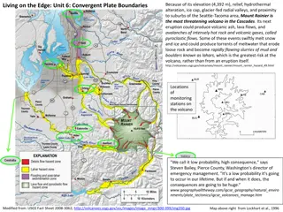
Mount Rainier Volcano Threats and Monitoring Data
Mount Rainier, with its elevation, proximity to residential areas, and geological features, poses significant volcanic hazards such as pyroclastic flows, lahars, and more. Monitoring data from USGS alert levels, seismic activity, and tilt measurements provide insights into potential volcanic activit
0 views • 9 slides
SilvaCarbon Collaboration with GOFC GOLD for Forest Carbon Measurement
SilvaCarbon is a flagship program supported by U.S. funding for REDD+ initiatives, focusing on improved forest inventories and remote sensing. Partners include USGS, NASA, and other institutions, working with various countries to enhance forest monitoring systems and capacity building efforts. Colla
0 views • 10 slides
Chehalis River Basin Flood Preparedness Update - Fall 2021
Comprehensive update on preparations for flood season in the Chehalis River Basin, including routine monitoring activities, permit renewals, gauge relocations, webcam updates, and rainfall outlook. Key highlights include securing permits, gauge relocations, webcam status, and USGS report on the oper
0 views • 16 slides
Innovative Seismic Software and Services for Geophysics Applications
Celebrating 20 years of providing seismic software, dataloggers, and sensors, this company was founded by the original IRIS PASSCAL programming team. With expertise in micro-seismic monitoring and a focus on wide-band, low-power, and portable solutions, they offer sensors with various specifications
0 views • 5 slides
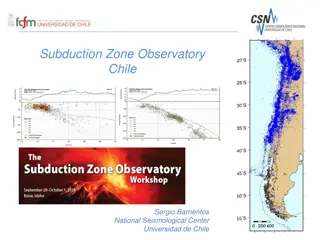
Monitoring Chile's Geological and Volcanic Activity: Subduction Zone Observatory and IPOC Network
Chile's Subduction Zone Observatory, led by Sergio Barrientos at the National Seismological Center, University of Chile, focuses on observing seismic and geological events with cutting-edge technology and networks. The IPOC Chile Volcanological Network monitors around 40 volcanoes, utilizing various
0 views • 4 slides
Watershed Delineation Comparison: USGS vs ESRI Ready-to-Use Method
Explore the comparison between USGS and ESRI Ready-to-Use methods for watershed delineations. Detailed analysis showcases the advantages and drawbacks of each approach, highlighting factors like accuracy, reliability, and efficiency. Get insights into workflow processes, time requirements, and overa
1 views • 27 slides
Progress Update on Portfolio Management Action Plan for National Geospatial Advisory Committee Meeting
The update entails the implementation status of the A-16 Portfolio Management Action Plan discussed at the National Geospatial Advisory Committee Meeting on June 6, 2013. Key points include GAO recommendations, team approach strategies, action plans, and the status of implementing these actions. Not
0 views • 8 slides
Estimation Methodology for Phosphorus and Sediment Loading in Cayuga Lake Watershed
Explore the process of estimating phosphorus and sediment loading at the south end of Cayuga Lake using LOADEST methodology. Learn how to combine synoptic monitoring data with USGS flow measurements and run calculations to obtain yearly load numbers. Get step-by-step instructions and access helpful
0 views • 13 slides
National Digital Orthoimagery Program (NDOP) Update - Coordination Group Meeting Summary
The NDOP Subcommittee focuses on developing and executing a national strategy for acquiring orthoimagery data for Federal agencies. Recent meetings and FY13 imagery datasets were discussed, along with updates on projects such as the Urban Areas Program. The USGS National Geospatial Program changes f
0 views • 31 slides
