
WISK: A Workload-aware Learned Index for Spatial Keyword Queries
WISK, a workload-aware learned index that combines spatial and keyword queries to efficiently retrieve objects. It integrates spatial and textual indexes and considers query workload information.
1 views • 17 slides

fMRI Coregistration and Spatial Normalization Methods
fMRI data analysis involves coregistration and spatial normalization to align functional and structural images, reduce variability, and prepare data for statistical analysis. Coregistration aligns images from different modalities within subjects, while spatial normalization achieves precise anatomic
3 views • 35 slides

Coregistration and Spatial Normalization in fMRI Analysis
Coregistration and Spatial Normalization are essential steps in fMRI data preprocessing to ensure accurate alignment of functional and structural images for further analysis. Coregistration involves aligning images from different modalities within the same individual, while spatial normalization aim
6 views • 42 slides

Localised Adaptive Spatial-Temporal Graph Neural Network
This paper introduces the Localised Adaptive Spatial-Temporal Graph Neural Network model, focusing on the importance of spatial-temporal data modeling in graph structures. The challenges of balancing spatial and temporal dependencies for accurate inference are addressed, along with the use of distri
4 views • 19 slides

Introduction to Spatial Data Mining: Discovering Patterns in Large Datasets
Spatial data mining involves uncovering valuable patterns from extensive spatial datasets, offering insights into historical events, environmental phenomena, and predictive analytics. Examples range from analyzing disease outbreaks to predicting habitat suitability for endangered species. The applic
2 views • 20 slides

Advanced Techniques in 3D Scene Analysis for Spatial Understanding
Cutting-edge research in 3D scene analysis focuses on sequenced predictions over points and regions for comprehensive spatial understanding. The approach involves contextual classification, overcoming limitations of classical graphical models through innovative inference machines that prioritize tra
0 views • 40 slides

Spatial Database Systems: An Overview
This presentation by Xiaozhi Yu introduces the fundamentals of spatial database systems, covering topics such as spatial data types, relationships, system architecture, modeling, and organizing underlying spaces. It delves into the importance of integrating geometry into DBMS data models, spatial in
2 views • 30 slides
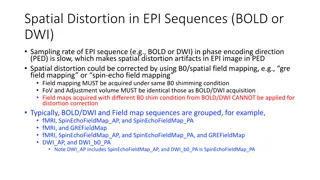
Spatial Distortion Correction in EPI Sequences: Field Mapping Examples
Spatial distortion artifacts in EPI sequences (BOLD or DWI) due to slow sampling rates in the phase encoding direction can be corrected using B0/spatial field mapping techniques. This correction requires obtaining field maps under the same B0 shimming conditions and with identical FoV and adjustment
2 views • 4 slides
Unlocking Creativity and Innovation: Lateral Thinking vs Logical Thinking
Embrace the power of lateral thinking to challenge assumptions, generate new possibilities, and break free from traditional logic. Discover how logical thinking and lateral thinking differ in their approach to problem-solving, and learn how to leverage both methods to spur creativity and innovation.
1 views • 35 slides
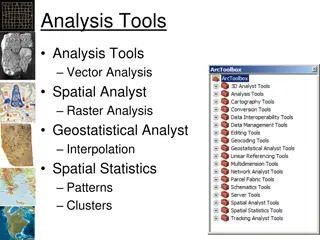
Spatial Analysis in GIS for Effective Decision-Making
Spatial analysis in GIS involves modeling geographic problems, processing data, and exploring results to understand spatial relationships, patterns, and suitability for various purposes. GIS tools offer unique capabilities for handling geographically referenced data, data entry, storage, manipulatio
3 views • 21 slides

Spatial Referencing Systems for Mapping
Spatial reference systems play a crucial role in defining geographic parameters and coordinate systems for mapping. They consist of components like orientation, latitude, longitude, and elevation, which help in representing spatial properties on maps. Reference surfaces such as the Geoid and ellipso
5 views • 13 slides
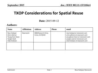
IEEE 802.11-20/0410r4 Coordinated Spatial Reuse Procedure
This document presents the Coordinated Spatial Reuse (CSR) procedure in IEEE 802.11-20/0410r4, focusing on the transmission schemes and necessary information for effective spatial reuse. It outlines the topology of CSR environments, acquisition of information for CSR, CSR capability announcement by
10 views • 23 slides

Spatial Analysis & Modeling for Spatial Planning Training in Maputo, Mozambique
Explore spatial analysis techniques for efficient route planning, site selection, pattern identification, and value prediction in the context of spatial planning. Learn about surface modeling, relationships among features, and the importance of spatial modeling in addressing geographical problems.
0 views • 27 slides
The Components of GIS for Spatial Planning
A geographic information system (GIS) is a powerful tool for capturing, storing, analyzing, and presenting spatial data. This training program explores the fundamentals of GIS, including software and hardware components, data considerations, and the importance of people and policies in utilizing GIS
6 views • 16 slides

GIS Data Models for Spatial Planning Training in Maputo, Mozambique
Explore the concepts of GIS data models including vector vs. raster, spatial relationships, spatial operations, and representation of real-world entities in a spatial database. Understand how spatial data models are used to manipulate spatially-referenced information and define the spatial location
1 views • 32 slides
Spatial Autocorrelation in Geostatistical Analysis
Explore the concept of spatial autocorrelation, its implications in geostatistical analysis, and the importance of detecting and interpreting it correctly. Learn about auto-correlation, signal components, correlation significance, and measuring autocorrelation using tools like Moran's I. Gain insigh
1 views • 12 slides

Future Directions for GIS in Samoa
Enhancing GIS practices in Samoa involves establishing a Samoa GIS User Group, improving spatial data management, developing a national spatial data infrastructure framework, and implementing GIS applications in various sectors like emergency response, public access, and natural resource management.
3 views • 12 slides

Spatial Relation Switching Requirements in 3GPP NR RAN Plenary Meeting
The document discusses various spatial relation switching requirements for uplink scenarios in the 3GPP NR RAN Plenary Meeting. It covers agreement points related to UL SRS, PUCCH, P-SRS, and DL-RS, defining delay requirements and known conditions for spatial relation switching. The agreements provi
0 views • 11 slides

Spatial Stream Allocation in IEEE 802.11-20 Trigger Frames
The document discusses spatial stream allocation in IEEE 802.11-20 trigger frames, specifically focusing on the SS Allocation subfield. It explains how trigger frames allocate resources for TB PPDU transmissions and solicit User Info fields, detailing the RU Allocation and SS Allocation subfields. T
4 views • 15 slides
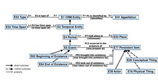
Temporal and Spatial Information Models
This content delves into the intricacies of temporal and spatial information models, covering concepts such as existence, presence, and spatiotemporal relationships. It explores how entities are identified, events are witnessed, and durations are defined within these models. The interplay between ti
4 views • 9 slides

Spatial Extremes: Complex Time Methods in Hydro-Atmospheric Dynamics
This study explores the use of complex time methods and chameleon scalar fields in understanding and modeling spatial extremes in hydrological and atmospheric systems. By transforming Lagrangian processes and introducing chameleon scalar fields, the research unveils new insights into the mechanism g
0 views • 9 slides

Coordinated Spatial Nulling (C-SN) Simulations in IEEE 802.11-24/0012r0
The document discusses the concept of Coordinated Spatial Nulling (C-SN) in IEEE 802.11-24/0012r0, focusing on spatial nulling feedback, synchronization needs, advantages of partial nulling, and comparison of half-coordinated versus fully coordinated scenarios. Simulation results are presented, anal
0 views • 19 slides

Spatial Racism and Its Role in the Flint Water Crisis
Professor Peter J. Hammer's testimony before the Michigan Civil Rights Commission sheds light on the historical lineage of spatial racism in Flint and Genesee County. The interaction between beliefs and institutions over time has shaped racial oppression, from slavery to current issues such as the F
0 views • 38 slides

Enhancing Spatial Data Analysis in QGIS
Explore the integration of relational databases with QGIS to facilitate efficient spatial data analysis. Discover the importance of recognizing spatial relationships within data sets and the solutions to enhance QGIS for relational datasets. Overcome challenges and delve into the intersection and su
0 views • 25 slides
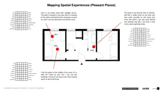
Spatial Experiences in a Small Flat
Mapping spatial experiences in a small flat, this content describes pleasant and unpleasant places within the living space. It highlights favorite spots like a kitchen chair with a view, a cozy desk for work, and a room with enough space for activities. In contrast, it mentions bothersome areas like
0 views • 10 slides

Marine Spatial Data Infrastructures Report Overview
The report provides insights into the activities and discussions at the EAHC-MSDIWG1 meeting held in Busan, ROK. It outlines the key agenda items, country reports on national MSDI, membership details, importance of MSDI, and trends in marine spatial data. The report emphasizes the significance of ma
0 views • 11 slides
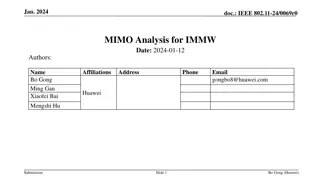
Analysis of MIMO for IMMW Transmission in IEEE 802.11-24
Proposal discusses the suitability of MIMO for IMMW transmission under different scenarios. The analysis focuses on the number of spatial streams based on channel rank and quality, recommending dual-polarization for LOS paths supporting 2 spatial streams and spatial separation for larger devices sup
0 views • 16 slides

XMM EPIC-pn Spatial CTI Correction using Cu K? and Mn K?
Detailed procedures for spatial CTI correction using Cu K? and Mn K? in XMM EPIC-pn detectors, including applying long-term CTI corrections, stacking event lists, extracting spectra, fitting Cu K line, and deriving spatial offsets. Examples show improvements in velocity space after corrections. Vali
0 views • 18 slides

Spatial Multi-Attribute Decision Analysis with Incomplete Preference Information
In this study by Mikko Harju, Juuso Liesi, and Kai Virtanen from Aalto University, the focus is on spatial decision analysis for scenarios where decision alternatives have varying consequences across a geographical region. The research delves into the significance of spatial value functions in repre
0 views • 19 slides

Practical English Lessons on Giving Directions and Spatial Relations
Engage in interactive English learning with topics covering asking for directions, city landmarks, spatial relations, and more. Understand key phrases for seeking directions and explore a city map to navigate locations using descriptive spatial terms. Enhance your language skills with practical exer
0 views • 17 slides

ICAR KRISHI Geo-Portal: Spatial Agricultural Research Information
ICAR KRISHI Geo-Portal is a digital platform aiming to facilitate spatial agricultural data generation, compilation, visualization, and analysis. It hosts spatial databases, provides map services, and allows data sharing across platforms. The portal, developed using open-source technologies, offers
1 views • 32 slides

Enhancing Critical Thinking in EAP Writing: A Meta-Synthesis Study
Investigating the teaching approaches to critical thinking in EAP writing classes, this meta-synthesis research delves into the importance of critical thinking, key issues in the literature review, defining critical thinking, enhancing criticality in academic writing, and understanding critical thin
0 views • 14 slides

Enhancing Critical and Creative Thinking in Education
The Victorian Curriculum F-10 emphasizes the development of critical and creative thinking skills among students. By focusing on understanding thinking processes, fostering confidence in evaluating thinking across various contexts, and promoting logical and strategic thinking, this curriculum aims t
0 views • 5 slides

Creativity and Design Thinking Strategies
Understand the concepts of divergent and convergent thinking in creativity, the importance of empathetic thinking in design, and the role of lateral thinking in generating innovative ideas. Guidelines emphasize the need to allow sufficient time for divergent thinking to foster creative outcomes befo
0 views • 16 slides

Spatial Relationships in Data Modeling
Explore the concept of spatial relationships within data modeling, focusing on the fully-articulated paths encompassing E4 Period, E53 Place, and E18 Physical Thing. Delve into the implications of properties like P161 has spatial projection and P89 falls within, examining how places are uniquely def
0 views • 7 slides

Spatial Resolution in Astronomical Imaging
This lecture delves into the requirements for resolution and sensitivity in astronomical imaging, exploring factors such as spatial resolution, optical design aberrations, and noise sources. It explains how spatial resolution is crucial in distinguishing objects, discussing the Rayleigh criterion an
0 views • 45 slides

Fourier Theory in Seismic Processing
Fourier theory plays a crucial role in seismic processing by helping to avoid temporal and spatial aliasing. It emphasizes the importance of sampling rates for accurate waveform reconstruction and highlights the significance of oversampling to prevent aliasing issues. Spatial aliasing is discussed i
0 views • 18 slides
Spatial Continuity in Geostatistics
Explore the concept of spatial continuity in geostatistics through descriptive analysis of sample data, variograms, covariance functions, and omnidirectional variograms. Learn about terminologies such as range, sill, and nugget effect, and the importance of omnidirectional variograms in capturing ov
0 views • 40 slides

Spatial Analysis of Apartment Layout by Carlos Pozo
Carlos Pozo conducted a spatial analysis of an apartment layout, focusing on centrality, distances from the entrance, and spatial relations between different activities. The findings highlight how the design influences human behavior and privacy within the living space.
0 views • 4 slides
IEEE 802.11-15/1104r4: Optimizing CCA Threshold for Spatial Reuse in WLANs
The document discusses considerations for optimizing the Clear Channel Assessment (CCA) threshold in wireless local area networks (WLANs) to enhance spatial reuse efficiency. It emphasizes minimizing over-protection caused by the current CCA rule while addressing factors like frequency reuse, BSS/OB
0 views • 18 slides