Understanding Latitude, Longitude, and Earth's Shape
Explore the concepts of latitude, longitude, and the shape of the Earth through informative content. Discover the significance of the troposphere, continental crust density, and proofs that the Earth is round. Learn how latitude is measured, the role of Polaris (North Star), and how these elements i
2 views • 15 slides

Understanding Spatial Referencing Systems for Mapping
Spatial reference systems play a crucial role in defining geographic parameters and coordinate systems for mapping. They consist of components like orientation, latitude, longitude, and elevation, which help in representing spatial properties on maps. Reference surfaces such as the Geoid and ellipso
3 views • 13 slides
Guidelines and Solutions for Geo-Tagging Concerns in Rural Development
Explore essential information and solutions related to geo-tagging in rural development projects. Learn about manpower allocation, latitude/longitude issues, offline processes, beneficiary identification challenges, and incentive payments for geo-taggers.
0 views • 7 slides
Understanding Geolocation: What You Need to Know
Geolocation is a built-in browser functionality that allows web applications to be location-aware. It uses geographic latitude/longitude and is supported by all modern browsers, making it an integral part of the HTML5/W3C JavaScript API. With geolocation, you can show users their position on a map,
0 views • 16 slides
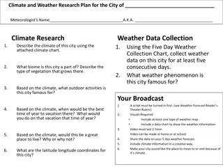
Climate and Weather Research Plan for the City
Meteorologist's research plan for a city including climate description, weather data collection, outdoor activities, best time to visit, living suitability, and latitude/longitude coordinates. The plan involves creating a script, visuals, video, and a weather forecast broadcast to showcase the city'
0 views • 5 slides
Understanding Basic Map Skills and Terms
Explore the essential map skills and terms such as map key/legend, compass rose, scale, latitude, longitude, Equator, Prime Meridian, hemispheres, and more to enhance your map reading and interpretation skills effectively.
0 views • 7 slides
Understanding Longitude and its Significance in Navigation
Longitude plays a crucial role in determining location on the Earth's surface, helping sailors and navigators pinpoint their positions accurately. It involves the angular distance east or west of the Prime Meridian located in Greenwich, England. By using precise timekeeping and astronomical observat
0 views • 16 slides
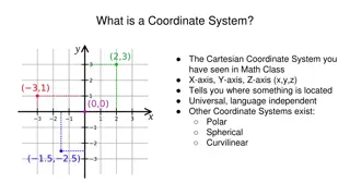
Understanding Coordinate Systems in Mathematics and Astronomy
Coordinate systems such as Cartesian, Polar, and Celestial serve as frameworks for locating points in space. They include dimensions like x, y, z axes in Cartesian, Latitude and Longitude on Earth, and various systems for astronomical observations. Different coordinate systems cater to specific purp
0 views • 11 slides
Understanding Map Concepts: An Overview
Exploring essential map-related terms and concepts such as map projection, hemisphere, latitude, longitude, scale, equator, prime meridian, map symbol, and globe. Enhance your understanding of how maps represent Earth's surface and the key elements involved in cartography.
0 views • 14 slides
Measurement Technique for Meridional Circulation in Solar Activity
In this research, time-distance measurements were conducted to study meridional circulation in solar activity. The east-west signal was found to be similar to the north-south signal, prompting analysis steps involving spherical harmonics computation, image reconstruction, filtering, cross-correlatio
0 views • 7 slides
Understanding the Significance of Latitude and Longitude Grid on Earth's Surface
Latitude and longitude form a grid of imaginary lines that are essential for pinpointing locations on Earth. The equator divides the planet into North and South hemispheres, while the prime meridian separates it into East and West hemispheres. With coordinates expressed using degrees, understanding
0 views • 9 slides
Understanding Earth's Geography: Location, Coordinates, and Hemispheres
Explore the concepts of absolute and relative locations, lines of latitude and longitude, GPS coordinates, and hemispheres in geography. Learn how to create a compass rose and label continents and oceans on a map. Understand how to describe locations using landmarks, direction, time, and distance.
0 views • 10 slides
Understanding Geography: The Study of Earth's Features and Human Interaction
Geography is the study of the Earth's physical and human features, their interaction, and how location impacts people's lives. It involves defining terms like longitude, latitude, equator, and prime meridian to understand relative and absolute locations. Geography helps us appreciate the nature of p
0 views • 14 slides
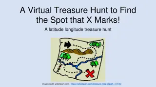
Discover the Exciting World of Latitude and Longitude
Dive into a virtual treasure hunt where you'll explore the concepts of latitude and longitude. Learn about the lines of latitude and longitude, hemispheres, coordinate choices, and how they help us pinpoint specific locations on a map. Test your skills with engaging activities and practice identifyi
0 views • 17 slides
Understanding Climatology for Building Design: Essentials and Applications
Explore the fundamentals of climatology for designing sustainable and comfortable built environments. Learn about the influence of climate on architecture, elements of climate, thermal comfort, natural ventilation, site climate, day lighting, shading devices, and more. Delve into the study of weathe
0 views • 9 slides

The Role of Time in Determining Longitude: A Historical Perspective
Exploring the pivotal role of time in the determination of longitude, this article delves into the historical background of John Harrison's invention of accurate timekeeping devices to solve the longitude problem, leading to a transformation in maritime navigation. By understanding the relationship
0 views • 16 slides
Understanding Geodetic Datums and WGS-84 Coordinates
Geodetic datums define the earth's shape and size, serving as reference points on coordinate systems. Vertical datums establish zero surface elevation, while horizontal datums form the basis for horizontal coordinates. The World Geodetic System 1984 (WGS-84) is the reference system used by GPS and l
0 views • 29 slides

Geographic Concepts Explained with Visuals
Explore various geographic concepts such as time zones, latitude, albedo, environmental spheres, and interactions between spheres through informative images and descriptions. Topics include longitude measurements, Tropic of Cancer location, hemispheres identification, time zone differences, environm
0 views • 34 slides
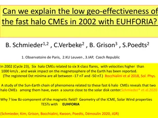
Understanding Low Geo-Effectiveness of Fast Halo CMEs in 2002 with EUHFORIA
Study investigates the puzzling low impact of fast halo CMEs associated with X-class flares in 2002 on Earth's magnetosphere. Despite high velocities, the weak geomagnetic effects were linked to a low Bz-component of the magnetic field, lack of relationship with longitude, and other factors. Utilizi
0 views • 17 slides
Understanding Geographic Coordinates: Importance and Significance
Explore the significance of geographic coordinates in oceanography and ecosystems. Learn why wind plays a crucial role in various oceanographic disciplines. Discover how latitude and longitude are utilized to pinpoint locations on Earth's surface, whether using degrees, minutes, seconds or decimal d
0 views • 31 slides
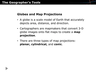
Exploring the Tools and Craft of Geography
Discover the essential tools used by geographers, from globes to map projections, as well as the art of determining location through latitude and longitude. Explore the components of maps and geospatial technologies like GPS and GIS, and learn about the geographic perspective and the elements of geo
0 views • 8 slides
Understanding Latitude, Longitude, and Elevation for Weather Prediction
Latitude and longitude are used to locate places on Earth, while elevation represents the height above sea level. These geographical factors play a crucial role in determining temperature variations across different regions. The Equator, Prime Meridian, and other key lines help in dividing the Earth
0 views • 10 slides
Location and Topography of Pakistan: A Comprehensive Overview
Pakistan's geographical location in South Asia, surrounded by China, India, Afghanistan, and Iran, with diverse landforms and physical features. Detailed information on its latitude, longitude, area, coastline, highest and lowest points, and importance as the "Gate Way To Central Asia.
0 views • 22 slides