Rwanda HIE Patient Identity Management System Overview
The Rwanda Health Information Exchange (HIE) system focuses on patient identity management to uniquely identify individuals seeking healthcare across the country. By maintaining a set of identifiers in the client registry and avoiding duplication of patient records, the system ensures efficient and
13 views • 8 slides
Amateur Radio Licensing Regulations and Call Signs in the UK
Learn about the licensing regulations, privileges, call sign formats, secondary identifiers, and addresses for amateur radio operators in the UK. Discover the differences between Foundation, Intermediate, and Full license classes, as well as the various call sign formats used in England. Explore the
0 views • 87 slides
Evolution of Data Processing Systems in Geographic Information Science
Data processing systems in Geographic Information Science have evolved from manual, analogue methods to advanced software and hardware components. The incorporation of Geographic Information Systems (GIS) has revolutionized the handling and analysis of geo-referenced data, making tasks like data cap
3 views • 20 slides
Geographic Objects in GIS
Geographic objects play a crucial role in GIS by being easily distinguished and named based on parameters like location, shape, size, and orientation. These objects are studied collectively to understand their interactions and relationships, aiding in tasks such as navigation systems and route optim
5 views • 13 slides
Geographic Information System in Sud Nouvelle Calédonie
The province of Sud Nouvelle Calédonie utilizes an open-source-based Geographic Information System (GIS) to serve its territorial administration, with a focus on applications such as land administration, environment, agriculture, and urban planning. The system is supported by a team of engineers, g
0 views • 15 slides
IEEE 802.11-20-0745r0 Identifier Privacy Service
In IEEE 802.11-20-0745r0, the focus is on protecting identifiers to enhance privacy in wireless networks. The proposal suggests using ECIES for identifier protection, covering various identifiers like password identifiers and PMKIDs. By implementing a scheme similar to 3GPP and IETF standards, the s
4 views • 7 slides
Federal Agencies Guidance on Ethics, Compliance, and Audit Services under NSPM-33
The White House OSTP released guidance for federal agencies to implement NSPM-33 focusing on disclosure requirements, digital identifiers, consequences for violations, information sharing, and research security programs. The guidance emphasizes supporting open scientific inquiry and nondiscriminator
0 views • 10 slides
Mode-S Radar Operations and Identifiers
This simplified explanation delves into the fundamental principles of radar operations, focusing on Primary and Secondary radar systems, including Mode A/C and Mode S functionalities. It covers radar interrogation, replies, and the significance of radar identifiers (II and SI codes) in managing over
0 views • 19 slides
what is Geographic Tongue and how does it look
Geographical tongue is an non-contagious condition that provides an atypical, map-like structure to the tongue. A detailed note on this problem is given here. For More Info Visit: \/\/ \/what-is-geographic-tongue\/
0 views • 11 slides
what is Geographic Tongue and how does it look
Geographical tongue is an non-contagious condition that provides an atypical, map-like structure to the tongue. A detailed note on this problem is given here. For More Info Visit: \/\/ \/what-is-geographic-tongue\/
0 views • 11 slides
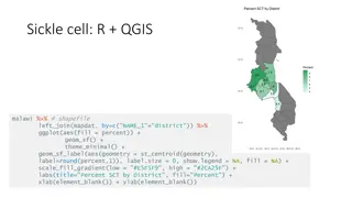
Geographic Data Visualization in R and QGIS for Malawi Health Analysis
Utilizing R and QGIS, this project focuses on visualizing sickle cell and HIV percentages by district in Malawi, mapping health facility locations, creating Voronoi polygons, and displaying malaria cumulative incidence data. Various geographic data visualization techniques are applied to provide ins
0 views • 8 slides
Integrating Geographic Data with BI Dashboards for Strategic Insights
Explore the transformative potential of integrating geographic data into BI dashboard tool for strategic insights in our latest blog. Dive deep into the process\u2014from defining precise objectives and meticulous data collection to expert dashboard
0 views • 13 slides
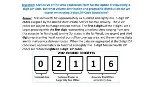
Geographic Distribution Using 3-Digit ZIP Codes
Massachusetts has approximately 685 5-digit ZIP codes assigned by the USPS, which can be aggregated into 18 3-digit ZIP codes for geographic analysis. The distribution of Emergency Department visit volumes varies across these 3-digit ZIP code boundaries, reflecting different regional characteristics
1 views • 4 slides
Distributed Algorithms for Leader Election in Anonymous Systems
Distributed algorithms play a crucial role in leader election within anonymous systems where nodes lack unique identifiers. The content discusses the challenges and impossibility results of deterministic leader election in such systems. It explains synchronous and asynchronous distributed algorithms
2 views • 11 slides
GAC Working Group on Geographic Names Protection in New gTLD Expansion
The GAC Working Group is focused on improving protections for geographic names in future gTLD expansions. They aim to develop practical options and rules to reduce uncertainties for governments, communities, and applicants using geographic or community names. The group seeks to engage local communit
3 views • 27 slides
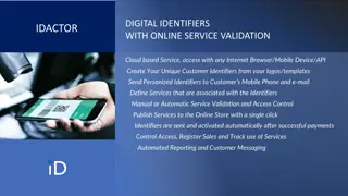
Streamlining Customer Service Management with Digital Identifiers
Revolutionize your customer service experience by leveraging cloud-based digital identifiers for unique customer identification, service validation, and access control. Seamlessly create, personalize, and send identifiers to customers via mobile and email, enabling automated service activation post-
0 views • 15 slides
Data Linkages for DaVINCI
Explore the intricacies of patient identifier linkages and linking methodologies for direct care data in the context of DaVINCI. Learn about different systems such as CHCS, AHLTA/CDR, MHS Genesis, and how they utilize identifiers like EDIPN, SSN, and more to establish unique patient records. Discove
0 views • 29 slides
Unveiling the Realities of Privacy in App Usage
Exploring the complexities of privacy policies, the disclosure of user data by apps, and the implications of mobile tracking. Learn how AppCensus assists parents in understanding app data collection practices and the risks associated with sharing persistent identifiers. Discover how third parties ut
0 views • 25 slides
Exposing the Myth of Misinformation Through Geography and GIS
Geography and Geographic Information Systems play a crucial role in debunking the myths of misinformation. Dr. Barry Wellar discusses the impact of misinformation, highlighting the importance of geographic data in transforming information and knowledge. The presentation delves into the reasons behin
0 views • 17 slides
Framework for Research Data Management and Persistent Identifiers at Waipapa Taumata Rau
This research delves into the integrated framework for Research Data Management (RDM) and the initiatives around Persistent Identifiers (PIDs) and ORCID implementation at Waipapa Taumata Rau. It explores the background, aims, and priorities of the RDM Programme for 2022-2024, focusing on improving R
0 views • 9 slides
Geographic Information Systems: GIS in Statistics and INSPIRE Reporting Obligations
This document outlines the agenda and practical details for a GIS workshop focusing on statistical production and data processing related to geographic information systems. It includes sessions on population gridded data production, automation processes, and practical exercises. Participants from va
2 views • 5 slides
Geographic Data Analysis in Health Statistics Conference
The 2010 National Conference on Health Statistics explored the use of restricted data at the National Center for Health Statistics Research Data Center. The presentation delved into the types of data requested, including small geographic areas, sensitive information, mortality files, and genetic dat
0 views • 45 slides
Overview of the U.S. Federal Statistical System and Census Geography
The U.S. Federal Statistical System comprises 13 principal statistical agencies responsible for collecting and analyzing data across various sectors. The system includes agencies like the Bureau of Economic Analysis, Bureau of Labor Statistics, and U.S. Census Bureau. Geographic identifiers (GEOIDs
0 views • 94 slides
Geographic Concepts Explained with Visuals
Explore various geographic concepts such as time zones, latitude, albedo, environmental spheres, and interactions between spheres through informative images and descriptions. Topics include longitude measurements, Tropic of Cancer location, hemispheres identification, time zone differences, environm
0 views • 34 slides
Health Plan Identifiers: HPID vs. OEID
Health Plan Identifiers (HPIDs) play a crucial role in the healthcare industry by uniquely identifying health plans during electronic transactions. This article delves into the significance of HPIDs, the distinction between Controlling Health Plans (CHP) and Subhealth Plans (SHP), and the comparison
0 views • 17 slides
Meeting the Challenge of Diabetes in China: Prevalence, Trends, and Geographic Variances
This comprehensive study examines the prevalence, trends, and geographic variances of diabetes in China compared to the United States. With a focus on diabetes and prediabetes rates, the analysis spans over two decades, highlighting the significant burden of the disease in the Chinese population. Th
1 views • 24 slides
Naming Systems in Distributed Systems
Entities in distributed systems are uniquely identified using names, addresses, and identifiers. Naming systems assist in name resolution and can be categorized into flat, structured, and attribute-based naming. Flat naming uses random strings as identifiers, and various mechanisms such as broadcast
0 views • 21 slides
Key Concepts in AP Computer Science A Exam Review
Essential topics covered in AP Computer Science A Exam include identifiers, primitive data types, number representation, final variables, and arithmetic operators. Recognizing the basics, such as types, identifiers, operators, and control structures, is crucial for success in the exam. Understanding
0 views • 100 slides
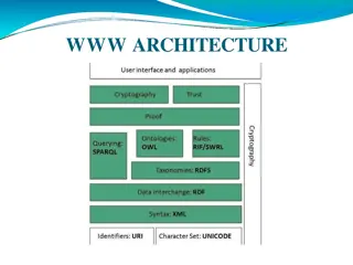
Web Technologies: From Identifiers to FTP
Explore the world of web technologies from identifiers and character sets to data interchange frameworks and ontologies like OWL. Learn about semantic web layers, cryptography, and FTP protocol objectives. Discover how these technologies work together to create a seamless online experience.
0 views • 72 slides
B2HANDLE: Managing Digital Object Identifiers for Data Persistence
B2HANDLE is a service for minting and managing persistent identifiers (PIDs) to facilitate common operations on digital objects across infrastructures. The system enables automated management of data objects and metadata, facilitates machine-driven workflows, and supports the construction of PID and
0 views • 17 slides
Persistent Identifiers (PIDs) and Handling Digital Objects
Explore the significance of Persistent Identifiers (PIDs) in assigning unique identifiers to digital objects, ensuring reproducibility, and facilitating reliable data management. Learn about versioning, PID binding, strategies for assigning PIDs, and the evolving role of repositories in managing dig
0 views • 6 slides
Persistent Identifiers (PIDs) in Research and Data Management
Persistent Identifiers (PIDs) play a crucial role in establishing long-lasting digital references for objects, contributors, and organizations in the realm of research and data management. This introduction delves into the significance of PIDs, focusing on their role in identifying and connecting di
0 views • 13 slides
Recommendations for Creating Identifiers in Data Catalogues
National data catalogues have specific requirements for identifiers, such as using HTTP URIs for open data datasets. While most INSPIRE datasets only have UUID identifiers, adhering to the DCAT-AP standard recommends using HTTP URIs. Recommendations for creating identifiers in the geodata sector are
0 views • 5 slides
Data Modeling: Key Concepts and Applications
Explore the fundamentals of data modeling through concepts like entities, attributes, identifiers, and their real-world applications, including examples related to Greta Garbo, modeling reality, and global legal entity identifiers. Discover how to design data models for diverse scenarios, such as re
0 views • 57 slides
Piloting Unique Identifiers for Geospatial Data - Nordic Forum Presentation
Presentation at the Nordic Forum for Geography and Statistics on piloting unique identifiers for geospatial data by Tuuli Pihlajamaa. The agenda included terms used, background for the pilot, aims, results, and future plans. Detailed discussions on terms like URI, RDF, JHS 193, INSPIRE guidelines, a
0 views • 15 slides
Protecting Password Identifiers in IEEE 802.11-21
This submission addresses the need for safeguarding password identifiers in SAE to ensure privacy and prevent attackers from constructing personally identifiable information. The document presents two potential solutions, ultimately recommending the use of symmetric cryptography for efficient protec
0 views • 11 slides
Submarine Cable Resiliency Report Update - September 2016
This update presents the final findings of Working Group 4A on Submarine Cable Resiliency, focusing on the importance of coordinating federal, state, and local agencies to mitigate risks to submarine cable infrastructure. The report highlights the critical role of regulatory coordination and geograp
0 views • 11 slides
Submarine Cable Resiliency Update and Recommendations
Working Group 4A provides updates on the status of submarine cable resiliency, highlighting the risks to infrastructure due to lack of coordination across agencies and clustering of cable routes. The group aims to enhance regulatory coordination and promote geographic diversity to ensure network res
0 views • 7 slides
Discovering Alabama's Geography: A 4th Grade History Lesson
Explore the geographic regions of Alabama and learn about its history, economy, and political landscape in this 4th-grade history lesson. Students will identify the state's border states, major geographic provinces, and natural resources through thematic maps and interactive activities.
0 views • 19 slides
Geographic Support System Initiative (GSS-I) Overview
The Geographic Support System Initiative (GSS-I) aims to enhance address data quality through partnerships with tribal, state, county, and local governments. This program involves acquiring, verifying, and geocoding address data, with a focus on improving address coverage and spatial accuracy. Reeng
0 views • 20 slides


