Understanding Procedural Knowledge in Geography Education
Procedural knowledge in geography education involves developing geographical skills such as map reading, fieldwork, and enquiry. It focuses on how students gather, analyze, present, and interpret spatial information using tools like globes, atlases, and maps. This knowledge is essential for students to understand locational concepts, climate zones, land use, and more, through activities like fieldwork, mapping, and data analysis.

Download Presentation

Please find below an Image/Link to download the presentation.
The content on the website is provided AS IS for your information and personal use only. It may not be sold, licensed, or shared on other websites without obtaining consent from the author. Download presentation by click this link. If you encounter any issues during the download, it is possible that the publisher has removed the file from their server.
E N D
Presentation Transcript
Thinking about procedural Knowledge Paula Owens Paula Owens 2024
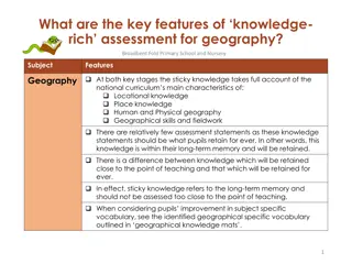
What is meant by procedural knowledge? = Geographical skills and how to use them In geography we use maps to talk about and show where places are and what they are like. Includes skills of fieldwork, mapwork and enquiry. Planning for these skills helps ensure progression. Procedural knowledge (the knowledge of how to use geographical skills) was rarely planned for in the same way as substantive knowledge (established facts about the world). (Ofsted 2023) Pupils procedural knowledge (geographical skills) allows them to gather, analyse, present and interpret spatial information. (Ofsted 2021) Image: paula Owens Paula Owens 2024
Locational Knowledge Year 1 Year 2 Year3 Year 4 Year 5 Year 6 North and South Poles, Equator. Name & locate: 7 continents & 5 oceans. Name, locate, identify: 4 countries and capitals of UK & surrounding seas. Latitude, longitude, Equator, N. & S. hemispheres, Tropics Cancer & Capricorn, Arctic and Antarctic Circle, Prime / Greenwich Meridian & time zones. Locate world's countries, Europe, (including location of Russia), Americas, concentrating on regions, key physical and human characteristics, countries, major cities. Counties, cities, geographical regions, characteristics, topographical features, land use & changes over time. Geographical similarities and differences: human and physical geography of a region of the United Kingdom, a region in a European country, and a region within North or South America Describe and understand key aspects of: Climate zones, biomes, vegetation belts, rivers, mountains, volcanoes, earthquakes, water cycle; Types of settlement & land use, economic activity, trade links, distribution of natural resources: energy, food, minerals, water cycle. Use maps, atlases, globes and digital/computer mapping, 8 compass points, 4 & 6 fig GRs. Use fieldwork to observe, measure, record and present the human and physical features in the local area using a range of methods, including sketch maps, plans and graphs, and digital technologies. (National curriculum DfE 2013) Local scale study UK & Non - European country Place context Identify seasonal & daily weather patterns (UK & local scales) Identify hot & cold areas of the world in relation to Equator & North & South Poles use world maps, atlases and globes, 4 compass points, NSEW, locational language, use aerial photographs and plan perspectives, simple fieldwork and observational skills. Human & physical processes SKILLS Procedural knowledge is knowing how to select, use and apply geographical skills across all contexts of learning. E.g. to learn about the north and south poles children need to learn to use a compass, globe, maps, atlases, do fieldwork and develop appropriate geographical vocabulary. They can do this in the context of local places through fieldwork when learning about the weather, and in the context of more distant places, through globes, maps and atlases when learning about hot and cold places. Paula Owens 2024
Some ingredients of Procedural Knowledge Using globes, atlases, world maps, OS maps, GIS Using compasses Observing Using and making maps, images, diagrams, film media, charts, aerial views FIELDWORK GRAPHICACY Taking photographs, sketching Geographical vocabulary Questioning Critical thinking ENQUIRY Data collection and techniques Analysing and evaluating communicating Paula Owens 2024