Key Features of Knowledge-Rich Assessment in Geography at Broadbent Fold Primary School
Broadbent Fold Primary School emphasizes sticky knowledge in geography assessment, focusing on locational knowledge, place knowledge, human and physical geography, and geographical skills. Assessment statements are designed to ensure long-term retention of key geographical concepts in students' memory, with specific vocabulary identified for each key stage. The curriculum includes topics such as identifying countries, continents, oceans, and physical features, as well as developing basic map-reading and fieldwork skills.
- Geography assessment
- Knowledge-rich approach
- Sticky knowledge
- Broadbent Fold Primary School
- Geographical skills

Download Presentation

Please find below an Image/Link to download the presentation.
The content on the website is provided AS IS for your information and personal use only. It may not be sold, licensed, or shared on other websites without obtaining consent from the author. Download presentation by click this link. If you encounter any issues during the download, it is possible that the publisher has removed the file from their server.
E N D
Presentation Transcript
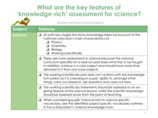
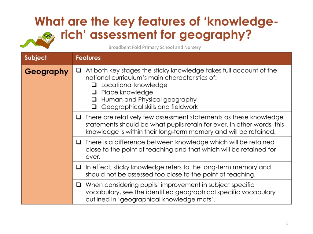
What are the key features of knowledge- rich assessment for geography? Broadbent Fold Primary School and Nursery Subject Features Geography At both key stages the sticky knowledge takes full account of the national curriculum s main characteristics of: Locational knowledge Place knowledge Human and Physical geography Geographical skills and fieldwork There are relatively few assessment statements as these knowledge statements should be what pupils retain for ever. In other words, this knowledge is within their long-term memory and will be retained. There is a difference between knowledge which will be retained close to the point of teaching and that which will be retained for ever. In effect, sticky knowledge refers to the long-term memory and should not be assessed too close to the point of teaching. When considering pupils improvement in subject specific vocabulary, see the identified geographical specific vocabulary outlined in geographical knowledge mats . 1
Geography: Key Stage 1 Place Knowledge Locational Knowledge Skills and Fieldwork Human and Physical Geography name, locate and identify characteristics of the four countries and capital cities of the United Kingdom and its surrounding seas name and locate the world s seven continents and five oceans understand geographical similarities and differences through studying the human and physical geography of a small area of the United Kingdom, and of a small area in a contrasting non-European country Use world maps, atlases and globes Use simple compass directions Use aerial photos, construct simple maps Undertake simple fieldwork within school locality identify seasonal and daily weather patterns in the United Kingdom and the location of hot and cold areas of the world in relation to the Equator and the North and South Poles use basic geographical vocabulary to refer to: beach, cliff, coast, forest, hill, mountain, sea, ocean, river, soil, valley, vegetation, season and weather city, town, village, factory, farm, house, office, port, harbour and shop Know the names of the four countries that make up the UK and name the three main seas that surround the UK Know the name of and locate the four capital cities of England, Wales, Scotland and Northern Ireland Know features of hot and cold places in the world Know where the equator, North Pole and South Pole are on a globe Know which is the hottest and coldest season in the UK Know and recognise main weather symbols Know the main differences between city, town and village Know which is N, E, S and W on a compass Know their address, including postcode Year 1 Know the names of and locate the seven continents of the world Know the names of and locate the five oceans of the world Know the main differences between a place in England and that of a small place in a non-European country Identify the following physical features: mountain, lake, island, valley, river, cliff, forest and beach Explain some of the advantages and disadvantages of living in a city or village. Know and use the terminologies: left and right; below, next to Year 2 2
Geography: Key Stage 2 Locational Knowledge locate the world s countries, using maps to focus on Europe (including the location of Russia) and North and South America, concentrating on their environmental regions, key physical and human characteristics, countries, and major cities name and locate counties and cities of the United Kingdom, geographical regions and their identifying human and physical characteristics, key topographical features (including hills, mountains, coasts and rivers), and land-use patterns; and understand how some of these aspects have changed over time identify the position and significance of latitude, longitude, Equator, Northern Hemisphere, Southern Hemisphere, the Tropics of Cancer and Capricorn, Arctic and Antarctic Circle, the Prime/Greenwich Meridian and time zones (including day and night) Know the names of and locate at least eight European countries Know the names of and locate at least eight counties and at least six cities in England Know the names of four countries from the southern and four from the northern hemisphere Year 3 Know the names of and locate at least eight major capital cities across the world Know where the main mountain regions are in the UK Know, name and locate the main rivers in the UK Know where the equator, Tropic of Cancer, Tropic of Capricorn and the Greenwich Meridian are on a world map Know what is meant by the term tropics Year 4 Know the names of a number of European capitals Know the names of, and locate, a number of South or North American countries Year 5 Know about time zones and work out differences Year 6 3
Geography: Key Stage 2 Human and Physical Geography Place Knowledge understand geographical similarities and differences through the study of human and physical geography of a region of the United Kingdom, a region in a European country, and a region within North or South America describe and understand key aspects of physical geography, including: climate zones, biomes and vegetation belts, rivers, mountains, volcanoes and earthquakes, and the water cycle describe and understand key aspects of human geography, including types of settlement and land use, economic activity including trade links, and the distribution of natural resources including energy, food, minerals and water Know at least five differences between living in the UK and a Mediterranean country Know what causes an earthquake Label the different parts of a volcano Year 3 Know and label the main features of a river Know the name of and locate a number of the world s longest rivers Know the names of a number of the world s highest mountains Explain the features of a water cycle Know why most cities are located by a river Year 4 Know key differences between living in the UK and in a country in either North or South America Know what is meant by biomes and what are the features of a specific biome Label layers of a rainforest and know what deforestation is Year 5 Know the names of and locate some of the world s deserts Know why industrial areas and ports are important Know main human and physical differences between developed and third world countries Year 6 4
Geography: Key Stage 2 Geographical skills and fieldwork use maps, atlases, globes and digital/computer mapping to locate countries and describe features studied use the eight points of a compass, four and six-figure grid references, symbols and key (including the use of Ordnance Survey maps) to build their knowledge of the United Kingdom and the wider world Use maps to locate European countries and capitals. Know and name the eight points of a compass Year 3 Use maps and globes to locate the equator, the Tropics of Cancer and Capricorn and the Greenwich Meridian Know how to plan a journey within the UK, using a road map Year 4 Know how to use graphs to record features such as temperature or rainfall across the world Year 5 Use Google Earth to locate a country or place of interest and to follow the journey of rivers, etc. Know what most of the ordnance survey symbols stand for Know how to use six-figure grid references Year 6 5
Sticky Knowledge: Geography Year 1 Year 2 Know the names of the four countries that make up the UK and name the three main seas that surround the UK Know where the equator, North Pole and South Pole are on a globe Know which is N, E, S and W on a compass Know the names of and locate the seven continents of the world Know the names of and locate the five oceans of the world Know the name of and locate the four capital cities of England, Wales, Scotland and Northern Ireland Identify the following physical features: mountain; lake; island: valley: river; cliff; forest and beach Know the main differences between a place in England and that of a small place in a non-European country Know and use the terminologies: left and right; below and next to Explain some of the advantages and disadvantages of living in a city or village. Know features of hot and cold places in the world Know which is the hottest and coldest season in the UK Know and recognise main weather symbols Know the main differences between city, town and village Know their address, including postcode 6
Sticky Knowledge: Geography Year 3 Year 4 Know the names of, and locate, at least eight European countries Use maps to locate European countries and capitals. Know the names of, and locate, at least eight counties and at least six cities in England Know the names of four countries from the southern and four from the northern hemisphere Know at least five differences between living in the UK and a Mediterranean country Know what causes an earthquake Know where the equator, tropic of Cancer, Tropic of Capricorn and the Greenwich meridian are on a world map Know what is meant by the term topics Know and label the main features of a river Know why most cities are located by a river Know the name of, and locate, a number of the world s longest rivers Know the names of a number of the world s highest mountains Explain the features of a water cycle Label the different parts of a volcano Know how to plan a journey within the UK, using a road map 7
Sticky Knowledge: Geography Year 5 Year 6 Know the names of a number of European capitals Know the names of, and locate, a number of South or North American countries Label layers of a rainforest Know what most of the ordnance survey symbols stand for Know how to use six-figure grid references Know why are industrial areas and ports are important Know main human and physical differences between developed and third world countries Know about time zones and work out differences Know what deforestation means Know what is meant by biomes and what are the features of a specific biome Know how to use graphs to record features such as temperature or rainfall across the world Know the names of and locate some of the world s deserts Use Google Earth to locate a country or place of interest and to follow the journey of rivers, etc. 8