Radar Attenuation Tomography for Mapping Englacial Temperature Distributions
Radar Attenuation Tomography is used to map the temperature distributions within the ice sheet by analyzing the radio waves' attenuation properties. This study focuses on the Eastern Shear Margin of Thwaites Glacier, where fast-moving ice meets slower ice, impacting ice rheology influenced by temperature variations. The research aims to understand the evolution of the glacier margin and its interaction with surrounding structures, such as thermal influences on the bed properties like the presence of water. Airborne radio-echo sounding and ground-based surveys are employed to detect attenuation anomalies, providing insights into the glacier's dynamics and potential impacts of temperature changes.
- Radar Attenuation Tomography
- Englacial Temperature Distributions
- Thwaites Glacier
- Ice Rheology
- Glacier Dynamics

Download Presentation

Please find below an Image/Link to download the presentation.
The content on the website is provided AS IS for your information and personal use only. It may not be sold, licensed, or shared on other websites without obtaining consent from the author. Download presentation by click this link. If you encounter any issues during the download, it is possible that the publisher has removed the file from their server.
E N D
Presentation Transcript
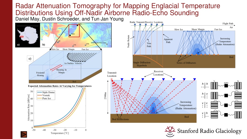
Radar Attenuation Tomography for Mapping Englacial Temperature Distributions Using Off-Nadir Airborne Radio-Echo Sounding Daniel May, Dustin Schroeder, and Tun Jan Young
Radar Attenuation Tomography for Mapping Englacial Temperature Distributions Using Off-Nadir Airborne Radio-Echo Sounding Daniel May, Dustin Schroeder, and Tun Jan Young
Radar Attenuation Tomography for Mapping Englacial Temperature Distributions Using Off-Nadir Airborne Radio-Echo Sounding Daniel May, Dustin Schroeder, and Tun Jan Young
Radar Attenuation Tomography for Mapping Englacial Temperature Distributions Using Off-Nadir Airborne Radio-Echo Sounding Daniel May, Dustin Schroeder, and Tun Jan Young
Radar Attenuation Tomography for Mapping Englacial Temperature Distributions Using Off-Nadir Airborne Radio-Echo Sounding Daniel May, Dustin Schroeder, and Tun Jan Young
Radar Attenuation Tomography for Mapping Englacial Temperature Distributions Using Off-Nadir Airborne Radio-Echo Sounding Daniel May, Dustin Schroeder, and Tun Jan Young
Radar Attenuation Tomography for Mapping Englacial Temperature Distributions Using Off-Nadir Airborne Radio-Echo Sounding Daniel May, Dustin Schroeder, and Tun Jan Young Airborne RES Data From Thwaites Glacier Context: Thwaites Glacier Eastern Shear Margin Off-Nadir Radio-Echo Sounding Ground-Based Bistatic Surveys Expected Attenuation Rate Anomalies
Context: Eastern Shear Margin of Thwaites Glacier Eastern Shear Margin Fast ice meets slow ice: shear heating Ice rheology influenced by temperature Study evolution of margin: boundary not controlled by topography Constrain bed properties: presence of water? Young, 2021
Estimating Englacial Attenuation at Eastern Shear Margin Nadir-Only Methods Rely on large spatial variations in ice thickness May need 100s of km to estimate attenuation rate Perform poorly near shear margins and grounding zones Only depth averaged estimates with low spatial resolution Modeled vs Estimated Attenuation (Derived From Nadir Returns) Nadir-Only RES Geometry Schroeder, 2016
Off-Nadir Radio-Echo Sounding Geometry Airborne RES data are collected with zero-offset between transmitter and receiver (monostatic) Backscattered energy still recorded from ground locations not directly below radar (off-nadir) Returned power decreases with increasing attenuation rate, path length in ice, and incidence angle Diversity of ray lengths and incidence angles used to estimate attenuation rates within shear margin
Off-Nadir Radio-Echo Sounding Geometry Path Diversity: Off-Nadir vs Nadir Only Benefit of Off-Nadir Returns Significant variation in path length over few kilometers (even hundreds of meters) in areas of constant ice thickness Ice paths significantly vary in directionality: infer vertical changes in attenuation rates Confounding factor: angular dependence of bed return power Limited geometry control compared to ground-based methods But: lots of available airborne data (easier than collecting ground-based profiles) PASIN and PASIN2 Airborne RES Lines British Antarctic Survey, 2023
Expected Anomalies: Radio Wave Attenuation and Ice Temperature Temperature Inferred From Attenuation Attenuation of radio waves highly dependent on ice temperature Small lateral but significant vertical temperature anomalies expected within shear margins Temperate ice may exist throughout significant fraction of ice column at margins Meyer, 2018 Suckale, 2014
Expected Anomalies: Initial Modeling Modeling Expected Attenuation Consider single, monostatic observation Simplified attenuation rate profile Assume isotropic scattering at bed and specular layer reflections Attenuation integrated over paths from dipping layers and bed scatterers Need to consider next: effects of diffuse bed scattering and non- uniform layer reflectivity
Data Processing: Time-Wavenumber Domain Spatial Fourier Transform Specular layers Narrow Doppler signature Bed Hyperbolas Average Bed Hyperbola Basis of attenuation tomography: Energy along bed hyperbola in time- wavenumber domain can be mapped to along track location: Doppler wavenumber gives insight into propagation angle.
Data Processing: Power Drop With Wavenumber Processing in Wavenumber Domain Wavenumber related to lateral distance between sounder and origin of energy For uniform temperature ice column, tomography not needed, but effects of scattering still need to be considered Complex attenuation profile: assign bed power to associated travel paths and use straight ray reflection tomography.
Ground-Based Polarimetric Surveys: Motivation Planned Ground-Based Surveys Bistatic radar system with theoretically unlimited offset use active seismic survey geometries Polarimetric survey constrains bed materials separate attenuation from reflectivity Greater control on raypath geometry More labor intensive than collecting airborne data Young, 2021 Bienert, 2022
Ground-Based Polarimetric Surveys: Radar System Without cable, extra processing required to phase align repeated chirps before coherent summation: Bienert, 2022
Intermediate Processing Step: Downward Continuation Redatuming Motivation Get rid of uninteresting air layer Simplify raypaths: Doppler information now related to angle of propagation in the ice only No need to calculate refraction points along surface (which has no analytical solution, inefficient). More efficiently implement 2D and 3D imaging techniques for improved geometry constraints (e.g., migration)