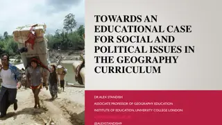
Geography Curriculum Intent and Vision for Whole School Development
The Geography curriculum is designed to engage students in acquiring knowledge, developing critical skills, and fostering a sense of global citizenship. The focus is on enjoying learning, building vocabulary, effective communication, and problem-solving. The curriculum progresses from KS3 to GCSE, emphasizing key themes and skills essential for students to become competent geographers. The vision includes creating proactive global citizens who contribute positively to sustainability. Key concepts such as location, development, scale, and interdependence are integrated to promote a deeper understanding of the subject.
- Geography curriculum
- Whole school development
- Knowledge acquisition
- Global citizenship
- Critical skills

Download Presentation

Please find below an Image/Link to download the presentation.
The content on the website is provided AS IS for your information and personal use only. It may not be sold, licensed, or shared on other websites without obtaining consent from the author. Download presentation by click this link. If you encounter any issues during the download, it is possible that the publisher has removed the file from their server.
E N D
Presentation Transcript
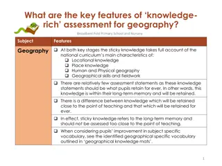
Curriculum Intent Subject Geography PRIORITIES IN WHOLE SCHOOL CURRICULUM INTENT KEY QUESTIONS TO CONSIDER Enjoyment of learning Knowledge acquisition and recall Extensive vocabulary Effective communication through writing, speaking & listening, and use of technology Numeracy Critical evaluation of information Enterprise and problem-solving Working with others 1. Why has content been selected? Is there sufficient focus on the most powerful knowledge, concepts and skills? 2. Does learning provide sufficient challenge? Is there sufficient challenge for all learners in all year groups? 3. Why is learning sequenced in this way? Does the sequence enable students to build on prior learning, and learn in increasing breadth and depth over time? 4. How is learning sequenced or spaced to promote long-term memory? HOW IS THE EXTENDED TIME IN KS4 USED TO IMPROVE & ENRICH LEARNING IN THE SUBJECT? SUBJECT CURRICULUM INTENT The KS3 curriculum is designed to fulfil the requirements of the National Curriculum. It teaches a number of physical and human themes across various regions of the world. It is intended to prepare students for the GCSE course and borrows a lot of similar themes from these e.g. tectonics. Exam technique and command words are addressed early on, also in preparation for the GCSE course. It is intended that students have a sense of where they are in the world, and why various physical and human processes occur, in order to foster an enquiring and questioning mind, whilst also analysing the problems the world faces. In KS4, we spend Y10 and 11 delivering the entire AQA GCSE course. There are also opportunities to work and refine exam technique through stringent approaches to exam questions. This, coupled with DTT, is designed to improve students ability to access and respond to the GCSE questions in the exam
Vision and Key Concepts Vision Our shared department vision is that every student should leave Bedford as competent geographers. Within this they will become globalcitizens where they are proactive in their part in making the world a more sustainable place, and contribute to this in a positive way regardless of aptitude or socio-economic background. Students will embed skills that enable them to be critical thinkers to analyse data, adapt to varying situations and implement them in a positive way. Location A specific place on the earths surface, given meaning by people, but the meanings may differ. Development The process where an area undergoes a positive change be it social, economic or environmental. Scale Covers the local, regional, national and global aspects of a physical and human geography. Economic Relating to the wealth of an area Environment Living and non-living surroundings at a particular scale. Social Relating to people and communities Physical The area of geography that relates to the natural world Interdependence Positive and negative relationships between people and/or the environment. Human The areas of geography that relates to the built environment. Change Observing differences in the geographical world over time. Can relate to both physical and human changes. Cultural Awareness and Diversity - systems that recognise and respect the existence and presence of diverse groups of people within a society Sustainability Meeting the needs of the present without compromising the needs of future generations. These Key Concepts form Essential Knowledge throughout the whole of curriculum and are visited in a number of places, themes and scales
YEAR 7 FUTURE DEVELOPMENT + PERSONAL DEVELOPMENT SMCMP, PSHE, CAREERS To follow the change in GCSE curriculum, the interpretation of relief on OS maps will be developed. Development of this topic could include real life interpretation of OS maps in the local area. KNOWLEDGE CONCEPTS SKILLS RATIONALE Location Scale Environment - Scale and direction to measure straight line distances and curved routes on a map Compass points all 8 point, some 16. Understanding of 4 and 6 figure grid references to located features on a map. This will incorporate OS map symbols. - This is taught as the first unit to provide a basic understanding of the fundamental geographical skills used throughout all topics in KS3 and KS4.These will be revisited when appropriate to support teaching and learning of the unit. - Map Skills - To know the differences between physical and human geography - To know the continents and oceans of the world. This includes major lines of latitude and longitude - To know the physical and human features of the British Isles, including the location of major cities, mountain ranges and rivers. Africa - To understand certain countries and physical features of Africa, including the region of the Horn of Africa. - To locate the biomes of Africa and their individual characteristics. - To focus on a specific biome, hot deserts. Characteristics include location, climate, plant and animal adaptations, and o know the location of human adaptability. - - - - Careers MYPATH job of the week town planner https://www.youtube.com/w atch?v=yivBYbGad0A Term 1 - - - - - - Location Scale Environment Interaction Change Sustainability - Field sketch drawings and annotations. Reading and interpreting choropleth maps. Africa is taught to extend students location knowledge and deepen their spatial awareness of the world countries using maps of the world to focus on Africa. This focuses on their environmental regions including hot deserts, key physical and human characteristics, countries and major cities (as dictated by the KS3 National Curriculum). Lessons are taught in an order which initially focuses on the continent as a whole, but then hones in on specific human and physical aspects in line with the national curriculum. - Information and media used throughout lessons should be kept relevant and up to date. To allow the topic some flexibility to incorporate recent developments and current news e.g. famine, conflicts, droughts in South Africa. SMSC Cultural development to form an appreciation of different cultures including the nomadic way of life. - - -
YEAR 7 FUTURE DEVELOPMENT + PERSONAL DEVELOPMENT SMCMP, PSHE, CAREERS Information and media used throughout lessons should be kept relevant and up to date. To allow the topic some flexibility to incorporate recent developments and current news e.g. famine, conflicts, droughts in South Africa. KNOWLEDGE CONCEPTS SKILLS RATIONALE - - - - - - Location Scale Environment Interaction Change Sustainability - - - Comparing Data Map Skills Climate Graphs To understand geographical similarities, differences, and links between places through the study of physical and human geography of a region within Africa (as dictated by the KS3 national curriculum) - Africa Continued - Horn of Africa Introduction Horn of Africa- Physical Horn of Africa- Drought Horn of Africa- Climate Horn of Africa- Coffee Horn of Africa- Nomads Horn of Africa - Addis Ababa - - - - - - - Term 2 - - - - - Location Scale Environment Interaction Change - - - Map Skills Climate Graphs Choropleth Maps Lessons are taught in this order to locational knowledge and deepen their spatial awareness of Russia, focusing on environmental regions, key physical and human characteristics, and major cities. As dictated by the KS3 national curriculum. - Future developments will include glaciation. This includes landforms, processes and human impact. SMSC Cultural understanding to have an appreciation of differences in urban and rural dwellers in Russia Russia - Introduction - Physical Geography of Russia - Climate of Russia - Vegetation of Russia - Population of Russia -
YEAR 7 FUTURE DEVELOPMENT + PERSONAL DEVELOPMENT SMCMP, PSHE, CAREERS Future developments will include glaciation. This includes landforms, processes and human impact. KNOWLEDGE CONCEPTS SKILLS RATIONALE - - - - - Location Scale Environment Interaction Change - - - Comparing population Map Skills Choropleth Maps Lessons are taught in this order to locational knowledge and deepen their spatial awareness of Russia, focusing on environmental regions, key physical and human characteristics, and major cities. As dictated by the KS3 national curriculum. - Russia Continued - Rural Vs Urban - Natural Resources - Chernobyl a Nuclear Disaster - To understand the physical processes involved in the formation of fluvial landforms. To also highlight human uses for rivers as well as their impacts. Contrast the effects of flooding in a LIC and a HIC. Students will also assess methods of managing and reducing flooding. - - Map Skills Analyzing river processes Use of drawings/field sketches of landforms. - This is taught towards the end of Year 7 where GCSE subject content will be more accessible after a full year of KS3 Lessons are taught to highlight the impacts of hydrology(As dictated by the KS3 National Curriculum for Geography) on the physical landscape as well as their affects on human activity. Acts as a foundation topic for Unit 1C of the AQA GCSE Geography specification (UK Physical Landscapes) - Add in coasts to fulfil the further requirements of the GCSE specification. Rivers need to update (Amendment needed this topic has moved to Y9) - World Rivers - Water Cycle - Drainage Basin - Course of a River (processes) - Waterfalls and Gorges - Meanders and Oxbow lakes - How do we use rivers? - Why do river flood? - Flooding HIC - Flooding LIC - Managing floods - Reducing flooding Term 3 - -
YEAR 7 FUTURE DEVELOPMENT + PERSONAL DEVELOPMENT SMCMP, PSHE, CAREERS Careers MYPATH job Hotel porter - https://www.youtube.com/ watch?v=rp5ox2mDxjc&lis t=PLVEWa7uIDT769WGU Tc_- lOca4dJRlPatZ&index=8 KNOWLEDGE CONCEPTS SKILLS RATIONALE - - - - - - - - - - Location Scale Environment Change Sustainability Economic Social Physical Human Cultural awareness and diversity - - - Map skills Atlas skills Analysing photos Tourism is taught as it is the world s largest employment sector and is present in almost every country. We will be looking at how the physical and human geography of an area influences the type of tourism that takes place. We will see how the growth of tourism has had social, economic and environmental effects on the UK and other countries. It is important to see how an economic activity influences and is influenced by external factors. We teach it now as it is getting closer to the summer holidays and will help focus and contextualise the unit of work. - Tourism (in place of rivers. - 2022) - What is tourism? - Why do places become a tourist destination? - Is there tourism in the UK? - Are National Parks tourist sites? - Why do people want to visit Antarctica? - Does Kenya need tourism? - What is ecotourism? - Can religion create tourism? - The Maldives paradise forever? - What is space tourism? - How does the media influence tourism? - Australia project - British values tolerance can be discussed when looking at the lesson of religion creating tourism (Catholic and Buddhist faiths) Term 3 - SMSC Cultural and moral development to understand how our actions influence the lives of others through using resources unsustainably e.g. climate change - - - - - Location Scale Environment Physical Human - - - - Fieldwork skills Primary data collection Data presentation Analysis and evaluation skills Students will be given the opportunity to collect primary data outside of the classroom. This data will be manipulated and presented in a form of different graphs. Results will be analysed and conclusions drawn. Evaluation of the fieldwork methods will also be employed. Year 7 Fieldwork Microclimate and environmental quality survey. To be planned for the end of term 3 needs to be adapted and brought in
YEAR 7 KNOWLEDGE CONCEPTS SKILLS RATIONALE FUTURE DEVELOPMENT YEAR 7 ENRICHED LEARNING EXPERIENCES - To plan and implement an element of primary data collection outside of the classroom environment. This data will be used to formulate different presentation techniques which will be analysed as in the GCSE curriculum. This will be brought into term 3
YEAR 8 FUTURE DEVELOPMENT + PERSONAL DEVELOPMENT SMCMP, PSHE, CAREERS Developments will include the addition of more lessons focusing on the middle east and its importance in the global community. KNOWLEDGE CONCEPTS SKILLS RATIONALE - - - - - - - Location Scale Environment Interaction Change Sustainability Processes - - - - - - - Map Skills Choropleth maps Data Analysis Climate Graphs Atlas Skills GDP Comparisons Analysing photos - Lessons are taught in this order to locational knowledge and deepen their spatial awareness of Asia (and the Middle East), focusing on environmental regions, key physical and human characteristics, and major cities. As dictated by the KS3 national curriculum. Asia is the overarching topic in Year 8. A variety of themes are taught e.g. tectonics under the umbrella of Asia. This allows numerous GCSE elements to be taught but with the central focus of the continent of Asia. - Asia - Where is Asia? What countries and regions are in Asia? What are Asia s physical features? How is Asia a diverse continent? Where is India? What is the weather like in India? All of India is poor, right? What is it like to live in a Mumbai slum? What jobs are available in India? (Primary and Secondary Industries) What jobs are available in India? (Tertiary and Quaternary Industries) Where is the Middle East? How does Dubai survive in the desert? Why is everything high in Dubai? What tectonic hazards are in Asia? Will I find volcanoes in Asia? Will I find earthquakes in Asia? How can people prepare for an earthquake? - - - Careers MYPATH job Disaster manager https://www.youtube.com/w atch?v=jFCifuGxgbQ - - - - - Careers MYPATH Geoscientist https://www.youtube.com/w atch?v=TL6EvSZV0vY&list =PLVEWa7uIDT769WGUT c_- lOca4dJRlPatZ&index=32 - - Term 1 - - SMSC Cultural development to form an appreciation of the life of people living in Asia e.g. differences in development and diversity - - - - - - -
YEAR 8 FUTURE DEVELOPMENT + PERSONAL DEVELOPMENT SMCMP, PSHE, CAREERS To allow the topic some flexibility to incorporate recent developments and current news e.g. fires in the Amazon, recent protests on climate change. KNOWLEDGE CONCEPTS SKILLS RATIONALE - - - - - - - Location Scale Environment Interaction Change Sustainability Processes - - - Map Skills Location Data Climate Graphs - Lessons are taught in this order to understand how human and physical processes interact to influence environments and the climate; and how human activity relies on the effective functioning of natural systems in a Tropical Rainforest environment (as dictated by the KS3 national curriculum for Geography. - Rainforests - Location & Climate - Amazon Tribes - Deforestation - Vegetation & Wildlife - Adaptations (design own animal x 3 Lessons) - How can topical rainforest be managed sustainability? Term 2 - SMSC Cultural development to form an awareness of indigenous tribes in the rainforest
YEAR 8 FUTURE DEVELOPMENT + PERSONAL DEVELOPMENT SMCMP, PSHE, CAREERS To allow the topic some flexibility to incorporate recent developments and current news e.g. Riots in Hong Kong, Effects of an aging population as the validity of the one child polity expires. Careers MYPATH job toxicologist https://www.youtube.com/watch? v=Nebp4- SzyrY&list=PLVEWa7uIDT769W GUTc_- lOca4dJRlPatZ&index=43 SMSC cultural development and tolerance looking at China s one child policy and the issues associated with it. Include a contrast of the impacts of future developments in a HIC and a LIC (e.g. Brexit) KNOWLEDGE CONCEPTS SKILLS RATIONALE - - - - - - - Location Scale Environment Interaction Change Sustainability - Population Density Maps Population Distribution Maps Analysing Key issues with the One Child Policy Exam style questions and technique. - Lessons are taught in this order to locational knowledge and deepen their spatial awareness of China key physical and human characteristics, major cities, ethical issues of the one child policy, pollution in Beijing. As dictated by the KS3 national curriculum. China - Introduction - TNC - Population - One Child Policy - Pollution - Three Gorges Dam - Great Wall of China - Superpower - - - - - - Lessons are taught in this order to appreciate feelings about places which are important to the student. We look at how places change over time and how these can be made more sustainable to meet the needs of future generations. Some concepts need deeper thinking hence the reason for appearing towards the end of Y8 - - - - - Location Scale Interaction Change Sustainability - Analysing development indicators Exam style questions and technique. - Place and Space (new 2022) Term 3 What is living space? How do people feel about different living spaces? How do living spcaes change over time? How are places connected? Why do places change? Can a place be placeless? How are places represented in the media? Why do some places go into decline? How can a place be rebranded? How can places be sustainable? How can living spaces be sustainable? - - Careers MYPATH Job Urban planner https://www.youtube.com/ watch?v=nB01lPIVjvk&list =PLVEWa7uIDT769WGU Tc_- lOca4dJRlPatZ&index=20 - Careers MYPATH Job Housing officer https://www.youtube.com/ watch?v=XcCRiJci4dw&lis t=PLVEWa7uIDT769WGU Tc_- lOca4dJRlPatZ&index=33 - Lessons are taught in this order to highlight human geography relating to: international development; economic activity in the primary, secondary, tertiary and quaternary sectors. - This is taught at the end of Year 8 prior to GCSE as higher level analytical skills are required. Development Development Indicators - Uneven Development - Development Categories - Goods and Money - Solving Uneven Development
YEAR 8 FUTURE DEVELOPMENT + PERSONAL DEVELOPMENT SMCMP, PSHE, CAREERS KNOWLEDGE CONCEPTS SKILLS RATIONALE YEAR 8 ENRICHED LEARNING EXPERIENCES - To include some learning opportunities from an external agency. For example, some early ideas include: Rainforest on a bus, geographical speakers, or visiting a local zoo (as part of the tropical rainforest topic). Will Boardman no works for Wigan Council environmental department so could come in to deliver a presentation on air quality (links to China and place and Space sustainability)
YEAR 9 FUTURE DEVELOPMENT + PERSONAL DEVELOPMENT SMCMP, PSHE, CAREERS Developments will include the addition of a case study on differing landscapes as well as additional resources supporting plate tectonics. KNOWLEDGE CONCEPTS SKILLS RATIONALE - - - - - Location Scale Environment Change Processes - - - Map Skills Data Analysis GIS (Unable to complete due to Covid and sharing of computers/tables. Will re-introduce pending further resources.) - Students learn about the geology of the UK to support learning on tectonics, weathering and erosion later in KS3 and in to KS4. Geology can also be linked to any landscape in the world, understanding how these rocks affected the landscape in question is a fundamental geographical skill. Lessons are taught in this order to build knowledge of the geological timescale first and then and explanation of how rocks are formed under a variety of different conditions. This then feeds in to analysing GIS data to show this in the real world and how landscapes influence people, as directed by the KS3 national curriculum. This topic builds on prior knowledge of plate tectonics from Year 8 and feeds in to the challenge of natural hazards in KS4. - Geology - What is Geology? - How old is the planet? - What are the three types of rock? - What is the rock cycle? - Weathering - Rocks and the land scape - GIS - Careers MYPATH Job Wellsite Geologist https://www.youtube.com/w atch?v=4FIZqtindec&list=P LVEWa7uIDT769WGUTc_- lOca4dJRlPatZ&index=22 - - Careers MYPATH Geoscientist https://www.youtube.com/w atch?v=TL6EvSZV0vY&list =PLVEWa7uIDT769WGUT c_- lOca4dJRlPatZ&index=32 Term 1 - Careers MYPATH Job Hydrogeologist https://www.youtube.com/w atch?v=Nebp4- SzyrY&list=PLVEWa7uIDT 769WGUTc_- lOca4dJRlPatZ&index=43 -
YEAR 9 FUTURE DEVELOPMENT + PERSONAL DEVELOPMENT SMCMP, PSHE, CAREERS - Case studies will be added/updated over time. KNOWLEDGE CONCEPTS SKILLS RATIONALE - Location - Scale - Environment - Interaction - Change - Sustainability - Processes - Map Skills - Decision making - Cost benefit analysis. - We will be studying coasts and rivers to see what physical features are formed through the power of water. We will look at how coastal and river processes influence us, and what we can do to manage the effects of flooding. This is all the more relevant due to climate change with the increase in flooding in the UK as one of our biggest hazards and future challenges. - Lessons are taught in this order to lay the foundations of processes first, which is then built upon as students relate these processes to the create of landforms found around the UK. Students will then critically analyse different management strategies and opinions to get an appreciation of how difficult these issues are to manage in the real world. - This unit connects to the next unit on weather and climate. It also links with the unit later on in the year on climate change and global issues. Our responses to flooding and the effects of flooding link with other units studies in Year 8 such as tectonic hazards in Asia. - Rivers and coasts are two of the units that are studied within GCSE Paper 1C Physical landscapes in the UK Coasts and Hydrology - What are waves? - Erosional processes - Erosional landforms - Transportation - Coastal engineering - What should happen to Happisburgh? - Water cycle - Drainage basins - Erosional river landforms - Erosional and depositional landforms - River flooding - River management Term 1
YEAR 9 FUTURE DEVELOPMENT + PERSONAL DEVELOPMENT SMCMP, PSHE, CAREERS GIS will be explored through the use of current weather charts. KNOWLEDGE CONCEPTS SKILLS RATIONALE - - - - - - Location Scale Environment Interaction Change Processes - - - Map Skills Climate Graphs Decision Making - It is important to know and study weather and climate because they affect everyone and everything. They can influence human behaviour, environmental conditions and economic factors. Weather and climate links to most topics in KS3 such as UK geology, coasts and hydrology, Africa, Asia and tropical rainforests. Additionally, this topic has connections with topics from the GCSE Geography specification such as The Challenge of Natural Hazards and The Living World . Lessons are taught in this order give an general overview of differences between weather and climate and ways they are measured. Global scale is looked at first before zooming in to a national and local level. - Weather and Climate - What is the difference between weather and climate? - How do meteorologists measure the weather. - Ho do clouds and rain form? - Why are some places hot and others cold? - What are the earths climate zones? - Why is the UK s climate so unique? - Why does the UK s weather vary? - Will the change in climate impact the UK? - How has the changing climate affected the UK? - What is a microclimate? - Term 2 -
YEAR 9 FUTURE DEVELOPMENT + PERSONAL DEVELOPMENT SMCMP, PSHE, CAREERS To explore virtual fieldwork of an area that has been affected by glacial erosion. KNOWLEDGE CONCEPTS SKILLS RATIONALE - - - - - - Location Scale Environment Interaction Change Processes - - - - Map Skills Photo analysis Cost/benefit analysis Decision making - We will be studying glaciers to see what physical features are formed through the power of ice. We will look at how glacial processes have influence us and landscapes and how this has created both opportunities and conflict in glaciated environments. Lessons are taught in this order to lay the foundations of processes first, which is then built upon as students relate these processes to the create of landforms found around the UK. Student will explore opportunities, particularly tourism, that has formed as a result of glacial processes, and the resulting conflicts that ensue. As directed by the KS3 national curriculum although we have explored the idea of conflict in more depth due to the building of prior knowledge of this during the rivers topic. - Glaciation - How does Ice shape the UK? - How do glaciers move? - How does glacial erosion shape the land? - How does glacial deposition affect the landscape? - How did glaciers affect Cadair Idris? - Economic opportunities in glacial areas? - Conflict in glacial areas? - How has tourism affected the lake district? - Term 2
YEAR 9 FUTURE DEVELOPMENT + PERSONAL DEVELOPMENT SMCMP, PSHE, CAREERS To explore the complexity of GIS and adding multiple forms of this to the unit. KNOWLEDGE CONCEPTS SKILLS RATIONALE - - - - Location Scale Environment Interaction - - Map skills GIS (Unable to complete due to Covid and sharing of computers/tables. Will re-introduce pending further resources.) Data analysis - Crime is studied to allow students to understand the social and economic impacts. Effects of crime are mapped using relevant GIS, students analyse this data and relate it to their own local area. Crime prevention is studied so that students acknowledge practical steps to reduce crime. Crime is investigated at a range of scales and locations to understand the different perspectives. Lessons are taught in this order to give a overarching understanding of crime and mapping, students are able to analyse this data and reach conclusions about crime in their area. This links to the KS4 unit of urban issues and challenges and KS3 where social and economic factors/impacts are studied e.g. Asia and Africa. - Crime - What is crime? - Is one crime more serious than another? - What are the effects of crime? - Where does crime happen? - How can we map crime? - How can we use GIS to target crime? - How can crime be prevented? - Crime on land what is the heroin trail? - Crime at sea What is modern day piracy? - Crime in Japan Why is there an elderly crime wave in Japan? - What were the London riots? - Careers apprenticeships in Geography https://amazingapprentice ships.com/think- apprenticeships-films/ - - British values the rule of law and mutual respect throughout this unit. - SMSC moral developments in terms of the difference between right and wrong throughout the unit. Term 3 - -
YEAR 9 FUTURE DEVELOPMENT + PERSONAL DEVELOPMENT SMCMP, PSHE, CAREERS TUI world detective resources will be studied to enhance learning and added if relevant. KNOWLEDGE CONCEPTS SKILLS RATIONALE - - - - - - Location Scale Environment Interaction Change Sustainability - - - - Map skills Decision making Climate graphs Debate - Climate change is the greatest threat facing the planet today and students look at how climate change has already affected the planet and how it will continue to affect them throughout their lifetimes. We also study the global response to climate change and address the impact of global warming. This unit encourages students to think about how their attitudes and actions impact the planet. Lessons are taught in this order to justify how climate change is a natural process however, accelerated by human activity. We then study the impacts and spend a considerable amount of time on practical mitigation strategies that students could implement to reduce the rate of change. - Climate Change and Global Issues - What is climate change? - Does climate change happen naturally? - How are we causing climate change? - How is climate change impacting us? - How can climate change be managed? - How can climate change be mitigated? - How can we adapt to climate change? - What can we do about climate change? - What do we mean by before the flood? - What is an inconvenient truth? - Careers MYPATH Job Sustainability Consultant https://www.youtube.com/ watch?v=zN5WK1H4VaU &list=PLVEWa7uIDT769 WGUTc_- lOca4dJRlPatZ&index=65 - SMSC moral development forming an opinion on climate change and the ethical reasons for becoming more sustainable Term 3 -
YEAR 9 FUTURE DEVELOPMENT + PERSONAL DEVELOPMENT SMCMP, PSHE, CAREERS KNOWLEDGE CONCEPTS SKILLS RATIONALE YEAR 8 ENRICHED LEARNING EXPERIENCES - To include some aspect of a field study either virtual or in person. Early ideas include study of a glacial environment, or a school study of microclimate. Amendment - For the year 2022-23, these topics will be re-sequenced as the first part of the year is too top heavy in terms of physical geography
YEAR 10 FUTURE DEVELOPMENT + PERSONAL DEVELOPMENT SMCMP, PSHE, CAREERS Developments in the future could relate to the up-to-date integration of hazards as they occur. This should gain the interest of students and improve in the engagement of the subject. KNOWLEDGE CONCEPTS SKILLS RATIONALE Location Scale Environment Interaction Change Sustainability Processes Describing features on maps: General (location) Specific (using place information) Anomalies (areas that do not fit the general trend) We are delivering these units following the AQA GCSE specification. This is the first unit of Paper 1. We begin this unit by looking at different types of hazard. The logical step is then to concentrate on one of these types tectonics. We look at the processes involved in the hazards and how they impact upon people, property and the environment. Again, the rationale for the next step comes by looking at humans react to these hazards immediately and in the long-term. We use case studies (or examples) of these in areas with different levels of development. We then look at how humans can be proactive and mitigate the impacts of these hazards. This is a logical sequence of process impacts examples reactions management. The challenge of Natural Hazards Define a natural hazard and give some examples of the different types. Careers apprenticeships in Geography https://amazingapprenticeships.com/th ink-apprenticeships-films/ Factors that affect risk. Describe the distribution of earthquakes and volcanoes Explain the differences between destructive, constructive and conservative plate margins. Main features of an earthquake and two different ways of measuring earthquakes Using named examples of a tectonic hazard in both rich (Chile) and poor (Nepal) countries Term 1 We repeat this same process for weather hazards and climate change. Describe the global atmospheric circulation model. describe the distribution of tropical storms. describe and explain the primary and secondary impacts of tropical storms identify evidence of the weather becoming more extreme describe and the mitigation and adaptation strategies used to reduce the impact of global climate change on a local, national and international level
YEAR 10 FUTURE DEVELOPMENT + PERSONAL DEVELOPMENT SMCMP, PSHE, CAREERS Developments in the future could relate to the up-to-date integration of any news related to these two biomes (e.g. 2019 Amazon fires) as they occur. This should gain the interest of students and improve in the engagement of the subject CONCEPTS SKILLS RATIONALE KNOWLEDGE Living World Location Scale Environment Interaction Change Sustainability Processes Describing features on maps: - General (location) - Specific (using place information) - Anomalies (areas that do not fit the general trend) - Completing and analysing graphs e.g. climate graphs We are delivering these units following the AQA GCSE specification. This is the second unit of Paper 1. We deliver this by covering the main components of any ecosystem first and how they interact with each other in a small-scale ecosystem in the UK (pond). The next logical step is to increase the scale to a global one and focus on the distribution of biomes. This is then followed by focussing on two biomes (tropical rainforests and hot deserts). TRF is a compulsory component of the unit whereas hot deserts is an option (or cold environments). The rationale behind following the hot deserts part is to build upon knowledge accrued in Y7 when we look at deserts as part of the Africa unit of work. TRF s are also initially studied in Y8 (as part of the Asia unit) so this builds upon previously learnt knowledge. - define and give UK examples of producers consumers, decomposer, food chain, food web and nutrient cycle describe the distribution and characteristics of global ecosystems around the world describe the physical characteristics of the tropical rainforests describe the problems and issues with changing biodiversity within the tropical rainforest and hot deserts Term 2 describe and explain the changing rates of deforestation describe the physical characteristics of the hot desert define and describe desertification
YEAR 10 FUTURE DEVELOPMENT + PERSONAL DEVELOPMENT SMCMP, PSHE, CAREERS Developments in the future could relate to the up-to-date integration of changes to any UK physical landscapes (or hazard relating to these) as they occur. This should gain the interest of students and improve in the engagement of the subject KNOWLEDGE CONCEPTS SKILLS RATIONALE Location Scale Environment Interaction Change Sustainability Processes General descriptions and explanations of a range of figures and data (maps, graphs, etc). We are delivering these units following the AQA GCSE specification. This is the final unit of Paper 1. There is a choice of teaching two smaller units out of three (coasts, rivers, glaciation). We have chosen coasts and rivers. The rationale behind this is that they both share very similar processes in reference to erosion and transportation. Therefore, the knowledge and concept should be more easily transferred between the two. The sequence of both is based on processes, landforms, real examples of these, management of both environments to show how these processes can be reduced and then real examples of these management strategies. - UK Physical landscapes describe the location of the major upland and lowland areas, and major river systems within the UK OS map work based on coasts and rivers. describe the different types of waves Annotated field sketches of photos Describe the processes of erosion, weathering and mass movement on the coast Describe the sequence of erosional landform formation e.g. stacks describe the processes of transportation in the coastal zone Term 3 describe how a rivers long profile and cross profile varies over it s course Describe the processes of erosion, transportation and deposition Describe the sequence of erosional landform formation e.g. waterfalls. Also, landforms created by erosion and deposition, and just deposition Describe the landforms of an area of the UK to highlight erosion and depositional features YEAR 10 ENRICHED LEARNING EXPERIENCES Keeping up with current news related to any issues covered will enrich the students learning experiences and make it more relevant to them. Human and Physical field work at the end of Y10.
YEAR 11 FUTURE DEVELOPMENT + PERSONAL DEVELOPMENT SMCMP, PSHE, CAREERS Developments in the future could relate to the up-to-date integration of any news items as they occur (e.g. challenges in London). This should gain the interest of students and improve in the engagement of the subject KNOWLEDGE CONCEPTS SKILLS RATIONALE Location Scale Environment Interaction Change Sustainability Processes General descriptions and explanations of a range of figures and data (maps, graphs, etc). We are delivering these units following the AQA GCSE specification. This is the first unit of Paper 2 (Urban issues and challenges). The rationale is based on first looking at what urbanisation is and how/why it is increasing in some places and not others (levels of development). The rest of the unit concerns itself with two big case studies one of a city in an LIC/NEE and one in the UK. With each of these we look at the background of both areas and migration. We concentrate on social, economic and environmental opportunities and challenges. The rationale with the last part of each is to look at an improvement project within each city to see if it was a success or failure. - Urban issues and challenges Describe how people can live more sustainably Explain how sustainable urban living can conserve water and energy, recycle waster and create more green space - Careers MYPATH Job Sustainability Consultant https://www.youtube.com/watch? v=zN5WK1H4VaU&list=PLVEW a7uIDT769WGUTc_- lOca4dJRlPatZ&index=65 Explain how urban transport strategies are used to reduce traffic congestion Term 1
YEAR 11 FUTURE DEVELOPMENT + PERSONAL DEVELOPMENT SMCMP, PSHE, CAREERS Developments in the future could relate to the up-to-date integration of any news items as they occur (e.g. global links especially EU Brexit issues). This should gain the interest of students and improve in the engagement of the subject CONCEPTS SKILLS RATIONALE KNOWLEDGE The changing economic world Location Scale Environment Interaction Change Sustainability Processes - Evaluate the use of different developmental indicators. We are delivering these units following the AQA GCSE specification. This is the second unit of Paper 2. The rationale and sequence of lessons is based on first looking and development and looking at ways we can measure how rich/poor a country is. This involves analysing a number of different data strands. The next step is to examine why there is a development gap. We then look at one country in an LIC/NEE and examine how it is trying to bridge the development gap. Next we come back to the UK and look at how the economy has changed since industrial times. We look at the legacy of what was left and look towards the future. We examine our position in the world and how we are linked to other nations. - Describe the methods of classifying countries and use different development indicators. Use the Demographic Transition Model to explain the link between changing population structure and level of development. Use an example to show how tourism in an LIC can help to reduce the development gap Describe and explain the impact or transport developments in road, rail, port and airports. - Careers MYPATH Job Quarry manager https://www.youtube.com/watch?v= x6LngDHG_Jc&list=PLVEWa7uIDT 769WGUTc_- lOca4dJRlPatZ&index=63 - Term 2 -
YEAR 11 FUTURE DEVELOPMENT + PERSONAL DEVELOPMENT SMCMP, PSHE, CAREERS KNOWLEDGE CONCEPTS SKILLS RATIONALE - Describe the North South divide in the UK. Location Scale Environment Interaction Change Sustainability Processes - Evaluate and explain the strategies use to solve regional differences within the UK Analyse the growing interdependence and globalisation of the UK in relation to its economy and politics. - The challenge of resource management - Describe the importance of food, water and energy to the economic and social wellbeing. Describe the distribution of resources around world. Describe the distribution of resources around the UK. Describe the different industries involved in agriculture (agribusiness) and explain how they are changing in the UK. Describe the problems with water quality and pollution in the UK and how they can be managed. Describe the UKs energy mix and how it has changed over time. Describe and explain the economic and environmental issues with exploitation of energy sources. Describe the global distribution of food resources both surplus and deficit. - Describing global patterns using GSA Geographical skills relating to graphs and maps We are delivering these units following the AQA GCSE specification. This is the third unit of Paper 2. The rationale and sequence of lessons is based on looking at an overview of the UK s energy, food and water. We touch upon each of these in terms of what we have and problems associated with each resource. We then look at one of these in greater detail. We examine surplus and deficit and ways in which we can make the resource more sustainable. Developments in the future could relate to the up-to-date integration of any news items as they occur (e.g. UK and global food, water and energy issues). This should gain the interest of students and improve in the engagement of the subject - - Term 3 - - Careers MYPATH Job Sustainability Consultant https://www.youtube.com/watch?v=z N5WK1H4VaU&list=PLVEWa7uIDT 769WGUTc_- lOca4dJRlPatZ&index=65 - - - -
YEAR 11 FUTURE DEVELOPMENT + PERSONAL DEVELOPMENT SMCMP, PSHE, CAREERS As above KNOWLEDGE CONCEPTS SKILLS RATIONALE - Describe: Location Scale Environment Interaction Change Sustainability Processes As above - Global patterns of calorie intake and food supply reasons for increasing food consumption factors affecting food supply - - - Overview of strategies to increase food supply - Irrigation, aeroponics and hydroponics, the new Green Revolution and use of biotechnology, appropriate technology - One example of a large-scale agricultural development (Almeria) to show how it has both advantages and disadvantages. Term 3 YEAR 11 ENRICHED LEARNING EXPERIENCES Students complete a physical and human fieldwork experience outside of the classroom in order to fulfil the requirements of the AQA GCSE Geography course at the end of Y10