Understanding Atmospheric Stability and Lapse Rates in Meteorology
Explore the concepts of lapse rates, stability determination, adiabatic processes, and cloud formation in meteorology. Learn how to calculate lapse rates, assess atmospheric stability, and predict cloud formation conditions based on temperature changes with altitude. Dive into real-world examples and scenarios to deepen your understanding of meteorological processes and their implications.

Download Presentation

Please find below an Image/Link to download the presentation.
The content on the website is provided AS IS for your information and personal use only. It may not be sold, licensed, or shared on other websites without obtaining consent from the author. Download presentation by click this link. If you encounter any issues during the download, it is possible that the publisher has removed the file from their server.
E N D
Presentation Transcript
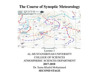
Meteo 003: Lab 6 Chapter 8: 1abc, 2abcd, 7ab, 9a, 11ab Chapter 9: 2, 6ab
8.1ab pg. 345 a) Lapse rate defined as rate of temperature decrease with altitude ??????? ???? ?????????? ?? ????????;????? ?/?? *(+ when temp. decreases w/ altitude) ????? ???? = = b) Stable: < 6 C/km ( ?) Conditionally Unstable: 6 C/km < < 10 C/km Unstable: > 10 C/km ( ?) Be sure to reference lapse rates in your response
8.1 Example Calculate the lapse rates for the two layers and determine the stability of each layer Height Above Ground (m) Temperature (C) 0 20 500 21 1000 15.5
8.1c Only need to do lowest 3 layers Need to calculate temperature of parcel from dry and moist adiabatic ascent Use ?=10 C/km and ?=6 C/km Is parcel positively buoyant for both ascents? (unstable) negatively buoyant for both ascents? (stable) positive/negative for one of each? (conditionally unstable) Positively Buoyant: parcel is warmer than environment Negatively Buoyant: parcel is cooler than environment
8.2 pg. 345 a) Parcel will initially cool at dry adiabatic lapse rate What will the temperature need to be for a cloud to form? At what level does the parcel reach this temperature? b) Parcel cools at moist adiabatic lapse rate the rest of the way Find the temperature of the parcel at the peak (2500 m)
8.2 cntd c) Is the parcel warmer or cooler than the environment? If: Warmer -> Positively Buoyant -> Continue rising Colder -> Negatively Buoyant -> Sink back down d) Parcel is unsaturated now and descends 2500 m Warms at the dry adiabatic lapse rate (10 C/km) during descent What processes occurred during ascent/descent that could have affected the temp. of the parcel?
8.2 Example Assume a parcel starts at sea level and is forced to rise up Mt. Washington (~2000 m). The initial temperature and dew point of the parcel at sea level is 15 C and 10 C respectively. The environmental temperature at the summit is -4 C. Assume dew point remains constant during initial ascent. Remember that once the parcel is saturated both temperature and dewpoint will decrease together. Find the level you d expect a cloud to form, the temperature of the parcel at the peak of the mountain, and determine if the parcel will continue to rise (unstable) or sink back down (stable).
8.7ab pg. 349 a) Think of an air parcel descending from 9500 m to 1800 m Parcel will warm at dry adiabatic lapse rate Calculate the temperature change in that descent b) Is the temperature calculated from part (a) a comfortable room temperature? Convert Celsius to Fahrenheit to help
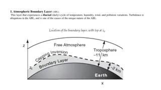
8.9a pg. 351 Parcels rise in unstable layers, whereas in stable layers they remain trapped close to the ground Is fog and haze more likely to form in unstable or stable layers? Reference figure 8.63a in your answer
8.11ab pg. 352 a) Clouds show up as white blobs on visible imagery Add in your response what the wind direction is. Look at cloud-free areas near the lakes to help figure it out. b) Winter/Summer? Morning/Afternoon/Evening/Overnight? Clouds shown are convective cumulus clouds What season and time of day are these most likely to form where they are? Think about the temperature of water and land at these times
9.2 pg. 401 First need to convert temperature to Kelvins ????? ?? ????? = 20 ? Units for speed here are m/s *this is an approximate equation, so units do not work out Example) -Estimate the elapsed time between seeing lightning and hearing thunder if the strike is 2 km away and the air temperature is 68 F
9.6ab pg. 405 a) Parcels will cool at dry adiabatic lapse rate initially Determine the temperature parcels need to cool to for it to reach saturation at each location b) High-based thunderstorms lead to evaporation of the rain before it reaches the ground, which leads to fires
Chapter 8: 1abc, 2abcd, 7ab, 9a, 11ab Chapter 9: 2, 6ab Astrid (ais5396@psu.edu): 10-11 AM in 511 Walker Josh (jig5374@psu.edu): 2-3 PM in 6th Floor Walker Wx Center Zach (zmg5025@psu.edu): 4-5 PM in 6th Floor Walker Wx Center