Coupled Terrestrial-Coastal Modeling of Carbon Exchange in the Gulf of Mexico

Explore the interactions between terrestrial and coastal systems in the Mississippi-Atchafalaya Basin and Northern Gulf of Mexico through coupled terrestrial-coastal ocean modeling. The study focuses on carbon dynamics, uncertainties in coastal carbon budgets, and the NASA IDS project's approach. Funding is from NASA and other organizations to support research on carbon management efforts.

Download Presentation

Please find below an Image/Link to download the presentation.
The content on the website is provided AS IS for your information and personal use only. It may not be sold, licensed, or shared on other websites without obtaining consent from the author. Download presentation by click this link. If you encounter any issues during the download, it is possible that the publisher has removed the file from their server.
E N D
Presentation Transcript
Observations and Coupled Terrestrial- Coastal Ocean Modeling of Carbon-Cycle Exchange in the Mississippi-Atchafalaya Basin and Northern Gulf of Mexico Steven Lohrenz (U. Mass Dartmouth) Wei-Jun Cai (U. Georgia) Hanqin Tian (Auburn) Ruoying He (N. Carolina State U.) Zuo Xue (N. Carolina State U.) Katja Fennel (Dalhousie) Charles Hopkinson (U. Georgia) Stephan Howden (U. Southern Miss.)
Acknowledgements Project is funded through the NASA Interdisciplinary Research in Earth Sciences and the NASA Carbon Monitoring System programs Additional funding, data and cruise support provided by NSF, NOAA, EPA, and USGS
Overview Introduction Coupled models for the study of carbon dynamics in complex systems Uncertainties in coastal carbon budgets Current projects: NASA IDS: Coupled Terrestrial-Ocean Models - A Case Study in the Gulf of Mexico Carbon Monitoring System Projects: Phase 1 and Phase 2 Approach Descriptions of the models Dynamic Land Ecosystem Model Coastal Ocean Biogeochemical Model Model integration Results to Date Data development Model refinement and validation Integration of terrestrial and ocean models Next Steps
Introduction: Coupled modeling approaches to examine carbon dynamics in complex systems Current research in carbon cycle science often focuses on specific subsystems (e.g., ocean, forest, tundra, urban, etc.) However, interactions among subsystems can lead to nonlinear relationships in their response to changes in external forcing Such interactions complicate efforts to predict how systems will behave and may produce unintended consequences for carbon management efforts
Introduction: Uncertainties in Coastal Carbon Budgets Carbon fluxes in the coastal margins remain poorly constrained in global carbon budgets Large uncertainties remain particularly in the temporal and spatial patterns of variability Reductions in uncertainties as well as ability to project changes in carbon fluxes in response to climate- and human-related activities will benefit carbon management efforts P. Coble Najjar presentation and numerous posters by Cai, Herrmann, Friedrichs, Alin, Signorini, Wang, Vlahos, and others
NASA IDS Project - Coupled Terrestrial-Ocean Models: A Case Study in the Gulf of Mexico Changing climate and land use practices can dramatically alter hydrologic and biogeochemical processes in terrestrial environments Such changes influence the delivery of water, carbon and nutrients into rivers, estuaries, and coastal ocean waters Here, we use the Mississippi River watershed and northern Gulf of Mexico as a case study to illustrate linkages between terrestrial and ocean ecosystems
NASA Carbon Monitoring System Projects Phase 1: Estimation of land ocean atmosphere carbon fluxes and exchanges in the Mississippi River Land-ocean C and nutrient fluxes Coastal margin air-sea C exchange Coastal to open ocean C exchange Phase 2: Development of observational tools and coupled models of land-ocean-atmospheric fluxes and exchanges in the Mississippi River watershed and Gulf of Mexico in support of carbon monitoring Advances the Phase 1 effort by using coupled terrestrial and ocean models Develop geo-referenced products Estimate uncertainties
Approach: Coupled Terrestrial-Ocean Models DLEM terrestrial outputs linked to a physical- biogeochemical model to characterize coastal carbon fluxes and ecosystem dynamics Dynamic Land Ecosystem Model used to estimate spatial and temporal patterns of delivery of water, carbon, and nitrogen and compared to data- based observations Modeling efforts will be supported by field survey-based and satellite-based observations of carbon fluxes and other biogeochemical processes Tian et al., 2010a,b; Tian et al.,2011, Tian et al.,2012 Hyun and He (2010); Xue et al. in prep Hoffman et al., Ann. Rev., 2011; Fennel et al., 2011 and in prep.
Approach: Dynamic Land Ecosystem Model Tian et al., 2010a,b; Tian et al.,2011, Tian et al.,2012, Tao et al. 2013 See Tian et al., poster 241, Tuesday Dynamic Land-Ecosystem Model (DLEM2.0)
Conceptual Model of DLEM See Tian et al., poster 241, Tuesday Coupling of biogeochemical and hydrological cycles (C,N,P,H2O) in DLEM
NASA IDS Terrestrial Domain: Mississippi- Atchafalaya Basin The drainage basin for the Mississippi- Atchafalaya river system covers 41% of the conterminous U.S. Among the ten largest rivers in the world with respect to water and sediment discharge and the largest in the North American continent Temperate or sub-polar needleleaf forest Tropical or sub-tropical broadleaf evergreen Temperate or sub-polar broadleaf deciduous Mixed Forest Temperate or sub-polar shrubland Temperate or sub-polar grassland Sub-polar or polar grassland-lichen-moss Wetland Cropland Barren Lands Urban and Built-up Water Tian et al.
Approach: SABGOM Hoffman et al., Ann. Rev., 2011; Fennel et al., 2011 and in prep. See He et al., poster 242, Tuesday
Results to Date Assemble terrestrial data sets for model input 1900 1950 Land cover Historical and projected climate Land use Disturbance and regrowth Manure/fertilizer Population data 75% 0 75% 0 2005 1250 Crop_area 1200 1150 Crop area (1000 km2) 1100 1050 1000 950 900 75% 0 850 800 1901 1911 1921 1931 1941 1951 1961 1971 1981 1991 2001 Spatial and temporal patterns of cropland in the Mississippi- Atchafalaya River Basin during 1901-2008 (Tian et al.)
Results to Date Model refinement and validation 1400 DLEM-simulated (MARB) DIC River Discharge 32 Raymon and Cole,2003 (MRB) 1200 River discharge (km3/year) 27 DIC export (Tg C/yr) 1000 22 800 17 600 12 400 DLEM-estimated USGS Observation 7 200 2 0 1954 1959 1964 1969 1974 1979 1984 1989 1994 1999 2004 2009 1965 1970 1975 1980 1985 1990 1995 2000 2005 2010 See Tian et al., poster 241, Tuesday Comparison of simulated (blue line) and observed (red dots) total inorganic carbon in the vicinity of the Mississippi River outflow region Xue et al. in prep
Relative contributions from LUCC and climate DLEM-simulated total N export (DIN+DON+PON) driven by land use/cover change (LUCC, including land management), climate change and all the environmental changes Tian et al.
Results to Date Higher DIN in recent decade due to population growth and land use practices DLEM simulated (a) Dissolved Inorganic Nitrogen (DIN, NO3+NH4) and (b) Dissolved Inorganic Carbon (DIC) input from the Mississippi- Atchafalaya River Basin system in the first decade of the 20th and 21st centuries See He et al., poster 242, Tuesday
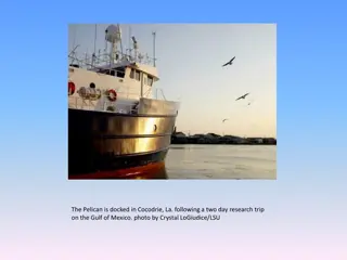
Results to Date Data set development: extensive ship-based observations in the northern Gulf of Mexico region from 2003 - 2012 Huang et al., 2012, Biogeosci. and in review Guo et al., 2012, Limnol. Oceanogr. Cai et al., 2011, Nature Geosci. Cai et al., 2011, Ann. Rev. Mar. Sci. Two Ph.D. dissertations, other papers in prep. Jun 24-31 2003 R/V Pelican Aug 1-8 2004 R/V Pelican Oct 3-7 2005 R/V Pelican Apr 27 - May 1 2006 R/V Pelican Jun 6-11 2006 OSV Bold (EPA) Sep 6-11 2006 OSV Bold (EPA) Jul 10 - Aug 4 2007 R/V Brown (NOAA) May 1-8 2008 R/V Pelican 31 Oct-7 Nov 2008 R/V Pelican Jan 8-20 2009 R/V Cape Hatteras Apr 19 - May 1 2009 R/V Cape Hatteras July 18 - 30 2009 R/V Cape Hatteras Oct 28 - Nov 9 2009 R/V Sharp Mar 11-21 2010 R/V Cape Hatteras Jul 21 Aug 13 2012 R/V Ronald H. Brown www.gulfcarbon.org
Results to Date Model refinement and validation Positions (red dots) of in situ observations and three sub-regions (near field, intermediate, and far field) where area- mean time series comparisons were made. Also shown is 50 m isobath See He et al., poster 242, Tuesday
Model refinement and validation Time series comparisons between observed (red) and simulated (blue) NO3 and chlorophyll in three sub-regions of the northern Gulf See He et al., poster 242, Tuesday
Model refinement and validation Comparison between simulated (left) and observed (right) seasonal mean surface Chl-a concentration See He et al., poster 242, Tuesday
Next Steps Temperature and precipitation under high (A2) and low (B1) emissions scenarios These data will provide inputs to the land ecosystem model Outputs include freshwater discharge and export of carbon and nitrogen, which feed into coastal model 18 A2_temperature 16 B1_temperature Temperature(oC/yr) Historical_temperature 14 12 10 8 1900 1920 1940 1960 1980 2000 2020 2040 2060 2080 2100 A2_precipitation 1050 B1_precipitation Precipitation (mm/yr) Historical _preciptation 850 650 450 1900 1920 1940 1960 1980 2000 2020 2040 2060 2080 2100
Next Steps Develop both hindcasts (1900-1910, 2000-2010) and forecasts (2090-2100) Examine sensitivity to different drivers: Climate (temperature, precipitation, solar radiation, relative humidity) Land cover change Land management including nitrogen fertilizer use, irrigation Atmospheric CO2 concentration Atmospheric nitrogen deposition Tropospheric ozone pollution For forecasts, use two IPCC climate scenarios (A2, B1) including different land use scenarios, freshwater, and nutrient loading climate projections
Land Carbon Management Land Use Practices Water and Forest Management Agriculture, Fertilizer GHGs Energy and Biofuels Development Future Applications Model development will provide decision support for issues related to carbon management, water quality, and ecosystem sustainability Coastal Margin Air-sea flux of CO2 Nutrients and Hypoxia Ocean Acidification Wetlands Loss Coastal Restoration Water Quality Fisheries Habitat Sea Level Rise Ocean Carbon Reservoir Long term Sequestration of Carbon?
Thank you! www.gulfcarbon.org