Coastal Climate Change Impacts and Adaptation Strategies Overview

This overview delves into the impacts of climate change on coastal areas, including shoreline changes, coastal hazards, and coastal geomorphic systems. It highlights the physical forcing mechanisms, such as sea level rise and increased storm activity, affecting these regions. The assessment emphasizes the importance of engaging stakeholders and promoting a consistent framework for mitigation and adaptation strategies. It also focuses on coastal ecosystems as key tools for enhancing community resilience and provides recommendations for effective management practices.

Download Presentation

Please find below an Image/Link to download the presentation.
The content on the website is provided AS IS for your information and personal use only. It may not be sold, licensed, or shared on other websites without obtaining consent from the author. Download presentation by click this link. If you encounter any issues during the download, it is possible that the publisher has removed the file from their server.
E N D
Presentation Transcript
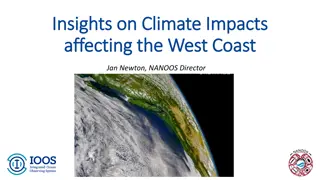
Overview Climate Change Impacts State and Federal partnership
1. Impacts from Climate Change Shoreline changes Coastal areas Communities Coastal hazards 18 ft. tide 18.5 ft. tide
Scope of Work A west coast-wide assessment Recommendations to mitigate and adapt Engage with stakeholders Promote a consistent frame of reference Liaison with the Sediment Management ACT Align methods and tools to improve info exchanges
Shoreline Changes Sea level rise and storminess estimates Develop a consensus of estimates and uncertainties For 2030, 2050, and 2100 Bring together west coast scientists Assess climate/weather models of extreme events
Coastal Areas and Hazards Natural Shorelines ID the physical forcing mechanisms Develop a common classification system ID and catalogue potential impacts ID possible assessment methods and predictive models Modified Shorelines Develop a common classification system Identify and catalogue impacts
Coastal Geomorphic Systems Rocky Coasts and Headlands e.g., plunging sea cliffs Deposition Coasts e.g., barrier beaches, spits, beaches, dunes Erosion Coasts e.g., bluffs, marine terraces, sea cliffs Estuaries and Lagoons e.g., barrier estuaries, closed lagoons and marshes
Physical Forcing Mechanisms Sea Level Rise Increased Storm Activity Increased Wave Height Changes in: Seasonal stream flows Seasonal precipitation patterns Long-term precipitation patterns Dominant wind pattern Sediment composition and budget
Communities Coastal ecosystems as adaptation tools for community and resource managers planning ID habitat types for protection, restoration and/or enhancement Highlight priorities and Best Management Practices for managers Use coast-wide habitat map to identify hotspots of threatened habitats Provide guidance for adding resilience to buffering habitats
2. State and Federal interests Progress and coordination Challenges Uses of data in decision-making State and Federal partnership
Progress and Coordination Progress NAS study on West Coast SLR and Storminess Estimates was funded Physical impacts assessment: natural shorelines Summary of potential ecosystem impacts - $20,000 to support intern Adaptation strategies database
Challenges Funding Continuing to look for additional funding sources Staffing , we now have NOAA Coastal Fellows in 3 states working on coastal climate impacts WCGA funding for an intern to characterize observed and anticipated ecosystem effects of SLR, storminess, and extreme events on coastal habitats (section 2.3 of work plan)
Uses of data in decision-making Coastal Climate Change Adaptation Guidebook To provide tools and resource to coastal resource managers Information Needs to plan for coast impacts/ inundation Identify key baseline data needed such as: shoreline maps and collection of topographic and bathymetric merged data (e.g., LIDAR); coastal vertical uplift and subsidence Work with the Seafloor Mapping ACT to identify potential sources for the bathymetric and topographic data and the resources needed to create accurate shoreline maps.
The Fed-State partnership Ecosystem Impact Assessment: Co-sponsored a conference for coastal natural resource managers, highlighting the state of the science presentations from ecological, climate, and policy experts. [Completed January 2009]. NAS study supported by 3 states, NOAA, USGS, and the Army Corps of Engineers Develop database of adaptation methods with the Climate Impacts Group (CIG) Co-chairs for Climate Change ACT