Educational Lesson on Bearings and Navigation for Students

Students will apply their knowledge of bearings to a real-world navigation scenario, including measuring and constructing bearings, and calculating distances using scale. The lesson is part of a series focused on Mysteries of the Deep Earth, specifically planning a research voyage to Australia's underwater volcanoes. Science objectives include studying hotspot dynamics, mapping underwater landscapes, and analyzing the relationship between geomorphology and biodiversity in the Coral Sea Australian Marine Park. Students will engage with actual research objectives and data from the voyage to enhance their learning experience.

Download Presentation

Please find below an Image/Link to download the presentation.
The content on the website is provided AS IS for your information and personal use only. It may not be sold, licensed, or shared on other websites without obtaining consent from the author. Download presentation by click this link. If you encounter any issues during the download, it is possible that the publisher has removed the file from their server.
E N D
Presentation Transcript
Introduction for educators Before undertaking this lesson, students should be confident with the use of protractors to measure angles. The objective of this lesson is for students to apply their knowledge of bearings to a real-world navigation scenario. Students will be required to measure bearings and, if they reach the extension activity, construct bearings. In addition to using bearings, students are also required to use their knowledge of scale to calculate the distances travelled on each bearing. Introductions to the objectives of the research voyage associated with this series of lessons can be seen on slides 3 and 4. These slides describe the same objectives but targeted at different levels of reader. Answers for the activities can be found on the slides towards the end of this presentation. These lessons have all been tested in a UK secondary school setting. However, any feedback or reviews are warmly received.
Australias R/V Investigator, the ship being used for the research. Image credit: CSIRO Title: Bearings and Navigation Planning the voyage This lesson is one of a series focused on Mysteries of the Deep Earth: Expedition to Australia's Underwater Volcanoes
What are we investigating? The science objectives of this voyage are: Hotspot dynamics in the Coral Sea: connections between the Australian Plate and the deep Earth. Scientists will be collecting rocks from volcanoes along a submerged seamount chain and using sound, magnetics and gravity to make 3D maps of the volcano shapes. These chains are similar to the Hawaiian and Canary Islands in that they are volcanoes which formed away from the edges of tectonic plates (such as in the Pacific Ring of Fire , and scientists want to understand how, why and when they formed. Understanding the spatial links between geomorphology and biodiversity in the Coral Sea Australian Marine Park. Maps of the underwater volcanoes will be analysed to understand how different shapes, structures and underwater landscapes provide habitats for marine species such as corals and invertebrates. Spatial and temporal variability in the distribution and abundance of seabirds. Scientists on the observation deck high on the ship will be observing seabirds and marine mammals (such as whales and dolphins) to understand where they live and their behaviours.
What are we investigating? The science objectives of this voyage are: Mapping the underwater landscapes. Scientists will use special mapping techniques to make 3D maps of underwater volcanoes that have been discovered in the Coral and Tasman Seas. Using rocks that they collect from these sites, scientists want to understand how, why and when these underwater volcanoes formed. Why do marine species like living on underwater volcanoes? Maps of the underwater volcanoes will be analysed to understand how different shapes, structures and underwater landscapes provide habitats for marine species such as corals and invertebrates. Are there more seabirds and marine mammals near these underwater volcanoes than in the surrounding waters? Scientists on the observation deck high on the ship will be observing seabirds and marine mammals (such as whales and dolphins) to understand where they live and their behaviours.
Where are we going? UK Coral Sea, Australia
For this lesson you will need: Ruler Pencil Protractor Calculator
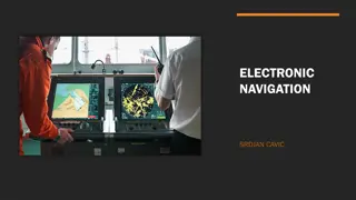
How do you navigate at sea if there are no roads? Australia s R/V Investigator, the ship being used for the research. Image credit: CSIRO Bearings!
Three rules for bearings They must start from NORTH They must be measured CLOCKWISE They must have THREE DIGITS
Compass Points 360 000 N 045 315 NW NE E 270 W 090 SW SE 225 135 S 180
Example 1: What is the rough compass direction from Cairns to Brisbane? What is the bearing from Cairns to Brisbane? South East 148 North Cairns Brisbane
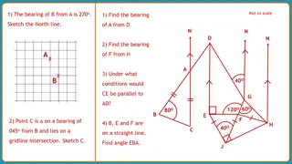
Measuring Bearings Find the bearing of A from B. Mark the North line on at B (if there isn t a North line draw one in) N A Measure the angle clockwise from the North line to A 75 Give the answer as a three- figure bearing B 075
Measuring Bearings Find the bearing of A from B. Mark the North line on at B (if there isn t a North line draw one in) N A Measure the angle clockwise from the North line to A B 294 Give the answer as a three- figure bearing 294
Example 2: The scale bar shows you the distance of 300km on your map. How many centimetres long is the 300km bar on your map? What distance does 1cm represent on your map? . How many centimetres is it on your map from Cairns to Brisbane? . What is the distance from Cairns to Brisbane? 2cm 300 2 = 150km ~9.3cm 9.3 x 150 = 1395km Cairns North Brisbane 300km 2cm
Your Task: Work in pairs, with one of you finding the bearing and one of you finding the distance. Swap over after Site 7. You are the navigator on the voyage. The scientists have told you a number of key sites where they want to collect data and have marked them on the map. Calculate the bearings and distances that you will have travel on at each point in voyage so you can tell the captain where to sail. The voyage will set sail from Cairns and finish in Brisbane. Make sure that you measure the angles and distances accurately; you don t want to end up shipwrecked!
Your Task: Work in pairs, with one of you finding the bearing and one of you finding the distance. Swap over after Site 7. Calculate the bearings and distances that you will have travel on at each point in voyage so you can tell the captain where to sail. The voyage will set sail from Cairns and finish in Brisbane. Step 1. Measure the bearing. Cairns to Site 1. = 118o Make sure that you measure the angles and distances accurately; you don t want to end up shipwrecked!
Your Task: Work in pairs, with one of you finding the bearing and one of you finding the distance. Swap over after Site 7. Calculate the bearings and distances that you will have travel on at each point in voyage so you can tell the captain where to sail. The voyage will set sail from Cairns and finish in Brisbane. 300km = 2cm on your maps Step 2. Measure and calculate the distance. Cairns to Site 1. 7.5cm 7.5 x 150 = 1125km 300km = 2cm ___km = 1cm Make sure that you measure the angles and distances accurately; you don t want to end up lost at sea!
Your Task: Work in pairs, with one of you finding the bearing and one of you finding the distance. Swap over after Site 7. Calculate the bearings and distances that you will have travel on at each point in voyage so you can tell the captain where to sail. The voyage will set sail from Cairns and finish in Brisbane. 300km = 2cm on your maps Cairns to Site 1: Bearing: 118o Distance: 1125km Cairns to Site 1. 7.5cm 7.5 x 150 = 1125km Make sure that you measure the angles and distances accurately; you don t want to end up lost at sea!
Answers Bearing (o) Start End Distance cm km 7.5 1125 Cairns Site 1 120 1 150 Site 1 Site 2 30 300km = 2cm on your maps 1 150 Site 2 Site 3 288 2 300 Site 3 Site 4 39 1.7 255 Site 4 Site 5 345 1.1 165 Site 5 Site 6 78 2.6 390 Site 6 Site 7 301 2.5 375 Site 7 Site 8 56 1.3 195 Site 8 Site 9 69 3.5 525 Site 9 Site 10 193 2 300 Site 10 Site 11 110 2.6 390 Site 11 Site 12 204 Make sure that you measure the angles and distances accurately; you don t want to end up lost at sea! 2.3 345 Site 12 Site 13 166 1.8 270 Site 13 Site 14 180 5.3 795 Site 14 Site 15 236
Extension Our eagle eyed wildlife spotters have seen some great wildlife whilst on board the ship. 300km = 2cm on your maps Can you plot these sightings on your maps? Hammerhead Shark: Bearing 090, 450km from Cairns Humpback Whale Bearing 260, 150km from Site 7. Tuna Bait Ball Bearing 135, 300km from Site 14. Make sure that you measure the angles and distances accurately; you don t want to end up lost at sea!
Extension Can you calculate the total distance the ship will travel if it follows the proposed track? 300km = 2cm on your maps If the ship travels at an average speed of 11knots 20km/h for the duration of the voyage, how long will the voyage take? Make sure that you measure the angles and distances accurately; you don t want to end up lost at sea!
Review Quiz What are the three key rules for bearings? They must start from NORTH They must be measured CLOCKWISE They must have 3 DIGITS Where did the voyage start? Where did the voyage finish? Cairns Brisbane Can you name one of the animals spotted en route? Humpback Whale, Hammerhead Shark, Tuna Bait Ball