Motorboat Training, testing, and licensing: Rules of the Road & Aids to Navigation Manual

 undefined


M
O
T
O
R
B
O
A
T
T
R
A
I
N
I
N
G
,
T
E
S
T
I
N
G
A
N
D
L
I
C
E
N
S
I
N
G
Presenter:
Title:
Rules of the Road &
Aids to Navigation (ATONS)
Manual – TAB 4
Date:
2
Objectives:
Navigation Rules
“The Rules of the Road”
•
Learn the purpose of “Rules”
•
Learn Navigational terms
•
Learn to interpret navigation lights
•
Learn the basic Inland Navigation
Rules for crossing, meeting &
overtaking situations.
•
Learn the “Pecking Order” for vessels
3
Who wrote the rules?
“Navigation Rules”
Are published by the
U.S. Department of
Homeland Security for
the United States Coast
Guard
Updated copies can be
downloaded online at:
www.navcen.uscg.gov
4
What do the Rules do?
If followed, they
protect against
loss of life, injury,
and property
damage as a
result of collision.
Prevent Accidents
5
Where do the Rules apply?
O
n
U
S
I
n
l
a
n
d
o
r
I
n
t
e
r
n
a
t
i
o
n
a
l
W
a
t
e
r
s
.
(
R
u
l
e
1
)
6
M
o
s
t
C
o
l
l
i
s
i
o
n
s
C
o
u
l
d
B
e
A
v
o
i
d
e
d
B
y
…
•
P
r
a
c
t
i
c
i
n
g
t
h
e
“
R
u
l
e
s
o
f
t
h
e
R
o
a
d
”
–
R
u
l
e
1
•
U
s
e
o
f
a
“
p
r
o
p
e
r
l
o
o
k
o
u
t
”
–
R
u
l
e
5
•
M
a
i
n
t
a
i
n
i
n
g
s
a
f
e
s
p
e
e
d
–
R
u
l
e
6
•
D
i
s
p
l
a
y
i
n
g
p
r
o
p
e
r
l
i
g
h
t
s
-
R
u
l
e
2
0
•
Knowing the “Aids to Navigation”
7
Ground Rules for
Navigation
Responsibility & Definitions
8
General Definitions
U
n
d
e
r
w
a
y
-
n
o
t
a
t
a
n
c
h
o
r
o
r
m
a
d
e
f
a
s
t
t
o
t
h
e
s
h
o
r
e
o
r
a
g
r
o
u
n
d
R
i
g
h
t
-
o
f
-
w
a
y
–
t
h
e
r
i
g
h
t
a
n
d
d
u
t
y
t
o
m
a
i
n
t
a
i
n
c
o
u
r
s
e
a
n
d
s
p
e
e
d
S
t
a
n
d
-
O
n
V
e
s
s
e
l
–
v
e
s
s
e
l
t
h
a
t
h
a
s
t
h
e
r
i
g
h
t
o
f
w
a
y
G
i
v
e
W
a
y
V
e
s
s
e
l
–
m
u
s
t
k
e
e
p
c
l
e
a
r
o
f
t
h
e
s
t
a
n
d
-
o
n
v
e
s
s
e
l
S
h
o
r
t
B
l
a
s
t
-
a
b
l
a
s
t
o
f
a
p
p
r
o
x
i
m
a
t
e
l
y
1
s
e
c
o
n
d
P
r
o
l
o
n
g
e
d
B
l
a
s
t
–
a
b
l
a
s
t
o
f
4
t
o
6
s
e
c
o
n
d
s
9
S
a
f
e
S
p
e
e
d
-
S
p
e
e
d
t
h
a
t
a
l
l
o
w
s
p
r
o
p
e
r
a
n
d
e
f
f
e
c
t
i
v
e
a
c
t
i
o
n
t
o
a
v
o
i
d
c
o
l
l
i
s
i
o
n
b
a
s
e
d
o
n
t
h
e
f
o
l
l
o
w
i
n
g
f
a
c
t
o
r
s
.
•
Visibility
•
Traffic density and characteristics.
•
Maneuverability, draft.
•
Background clutter.
•
Weather, wind, current, navigational
hazards
General Definitions cont’d
10
ENCOUNTERING OTHER
VESSELS
R
U
L
E
1
3
O
V
E
R
T
A
K
I
N
G
-
V
e
s
s
e
l
t
h
a
t
i
s
p
a
s
s
e
d
b
y
a
n
o
t
h
e
r
f
r
o
m
a
p
o
s
i
t
i
o
n
m
o
r
e
t
h
a
n
2
2
.
5
d
e
g
r
e
e
s
a
b
a
f
t
o
f
i
t
’
s
b
e
a
m
i
s
t
h
e
s
t
a
n
d
-
o
n
v
e
s
s
e
l
.
T
h
e
g
i
v
e
-
w
a
y
v
e
s
s
e
l
s
h
o
u
l
d
n
o
t
s
e
e
t
h
e
g
r
e
e
n
o
r
r
e
d
n
a
v
i
g
a
t
i
o
n
s
i
d
e
l
i
g
h
t
s
.
I
f
i
n
d
o
u
b
t
w
h
e
t
h
e
r
o
v
e
r
t
a
k
i
n
g
o
r
c
r
o
s
s
i
n
g
,
a
l
w
a
y
s
a
s
s
u
m
e
o
v
e
r
t
a
k
i
n
g
.
Give-way vessel will keep clear of
stand-on vessel until finally well
past and clear.
B
u
t
b
e
c
a
r
e
f
u
l
!
W
h
i
t
e
l
i
g
h
t
o
n
l
y
c
o
u
l
d
a
l
s
o
i
n
d
i
c
a
t
e
a
v
e
s
s
e
l
s
a
i
l
i
n
g
o
r
a
v
e
s
s
e
l
a
t
a
n
c
h
o
r
o
r
u
n
d
e
r
o
a
r
s
.
11
R
U
L
E
1
4
H
E
A
D
O
N
-
W
h
e
n
t
w
o
p
o
w
e
r
-
d
r
i
v
e
n
v
e
s
s
e
l
s
a
r
e
o
n
r
e
c
i
p
r
o
c
a
l
c
o
u
r
s
e
s
,
v
e
s
s
e
l
s
w
i
l
l
s
t
e
e
r
t
o
s
s
t
t
a
a
r
r
b
b
o
o
a
a
r
r
d
d
s
o
e
a
c
h
s
h
a
l
l
p
a
s
s
p
p
o
o
r
r
t
t
t
t
o
o
p
p
o
o
r
r
t
t
o
f
e
a
c
h
o
t
h
e
r
.
A
t
n
i
g
h
t
,
v
e
s
s
e
l
s
i
n
a
h
e
a
d
-
o
n
s
i
t
u
a
t
i
o
n
s
h
o
u
l
d
o
b
s
e
r
v
e
m
a
s
t
h
e
a
d
l
i
g
h
t
(
s
)
i
n
a
l
i
n
e
a
n
d
o
n
e
o
r
b
o
t
h
s
i
d
e
l
i
g
h
t
s
.
12
R
U
L
E
1
5
C
R
O
S
S
I
N
G
-
A
v
e
s
s
e
l
w
h
i
c
h
h
a
s
a
n
o
t
h
e
r
v
e
s
s
e
l
o
n
h
e
r
s
s
t
t
a
a
r
r
b
b
o
o
a
a
r
r
d
d
s
i
d
e
s
h
a
l
l
k
e
e
p
o
u
t
o
f
t
h
e
w
a
y
o
f
t
h
e
o
t
h
e
r
a
n
d
i
f
n
e
c
e
s
s
a
r
y
,
a
v
o
i
d
c
r
o
s
s
i
n
g
a
h
e
a
d
o
f
t
h
e
o
t
h
e
r
v
e
s
s
e
l
.
O
n
t
h
e
G
r
e
a
t
L
a
k
e
s
a
n
d
W
e
s
t
e
r
n
R
i
v
e
r
s
,
a
v
e
s
s
e
l
c
r
o
s
s
i
n
g
a
r
i
v
e
r
s
h
a
l
l
k
e
e
p
o
u
t
o
f
t
h
e
w
a
y
o
f
a
n
a
s
c
e
n
d
i
n
g
o
r
d
e
s
c
e
n
d
i
n
g
v
e
s
s
e
l
.
13
Rule 18 Responsibilities Between Vessels (Inland)
R.O.W. Pecking Order
Privileged
Not under command (NUC)
Restricted in ability to maneuver (RAM)
(dredging, mine sweeping)
Fishing/trawling (not trolling)
Sail or manually powered boat
Power-driven
Seaplane
Burdened
14
Navigation Lights and Shapes
(Rules 20 - 31)
•
White 360 degree light required when anchored
•
Red
and
Green
lights (112.5 degree arc)
required when underway between sunset and
sunrise or in restricted visibility
S
S
t
t
e
e
r
r
n
n
l
l
i
i
g
g
h
h
t
t
1
1
3
3
5
5
Sidelight
Port
112.5
Sidelight
starboard
112.5
M
M
a
a
s
s
t
t
h
h
e
e
a
a
d
d
2
2
2
2
5
5
22.5
22.5
A
R
C
S
O
F
V
I
S
I
B
I
L
I
T
Y
R
U
L
E
S
2
0
t
h
r
u
3
1
L
I
G
H
T
S
A
N
D
S
H
A
P
E
S
Abaft of
Beam
Abaft of
Beam
16
•
N
a
v
i
g
a
t
i
o
n
l
i
g
h
t
s
s
h
o
u
l
d
b
e
c
h
e
c
k
e
d
p
r
i
o
r
t
o
d
e
p
a
r
t
i
n
g
t
h
e
d
o
c
k
•
L
i
g
h
t
s
s
h
o
u
l
d
b
e
u
s
e
d
b
e
t
w
e
e
n
s
u
n
s
e
t
a
n
d
s
u
n
r
i
s
e
a
n
d
d
u
r
i
n
g
r
e
s
t
r
i
c
t
e
d
v
i
s
i
b
i
l
i
t
y
•
A
l
w
a
y
s
c
a
r
r
y
s
p
a
r
e
b
u
l
b
s
Navigation
Lights
17
C
o
n
f
i
g
u
r
a
t
i
o
n
s
C
l
a
s
s
A
-
I
U
n
d
e
r
P
o
w
e
r
18
What are we seeing from these four light configurations?
19
RULES 34 MANUEVERING AND WARNING
I
n
l
a
n
d
Signals of intent with appropriate reply required
O
n
e
s
h
o
r
t
-
I
i
n
t
e
n
d
t
o
p
a
s
s
y
o
u
o
n
m
y
p
o
r
t
s
i
d
e
T
w
o
s
h
o
r
t
-
I
i
n
t
e
n
d
t
o
p
a
s
s
y
o
u
o
n
m
y
s
t
a
r
b
o
a
r
d
s
i
d
e
T
h
r
e
e
s
h
o
r
t
-
I
a
m
o
p
e
r
a
t
i
n
g
a
s
t
e
r
n
(
r
e
v
e
r
s
e
)
p
r
o
p
u
l
s
i
o
n
F
i
v
e
s
h
o
r
t
–
D
a
n
g
e
r
,
I
d
o
n
o
t
u
n
d
e
r
s
t
a
n
d
,
I
d
i
s
a
g
r
e
e
I
n
l
a
n
d
R
u
l
e
s
r
e
q
u
i
r
e
t
h
e
o
t
h
e
r
v
e
s
s
e
l
t
o
a
n
s
w
e
r
w
i
t
h
t
h
e
s
a
m
e
s
i
g
n
a
l
i
f
i
n
a
g
r
e
e
m
e
n
t
20
R
e
v
i
e
w
What is the purpose of the Navigation Rules?
What is the definition of “underway”?
What does one short blast indicate?
What does two short blasts indicate?
What does three short blasts indicate?
What does five short blasts indicate?
T or F? The overtaken vessel is the give-way vessel
What’s the arc of visibility for sidelights?
What’s the arc of visibility for a stern light?
What is the pecking order in the vessel “hierarchy”?
21
Q
U
E
S
T
I
O
N
S
?
AIDS TO NAVIGATION
(ATON)
Objectives:
•
Identify the Navigation Systems
•
IALA (International Association of Lighthouse
Authorities)
•
U.S. Aids to Navigation
•
Intracoastal Waterway
•
Western Rivers
•
Uniform State Waterway Marking System
•
Identify the Types of ATONs
•
Learn the application of Regulatory Buoys
23
To safely transit from one place to another
we use AIDS TO NAVIGATION (ATONS)…
24
Two Types of Aids to Navigation:
B
u
o
y
s
a
n
d
B
e
a
c
o
n
s
;
B
o
t
h
h
a
v
e
v
a
r
i
o
u
s
s
h
a
p
e
s
,
s
o
u
n
d
s
a
n
d
l
i
g
h
t
c
h
a
r
a
c
t
e
r
i
s
t
i
c
s
.
Buoys
Nun
Can
Bell
Whistle
Gong
Spar
Lighted buoys
25
Beacons
26
I
n
t
e
r
n
a
t
i
o
n
a
l
A
s
s
o
c
i
a
t
i
o
n
o
f
L
i
g
h
t
h
o
u
s
e
A
u
t
h
o
r
i
t
i
e
s
(
I
A
L
A
)
Navigation Systems
T
h
e
w
o
r
l
d
i
s
d
i
v
i
d
e
d
i
n
t
o
R
e
g
i
o
n
A
o
r
B
27
G
r
e
e
n
o
r
r
e
d
l
a
t
e
r
a
l
a
i
d
s
s
h
o
w
c
h
a
n
n
e
l
e
d
g
e
s
•
IALA System A and IALA System B regulate navigational
markings throughout most of the world.
•
System A is generally used in the Eastern Hemisphere
•
System B is generally used in the Western Hemisphere.
•
In Region A, green aids are on the right when returning
from sea.
•
In Region B, red aids are on the right. RED-RIGHT-
RETURNING
28
I
n
t
r
a
c
o
a
s
t
a
l
W
a
t
e
r
w
a
y
•
The Intracoastal Waterway (ICW) runs parallel to the Atlantic
and Gulf Coasts. Unofficially, it begins at Manasquan River,
NJ, which leads to Mile Zero at Norfolk, VA, then on to
Brownsville, TX and the Mexican Border. Most aids to
navigation on the ICW are conventional day beacons and
buoys, but the real identifier is the yellow triangle or square.
As you travel on the ICW from NJ to TX, triangles stay on your
right (towards the mainland) and squares stay on your left (to
sea).
•
Examples
29
Western Rivers
W
h
e
n
o
n
t
h
e
M
i
s
s
i
s
s
i
p
p
i
R
i
v
e
r
,
a
b
o
v
e
B
a
t
o
n
R
o
u
g
e
,
a
n
d
s
e
v
e
r
a
l
o
t
h
e
r
t
r
i
b
u
t
a
r
i
e
s
t
h
a
t
f
l
o
w
t
o
w
a
r
d
t
h
e
G
u
l
f
o
f
M
e
x
i
c
o
,
b
o
a
t
e
r
s
m
u
s
t
f
o
l
l
o
w
a
s
y
s
t
e
m
c
a
l
l
e
d
t
h
e
W
e
s
t
e
r
n
R
i
v
e
r
s
M
a
r
k
i
n
g
S
y
s
t
e
m
,
a
v
a
r
i
a
t
i
o
n
o
f
t
h
e
U
.
S
.
A
i
d
s
t
o
N
a
v
i
g
a
t
i
o
n
S
y
s
t
e
m
.
R
e
d
a
n
d
g
r
e
e
n
a
i
d
s
a
r
e
n
o
t
i
n
d
i
v
i
d
u
a
l
l
y
n
u
m
b
e
r
e
d
o
r
l
e
t
t
e
r
e
d
,
b
u
t
m
a
y
b
e
a
c
c
o
m
p
a
n
i
e
d
b
y
a
m
i
l
e
m
a
r
k
e
r
.
G
r
e
e
n
a
i
d
s
a
r
e
o
n
t
h
e
R
i
g
h
t
-
d
e
s
c
e
n
d
i
n
g
b
a
n
k
a
n
d
r
e
d
a
i
d
s
a
r
e
o
n
t
h
e
L
e
f
t
-
d
e
s
c
e
n
d
i
n
g
b
a
n
k
.
Crossing markers are used on river bends. Inbound
traffic takes the inside curve, Outbound takes the
outside.
R
E
D
r
i
g
h
t
R
e
t
u
r
n
i
n
g
a
p
p
l
i
e
s
30
U
S
A
i
d
s
t
o
N
a
v
i
g
a
t
i
o
n
(
U
S
A
T
O
N
S
)
•
U.S. Aids to Navigation (Navigable Waters Except
Western Rivers and Intracoastal Waterway).
Navigation aids in this lateral system are
determined by their position with respect to the
navigable channel, as the channels are entered
and followed from seaward toward the head of
navigation.
•
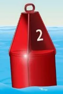
Green
aids are odd numbered
•
Red
aids are even numbered
•
R
E
D
r
i
g
h
t
R
e
t
u
r
n
i
n
g
a
p
p
l
i
e
s
31
Uniform State Waterway Marking System
•
This system was replaced by the USATONS system
in 2003.It was primarily used on lakes and other
inland waterways not portrayed on nautical charts.
32
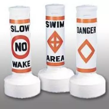
Regulatory
INFORMATION
CONTROLLED DANGER
EXCLUSION
33
Review:
•
Name the Navigation Systems
•
What are the two types of ATONS?
•
What mark(s) identify the Intracoastal
Waterway?
•
Nun buoys are what color and have ___
numbers?
•
Can buoys are what color and have ___
numbers?
•
Name the four types of Regulatory Buoys
34
Q
U
E
S
T
I
O
N
S
?
This presentation covers essential information on motorboat training, testing, and licensing, focusing on rules of the road and aids to navigation. It includes details on navigation rules, the importance of following them to prevent accidents, and where the rules apply. The content also explains who wrote the rules and provides general definitions related to navigation responsibility. The presentation emphasizes practicing safe navigation practices to avoid collisions and protect life, injury, and property damage.

Download Presentation

Please find below an Image/Link to download the presentation.
The content on the website is provided AS IS for your information and personal use only. It may not be sold, licensed, or shared on other websites without obtaining consent from the author. Download presentation by click this link. If you encounter any issues during the download, it is possible that the publisher has removed the file from their server.
E N D
Presentation Transcript
MOTORBOAT TRAINING, TESTING AND LICENSING Presenter: Title: Rules of the Road & Aids to Navigation (ATONS) Manual TAB 4 Date: The views, opinions and findings contained in this report are those of the authors(s) and should not be construed as an official Department of the Army position, policy or decision, unless so designated by other official documentation.
2 Navigation Rules The Rules of the Road 2 Objectives: Learn the purpose of Rules Learn Navigational terms Learn to interpret navigation lights Learn the basic Inland Navigation Rules for crossing, meeting & overtaking situations. Learn the Pecking Order for vessels
3 3 Who wrote the rules? Navigation Rules Are published by the U.S. Department of Homeland Security for the United States Coast Guard Updated copies can be downloaded online at: www.navcen.uscg.gov
4 What do the Rules do? 4 If followed, they protect against loss of life, injury, and property damage as a result of collision. Prevent Accidents
5 5 Where do the Rules apply? On US Inland or International Waters. ( Rule 1)
6 6 Most Collisions Could Be Avoided By Practicing the Rules of the Road Rule 1 Use of a proper lookout Rule 5 Maintaining safe speed Rule 6 Displaying proper lights - Rule 20 Knowing the Aids to Navigation
7 7 Ground Rules for Navigation Responsibility & Definitions
8 General Definitions Underway - not at anchor or made fast to the shore or aground Right-of-way the right and duty to maintain course and speed 8 Stand-On Vessel vessel that has the right of way Give Way Vessel must keep clear of the stand-on vessel Short Blast - a blast of approximately 1 second Prolonged Blast a blast of 4 to 6 seconds
9 General Definitions cont d 9 Safe Speed - Speed that allows proper and effective action to avoid collision based on the following factors. Visibility Traffic density and characteristics. Maneuverability, draft. Background clutter. Weather, wind, current, navigational hazards
ENCOUNTERING OTHER VESSELS RULE 13 OVERTAKING - Vessel that is passed by another from a position more than 22.5 degrees abaft of it s beam is the stand-on vessel. The give-way vessel should not see the green or red navigation sidelights. If in doubt whether overtaking or crossing, always assume overtaking. Give-way vessel will keep clear of stand-on vessel until finally well past and clear. But be careful! White light only could also indicate a vessel sailing or a vessel at anchor or under oars. 10 10
11 11 RULE 14 HEAD ON - When two power-driven vessels are on reciprocal courses, vessels will steer to starboard so each shall pass port to port of each other. At night, vessels in a head-on situation should observe masthead light(s) in a line and one or both sidelights.
12 12 RULE 15 CROSSING - A vessel which has another vessel on her starboard side shall keep out of the way of the other and if necessary, avoid crossing ahead of the other vessel. On the Great Lakes and Western Rivers, a vessel crossing a river shall keep out of the way of an ascending or descending vessel.
13 13 Rule 18 Responsibilities Between Vessels (Inland) R.O.W. Pecking Order Privileged Not under command (NUC) Restricted in ability to maneuver (RAM) (dredging, mine sweeping) Fishing/trawling (not trolling) Sail or manually powered boat Power-driven Seaplane Burdened
14 14 Navigation Lights and Shapes (Rules 20 - 31) White 360 degree light required when anchored Red and Green lights (112.5 degree arc) required when underway between sunset and sunrise or in restricted visibility
RULES 20 thru 31 LIGHTS AND SHAPES Sidelight starboard 112.5 Sidelight Port 112.5 Masthead 225 22.5 22.5 Abaft of Beam Abaft of Beam Stern light 135 ARCS OF VISIBILITY
16 16 Navigation Lights Navigation lights should be checked prior to departing the dock Lights should be used between sunset and sunrise and during restricted visibility Always carry spare bulbs
17 Configurations Class A-I Under Power 17
18 18 What are we seeing from these four light configurations?
19 19 RULES 34 MANUEVERING AND WARNING Inland Signals of intent with appropriate reply required One short - I intend to pass you on my port side Two short - I intend to pass you on my starboard side Three short - I am operating astern (reverse) propulsion Five short Danger, I do not understand, I disagree Inland Rules require the other vessel to answer with the same signal if in agreement
20 Review 20 What is the purpose of the Navigation Rules? What is the definition of underway ? What does one short blast indicate? What does two short blasts indicate? What does three short blasts indicate? What does five short blasts indicate? T or F? The overtaken vessel is the give-way vessel What s the arc of visibility for sidelights? What s the arc of visibility for a stern light? What is the pecking order in the vessel hierarchy ?
21 21 QUESTIONS?
22 AIDS TO NAVIGATION (ATON) Objectives: Identify the Navigation Systems IALA (International Association of Lighthouse Authorities) U.S. Aids to Navigation Intracoastal Waterway Western Rivers Uniform State Waterway Marking System Identify the Types of ATONs Learn the application of Regulatory Buoys
23 23 To safely transit from one place to another we use AIDS TO NAVIGATION (ATONS)
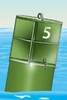
24 Two Types of Aids to Navigation: Buoys and Beacons; Both have various shapes, sounds and light characteristics. 24 Buoys Nun Can Bell Whistle Gong Spar Lighted buoys
25 25 Beacons
26 Navigation Systems 26 International Association of Lighthouse Authorities (IALA) The world is divided into Region A or B The world is divided into Region A or B
27 27 Green Green or red red lateral aids lateral aids show channel edges IALA System A and IALA System B regulate navigational markings throughout most of the world. System A is generally used in the Eastern Hemisphere System B is generally used in the Western Hemisphere. In Region A, green aids are on the right when returning from sea. In Region B, red aids are on the right. RED-RIGHT- RETURNING
28 28 Intracoastal Waterway The Intracoastal Waterway (ICW) runs parallel to the Atlantic and Gulf Coasts. Unofficially, it begins at Manasquan River, NJ, which leads to Mile Zero at Norfolk, VA, then on to Brownsville, TX and the Mexican Border. Most aids to navigation on the ICW are conventional day beacons and buoys, but the real identifier is the yellow triangle or square. As you travel on the ICW from NJ to TX, triangles stay on your right (towards the mainland) and squares stay on your left (to sea). Examples 13 14
29 Western Rivers 29 When on the Mississippi River, above Baton Rouge, and several other tributaries that flow toward the Gulf of Mexico, boaters must follow a system called the Western Rivers Marking System, a variation of the U.S. Aids to Navigation System. Red and green aids are not individually numbered or lettered, but may be accompanied by a mile marker. Green aids are on the Right-descending bank and red aids are on the Left-descending bank. Crossing markers are used on river bends. Inbound traffic takes the inside curve, Outbound takes the outside. RED right Returning applies
30 30 US Aids to Navigation (US ATONS) U.S. Aids to Navigation (Navigable Waters Except Western Rivers and Intracoastal Waterway). Navigation aids in this lateral system are determined by their position with respect to the navigable channel, as the channels are entered and followed from seaward toward the head of navigation. Green aids are odd numbered Red aids are even numbered RED right Returning applies
31 31 Uniform State Waterway Marking System This system was replaced by the USATONS system in 2003.It was primarily used on lakes and other inland waterways not portrayed on nautical charts.
32 32 Regulatory INFORMATION CONTROLLED DANGER EXCLUSION
33 33 Review: Name the Navigation Systems What are the two types of ATONS? What mark(s) identify the Intracoastal Waterway? Nun buoys are what color and have ___ numbers? Can buoys are what color and have ___ numbers? Name the four types of Regulatory Buoys
34 34 QUESTIONS?