Earth's Layers and Plate Tectonics Overview
Earth's layers, including the core, mantle, and crust, have different properties and compositions that shape the planet's structure. Scientists study seismic waves to understand Earth's interior. Plate tectonics play a crucial role in shaping the planet's surface features through the movement of lithospheric plates. This involves phenomena like subduction, seafloor spreading, and volcanic activity. Understanding these concepts helps in explaining natural events like earthquakes and mountain formation.

Download Presentation

Please find below an Image/Link to download the presentation.
The content on the website is provided AS IS for your information and personal use only. It may not be sold, licensed, or shared on other websites without obtaining consent from the author. Download presentation by click this link. If you encounter any issues during the download, it is possible that the publisher has removed the file from their server.
E N D
Presentation Transcript
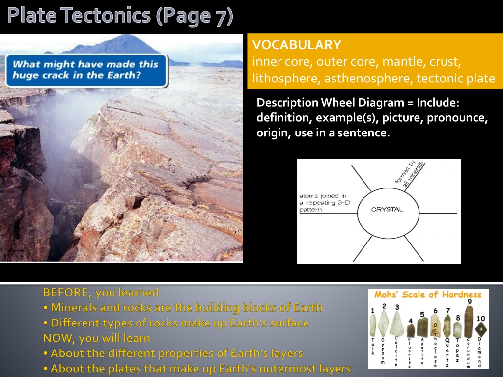
Plate Tectonics (Page 7) VOCABULARY inner core, outer core, mantle, crust, lithosphere, asthenosphere, tectonic plate Description Wheel Diagram = Include: definition, example(s), picture, pronounce, origin, use in a sentence.
*Key Concept Scientists think that about 4.6 billion years ago, Earth formed as bits of material collided and stuck together. The planet grew larger as more and more material was added. These impacts, along with radioactive decay and Earth's gravity, produced intense heat. The young planet became a glowing ball of melted rock. In time, denser materials, such as iron and nickel, sank toward the center of Earth. Less dense materials moved toward the surface. Other materials settled between the planet's center and its surface. Slowly, Earth's main layers formed the core, the mantle, and the crust.
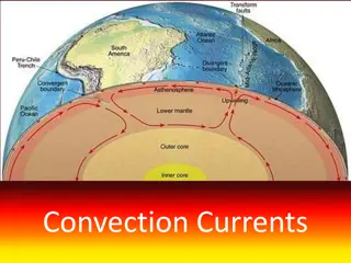
Earth's layers have different properties. EXPLORE Density How do scientists know what Earth's deep interior is like? After all, no one has seen it. To explore Earth s interior, scientists study the energy from earthquakes or underground explosions they set off. The energy travels through Earth somewhat like ripples move through a pond. The energy moves slower through less dense materials or liquids and faster through denser materials or solids. In this way, scientists infer what each layer is made of and how thick the layers are, as shown in the diagram on the next slide. QUESTION Will a denser material sink or float? PROCEDURE 1. Fill both cups half way. Add 3 spoonfuls of salt to one of the cups and stir until the salt is dissolved. 2. Add 8 drops of food coloring to the same cup in which you dissolved the salt. Stir again. 3. Very gently pour about a third of the colored salt water into the cup of fresh water. Observe what happens. MATERIALS 2 clear plastic cups tap water table salt plastic spoon food coloring WHAT DO YOU THINK? What did you observe when the two types of water were mixed? What does this activity tell you about materials of different density?
The core is Earth's densest region and is made up of two parts. The inner core is a ball of hot, solid metals. There is enormous pressure at the center of Earth. This squeezes the atoms of the metals so closely together that the core remains solid despite the intense heat. The mantle is Earth's thickest layer, measuring nearly 2900 kilometers (1700 mi). It is made of hot rock that is less dense than the metallic core. The very top part of the mantle is cool and rigid. Just below that, the rock is hot and soft enough to move like a thick paste. The crust is a thin layer of cool rock. It surrounds Earth somewhat like a shell surrounds an egg. There are two basic types of crust. Continental crust includes all continents and some major islands. Oceanic crust includes all the ocean floors. Earth's crust is thinnest under the oceans and thickest under continental mountain ranges. The crust is home to all life on Earth. The outer core is a layer of liquid metals that surrounds the inner core. The temperature and pressure in the outer core are lower than in the inner core. The lower pressure allows the metals to remain liquid.
Earth's crust and the very top of the mantle together form the lithosphere (LIHTH-uh- SFEER). The Greek prefix litho- means stone or rock. This layer is the most rigid of all the layers. The lithosphere sits on top of the asthenosphere (as- THEHN-uh-SFEER), a layer of hotter, softer rock in the upper mantle. The Greek word asthen smeans weak. This layer is not actually weak, but it is soft enough to flow slowly like hot tar. You can imagine the lithosphere as solid pieces of pavement resting on hot tar.
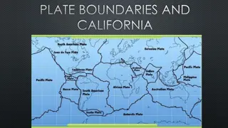
As scientists studied Earth's surface, they discovered that the lithosphere does not form a continuous shell around Earth. Instead, they found that the lithosphere is broken into many large and small slabs of rock called tectonic plates (tehk-TAHN-ihk). Scientists do not know exactly how or when in Earth's history these giant plates formed. Tectonic plates fit together like a jigsaw puzzle that makes up the surface of Earth. You could compare the lithosphere to the cracked shell of a hard-boiled egg. The shell may be broken into many pieces, but it still forms a crust around the egg itself. Most large tectonic plates include both continental crust and oceanic crust. Most of the thicker continental crust rises above the ocean. The rest of the plate is thin oceanic crust, or sea floor, and is underwater. The next time you look at the continents on a world map, remember you are seeing only the part of Earth's crust that rises above the ocean. Why do you see only the dry land areas of tectonic plates on a typical world map?
Plate Tectonics (Page 13) In the diagram, notice how much of the African Plate, shaded darker blue, lies underwater. The continent of Africa, which looks large on a world map, is actually about half the size of the entire plate. The plate's oceanic crust forms part of the sea floor of the Atlantic and Indian oceans and of the Mediterranean Sea. The ocean crusts of other plates make up the rest of the sea floors. Earth's layers and tectonic plates are two of the most important discoveries in geology. They helped solve a mystery that had puzzled people for nearly 400 years. The mystery involved two questions. Have the continents always been where they are today? If not, how did they move to their present positions?
KEY CONCEPTS 1. Briefly describe the inner and outer cores, the mantle, and the crust. (Density/composition) 2. In what ways is the litho-sphere different from the asthenosphere? 3. Describe the structure of most tectonic plates. CRITICAL THINKING 4.Draw Conclusions Suppose you are looking at a scene that has mountains near an ocean. Where do you think the crust would be the thickest? Why? (Draw it) 5.Hypothesize What would Earth look like if most of its crust was above sea level? CHALLENGE 6.Predict You have learned that Earth's lithosphere is made up of many plates. How do you think this fact might help scientists solve the mystery of the moving continents?
*Key Concept BEFORE, you learned Earth's main layers are the core, the mantle, and the crust The lithosphere and asthenosphere are the topmost layers of Earth The lithosphere is made up of tectonic plates
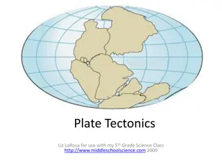
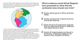
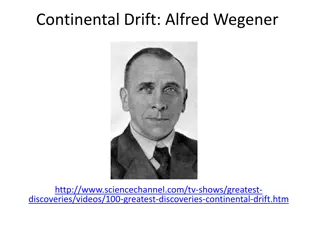
Continents join together and split apart. The idea that Earth's surface might be moving is not new. As far back as the 1500s, when mapmakers started including North and South America in their world maps, they noticed something curious. The western coast of Africa and the eastern coast of South America seemed to fit together like pieces in a puzzle. Were these continents joined at one time? EXPLORE Movements of Continents QUESTION How do you reconstruct a super continent? PROCEDURE 1. Work with a small group. Draw the outline of a large landmass. Fill in mountains, rivers, lakes, and any other features you like. Cut out your landmass, then tear the drawing into several pieces and mix the pieces up. Ask another group to put the puzzle together. In the late 1800s, German scientist Alfred Wegener (VAY-guh-nuhr) began studying this question. In 1912, he proposed a hypothesis known as continental drift. According to Wegener's hypothesis, Earth's continents were once joined in a single landmass and gradually moved, or drifted, apart. For many years, people did not accept Wegener's ideas. Not until the mid-1900s did scientists find new evidence that made them consider continental drift more seriously. 2. MATERIALS sheet of paper colored marking pens scissors WHAT DO YOU THINK? What clues helped you fit the pieces together? Do any lands on a world map seem to fit together?
Evidence for Continental Drift Wegener gathered evidence for his hypothesis from fossils, from studies of ancient climate, and from the geology of continents. Fossils Wegener learned that the fossils of an ancient reptile, Mesosaurus (MEHZ-uh-SAWR-uhs), had been discovered in South America and western Africa. This small reptile lived about 270 million years ago. Its fossils were not found anywhere else in the world. Wegener said this fact could easily be explained if South America and Africa were once joined, as shown in the map to the right. Climate Evidence of climate change also supported Wegener's hypothesis. For example, Greenland today lies near the Arctic Circle and is mostly covered in ice. Yet fossils of tropical plants can be found on its shores. In contrast, South Africa today has a warm climate. Yet its rocks were deeply scratched by ice sheets that once covered the area. Wegener suggested that these continents had moved, carrying their fossils and rocks with them. Greenland, for example, had once been near the equator and had slowly moved to the Arctic Circle. South Africa, once closer to the South Pole, had moved slowly north to a warmer region. Geology Wegener's best evidence for continental drift came from the kinds of rocks that make up the continents. He showed that the type of rock found in Brazil matched the rock found in western Africa. Also, limestone layers in the Appalachian Mountains of North America were exactly like the limestone in Scotland's Highlands . Which evidence for continental drift do you think is the most convincing? Explain your answer.
PANGAEA AND CONTINENTAL DRIFT For Wegener, all the evidence pointed to a single conclusion. The continents had once been joined in a huge supercontinent he called Pangaea (pan-JEE-uh). Pangaea comes from the Greek word meaning all lands. This giant continent reached from pole to pole and was centered over the area where Africa lies today. Pangaea began to split apart some 200 million years ago. In time, the continents moved to where they are today. Yet Wegener could not explain how the continents moved. Because of this, his critics called continental drift a fairy tale and rejected his hypothesis.
")


")