Understanding Natural Hazards and Plate Boundaries

Learn about natural hazards such as volcanic eruptions, earthquakes, and storms that pose risks to human populations. Discover how factors like urbanization, poverty, climate change, and farming increase vulnerabilities to these hazards. Explore plate boundaries, crust types, and examples of geological features like the Ring of Fire and the Mid-Atlantic Ridge.

Download Presentation

Please find below an Image/Link to download the presentation.
The content on the website is provided AS IS for your information and personal use only. It may not be sold, licensed, or shared on other websites without obtaining consent from the author. Download presentation by click this link. If you encounter any issues during the download, it is possible that the publisher has removed the file from their server.
E N D
Presentation Transcript
Image result for your memory GEOG GEOG YOUR YOUR MEMORY MEMORY
What is the definition of a natural hazard? A natural event that has a huge social impact (affects humans) Name three natural hazards Volcanic eruptions, earthquakes, storms, Tsunami, landslides, floods What factors increase the risk to people from natural hazards? (at least two) Urbanisation, poverty, Climate change, Farming Why does urbanisation increase risk from natural hazards? Over 50% worlds population live in cities. Some megacities Eg. Istanbul, L.A. and Tokyo suffer from earthquakes. Densely populated areas at risk from cyclones as many cities on the coast.
What do we call the belt of volcanoes around the edge of the Pacific Ocean? The Ring of Fire What are the two types of crust? Oceanic and continental Why does climate change increase risk from natural hazards? In a warmer world the atmosphere has more energy so = intense storms and hurricanes, some parts to become wetter (flooding). Others drier (droughts) How does farming increase risk from natural hazards? Living on floodplains for fertile soils after flooding, puts people at risk (Eg. Ganges Bangladesh)
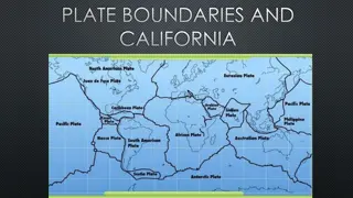
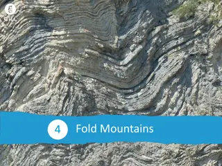
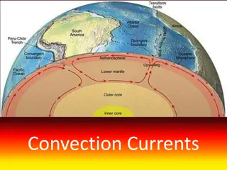
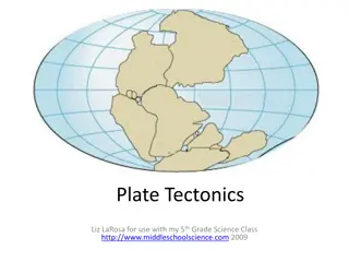
What is the plate margin called where the plates are moving passed each other? Conservative What is the plate margin called where the plates are moving towards each other? Destructive Which plate margin has no volcanoes? Conservative How does poverty increase risk from natural hazards? Poorer parts of the world forces people to live in risky areas. A shortage of housing leads people to build houses on unstable steep slopes prone to landslides and areas prone to flooding.
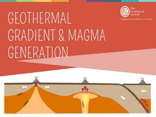
Which is denser (heavier)? Continental or oceanic crust? Oceanic Which can be destroyed and created? Continental or oceanic crust? Oceanic What is the plate margin called where the plates are moving away from each other? Constructive Give an example of where this is happening. Mid Atlantic ridge. North American and Eurasion plate What plate boundary is the San Andreas Fault? Conservative What plate boundary is Mount Vesuvius (Naples) on? Destructive
Name the plate boundaries where volcanoes happen. Constructive and destructive Name the plate boundaries where earthquakes happen. All of them How powerful were the Nepal and Chile earthquakes on the Richter scale? Chile 8.8 and Nepal 7.9 Name x3 differences in primary effects between the two earthquakes. Chile 500 people killed and 12000 injured. Nepal 9000 killed and 20000 injured. Chile 220000 homes destroyed. Nepal 3 million 4500 schools destroyed in Chile, 7000 in Chile No real disruption to food supplies in Chile. 1.4 million people needed food, water and shelter in Nepal and 50% shops destroyed in Nepal affecting food supplies. Chile cost $30 billion. Nepal cost $5 billion Nepal received international aid but Chile did not
What plate margins did the Chile earthquake occur at? Destructive plate margin Nazca and south American plate What plate margins did the Nepal earthquake occur at? Destructive plate margin Eurasion and Indo-Australian plate When did both earthquakes happen? Nepal 25thApril 2015 Chile 27thFebruary 2010 Name x3 secondary effects of each earthquake Chile 1500 km of roads destroyed landslides communities cutoff for days Tsunami hits coastal towns Tsunami warnings prevent loss of life Fire at chemical plant near Santiago meant area evacuated Nepal Landslides and avalanches = 19 people killed on mt Everest Landslide blocked Gandaki river, area evacuated fear of flooding No Tsnami because no coast.
What is the difference between effects and responses? Effects are things that happen as direct result of an event (hazard) What is the difference between primary and secondary effects? Primary occur at the moment the earthquake shakes the ground eg. Buildings collapsing, deaths injuries. Secondary are a result of the primary effects eg. Tsunami, fires, landslides List x3 differences between the immediate responses of the Chile and Nepal earthquake. Emergency services acted quickly in Chile to supply field hospitals, satellite phones and floating bridges. But Nepal international Search and rescue teams with water and medical support had to be flown in. Eg. UK and China Financial aid pledged from other countries for Nepal but Chile a national appeal raised $60 million and rest paid by own government, no need for international help. Chile restored90% power on 10 days, main highway running within 24 hours. Nepal half million tents needed for shelter, helicopters rescued people and delivered supplies to cut off villages. No national migration in Chile but 300000 people migrated to Katmandu in Nepal
Which is the richer country, Chile or Nepal Chile Give 2 reasons why people choose to live in tectonic hazard areas Fertile land by volcanoes, some may not be aware of the risks, some are confident in the warning systems from increased monitoring, earthquakes and volcanoes don t happen very often, people living in poverty have more pressing things to think about like food and work. Why live in Iceland on a plate boundary? Geothermal energy is cheap and no Co2, tourism from volcanoes, naturally occurring hot water, volcanic rocks used in construction List 3 differences in long term responses between the Nepal and Chile Earth quakes A month after the earthquake, Chile s government launched housing reconstruction plan to help 200000 households but Nepal thousands of homeless still needed housing. Chile rebuilt without international aid but Nepal hosted an international conference in June 2015 to seek financial support from other countries to rebuild. Chile took 4 years to fully recover from damage to buildings and ports. Nepal put stricter building controls in place to stop buildings collapsing in another earthquake happened
Name x2 ways volcanoes can be monitored Remote sensing from satellites detecting changes, seismicity to record earthquakes, changes to the shape of the land, changes in gravity as magma rises, detect gases released, detect gases dissolved in water hydrology Name x2 ways that earthquakes can be predicted Earthquakes happen without warning, so they cannot be predicted. However previous earthquakes and ground deformation can show signs of possible movement What are the names of the three cells in atmospheric global circulation? Polar, Hadley and ferrel List 3 main points that explains how atmospheric circulation works in the three cells Warm air rises at the equator and travels to around 30 North where it cools and sinks to the surface, before returning to the tropics. This movement is known as the Hadley cell. The Ferrel cell is found between the Hadley and Polar cells and lies between 60 North and 30 North. The Polar cell is much smaller. Cold air sinks at the North Pole, before flowing south at the surface. Here it is warmed by contact with land/ocean around 60 North, where it rises.
How can planning for a volcanic eruption reduce the risk? Exclusion zone on Montserrat keeps people permanently away from danger. How can planning for an earthquake reduce the risk? Building valuable land uses. Eg. Hospitals away from vulnerable areas. Build earthquake proof buildings How can we protect against earthquakes. Earthquake proof buildings and prepare how to act in the event of an earthquake eg. Earthquake or tsunami drills at school How are pressure belts affected by seasonal changes? The tilt of the earth causes changes in the overhead sun which causes pressure belts and winds to move north and south during seasons How does atmospheric circulation cause tropical storms? The trade winds in the tropics are driving towards each other and start the storm spinning.
Where do tropical storms form? Between latitudes 5 and 15 north and south What conditions does a tropical storm need to form? Oceans above 27 C, intense heat leading to unstable heat rising (low pressure) Converging trade winds causing it to spin Where hot air is rising, is it low or high pressure? Low pressure Where are the strongest winds in a tropical storm? The Eye wall In 4 bullet points, describe how tropical storms form? Strong upward movement of air draws up vapour from warm ocean (over 27 C Air cools and condenses to form thunderstorms and releases heat that powers the storms. Several thunderstorms join up and start spinning when winds reach 75 mph (officially a tropical storm Storm carried across the ocean by prevailing winds and eventually slows when energy supply is cut (cool water in higher latitudes), friction with land slows it
Tropical storms are also called. (three names) Cyclones, hurricanes, typhoons where cold air is sinking, is it low or high pressure? High pressure What is the Saffir-Simpson scale? Measures category of tropical storms from 1-5 Name at least 2 features of a tropical storm Eye, torrential rain, strong winds above 120km/hr, thunderstorms, What is the name of your tropical storm case study? Typhoon Haiyan, November 2013 in the Philippines Comment on the distribution, frequency and intensity of tropical storms into the future. All may increase as climate change raises global sea temperatures to higher latitudes.
What impact has building cyclone shelters in Bangladesh had? Deaths in 40 years decreased 100 fold from 500000 in 1970 to 4234 in 2007 How can tropical storms be monitored and predicted? Hurricane watch and hurricane warnings from the hurricane center in Miami Name x2 primary effects of Typhoon Haiyan 6300 killed, most drowned. 600000 people displaced. 40000 homes damaged or flattened. 90% Talclaban city destroyed and airport damaged. 30000 fishing boats destroyed, powerlines and crops destroyed. 400mm rain caused wide spread flooding Name x2 immediate responses to Typhoon Haiyan Other governments and aid agencies quickly responded with food, water and tents.US aircraft carrier George Washington and helicopters assist in rescue and aid delivery. 1200 evacuation centres for the homeless. UK sent shelter kits to provide for a family. French , Belgium and Israeli hospitals set up to help the injured. Philippines red cross delivered basic food aid.
Name 2 ways people can be protected from tropical storms Windows and doors reinforced, storm drains constructed in urban areas, sea walls. Coastal buildings on stilts. 2000 cyclone shelters in Bangladesh How can we plan for a tropical storm? USA national Hurricane preparedness week on TV and in schools. Building away from areas at risk Name x2 secondary effects of Typhoon Haiyan 6 million lost their source of income, 14 million affected and many of them homeless. Landslides blocked roads and cut off rural communities. Lost power for a month. Ferry services disrupted which slowed down aid. Looting and violence broke out in Tacloban. Name x2 Long-term responses to Typhoon Haiyan UN donated financial aid, supplies and medical support. Rebuilt roads, bridges and airport. cash for work programmes people paid to help clear the debris. Rich countries (US, Australia and EU) supported new livelihood opportunities. Rice farming and fishing quickly re-established. Coconut production will take longer as takes 5 years to grow. Oxfam supported the replacement of fishing boats. 1000s of home built away from areas at risk from flooding. More cyclone shelters built to accommodate people evacuated from coastal areas.
What was our UK weather hazard case study? The Somerset Levels floods 2014 What are the UKs weather hazards? At least 2 Thunderstorms, Prolonged rainfall, drought and extreme heat, heavy snow and extreme cold, strong winds What caused the flooding? At least 2 points Wettest January since records began in1910, 350mm fell in January and February, 100mm more than usual, high tides and storm surges swept up rivers from the Bristol channel preventing fresh water reaching the sea and flooding land instead, rivers not being dredged for 20 years mean the river bed had risen. What were the economic impacts of the floods? Flood damage more than 10 million, 14000 ha agricultural land underwater for 3-4 weeks., 1000 livestock evacuated, local road cut off by flooding, Bristol to Taunton railway line closed at Bridgewater.
Name a period of drought and extreme heat in the UK. 2003 most extreme heatwave for 500 years hit Europe and 20000 died. World cup 2018 summer where hose pipe bans came into force and the grass started dying. Name an extreme cold and snow event. The beast from the East March 2018 What were the social impacts of the Somerset floods? 600 homes flooded, 16 farms evacuated, people living in temporary accommodation for several months, Moorland and Muchelney villages cut off affecting daily lives of jobs and education, power supplies cut off. What were the environmental impacts of the Somerset floods? Floodwaters heavily contaminated with sewage and oil and chemicals, debris needed clearing, stagnant water had to be reoxygenated before being pumped back into rivers
Geog Your memory How much did the Somerset flood Action Plan cost? 20 million What are the names of the 2 rivers on the Somerset levels? Tone and Parratt How long did the floodwaters stay for on the Somerset levels in 2014? 3-4 weeks What did the residents in Somerset blame the extent of the flooding on? That the rivers hadn t been dredged for 20 years Name 2 ways the flood Action Plan did to minimise impacts of future flooding? Raised the roads Dredged the rivers Build flood defences around villages Built more pumping stations A tidal barrage is planned in Bridgewater
Geog Your Memory Give 2 pieces of evidence that there is climate change Extraction of ice cores in Antarctica tells us that temperatures have fluctuated above and below today s temperatures over millions of years. Glaciers are retreating, sea levels have risen10-20 cm in last 100 years. Seasonal weather patterns are changing Give a natural reason for climate change and explain it Orbital changes, explained by the Milankovich cycle means that eccentricity the Earth passes by the sun closer during an elliptical 100000 year cycle, making the Earth hotter and colder at times. Sunspots are where flares of energy are releases by the sun
What does the word mitigation mean? How humans can reduce the risk What is adaptation? How humans will adapt their lifestyles to the impending change
How were the floods managed? What evidence is there that weather in the UK is becoming more extreme?


? Continental or oceanic crust?")


")