Regional Fire Inventory Data Collection and Analysis Framework
This comprehensive document outlines the data elements, calculation stream, and procedural steps required for WESTAR-WRAP agencies to contribute to the regional fire inventory. It covers aspects such as event reporting, emissions verification, fire type characteristics, fuel information, consumption modeling, emission factors, and emissions inventory creation. Suggestions for implementing these steps based on agency expertise and resources are provided, along with a list of subject matter experts to consult for further development.

Download Presentation

Please find below an Image/Link to download the presentation.
The content on the website is provided AS IS for your information and personal use only. It may not be sold, licensed, or shared on other websites without obtaining consent from the author. Download presentation by click this link. If you encounter any issues during the download, it is possible that the publisher has removed the file from their server.
E N D
Presentation Transcript
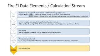
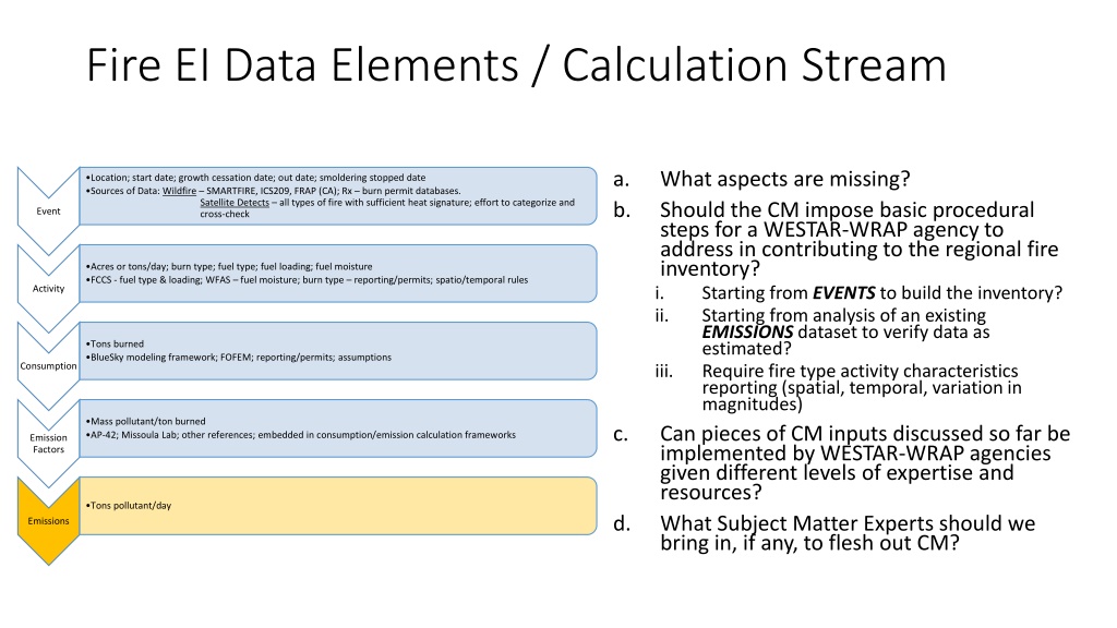
Fire EI Data Elements / Calculation Stream a. b. What aspects are missing? Should the CM impose basic procedural steps for a WESTAR-WRAP agency to address in contributing to the regional fire inventory? i. Starting from EVENTS to build the inventory? ii. Starting from analysis of an existing EMISSIONS dataset to verify data as estimated? iii. Require fire type activity characteristics reporting (spatial, temporal, variation in magnitudes) Can pieces of CM inputs discussed so far be implemented by WESTAR-WRAP agencies given different levels of expertise and resources? What Subject Matter Experts should we bring in, if any, to flesh out CM? Location; start date; growth cessation date; out date; smoldering stopped date Sources of Data: Wildfire SMARTFIRE, ICS209, FRAP (CA); Rx burn permit databases. Satellite Detects all types of fire with sufficient heat signature; effort to categorize and cross-check Event Acres or tons/day; burn type; fuel type; fuel loading; fuel moisture FCCS - fuel type & loading; WFAS fuel moisture; burn type reporting/permits; spatio/temporal rules Activity Tons burned BlueSky modeling framework; FOFEM; reporting/permits; assumptions Consumption Mass pollutant/ton burned AP-42; Missoula Lab; other references; embedded in consumption/emission calculation frameworks c. Emission Factors Tons pollutant/day d. Emissions
WFEIS Total MODIS pixels burned per day, or Total wildfire perimeter acres per event, or User-submitted event data (any burn type) Cannot explicitly return daily emissions by fire type Location; start date; growth cessation date; out date; smoldering stopped date Sources of Data: Wildfire SMARTFIRE, ICS209, FRAP (CA); Rx burn permit databases. types of fire with sufficient heat signature; effort to categorize and cross-check Satellite Detects all Event Acres or tons/day; burn type; fuel type; fuel loading; fuel moisture FCCS - fuel type & loading; WFAS fuel moisture; burn type reporting/permits; spatiotemporal rules Uses best-available fuels and moisture information Daily fuel moisture (WFAS) FCCS or NAWFD Activity Uses FFT Consume Consume Tons burned BlueSky modeling framework; FOFEM; reporting/permits; assumptions Consumption Uses recent EFs from PNW Airfire grp Mass pollutant/ton burned AP-42; Missoula Lab; other references; embedded in consumption/emission calculation frameworks Consume FFT Emission Factors Totals are by dataset, cannot parse fire type By bounding box, state, or county Total emissions for selected time period Daily emissions (if MODIS selected) Tons pollutant/day Emissions Inventory
2 Years 1 Year 6 months Real-Time MODIS MCD64A1 HMS Location; start date; growth cessation date; out date; smoldering stopped date Sources of Data: Wildfire SMARTFIRE, ICS209, FRAP (CA); Rx burn permit databases. types of fire with sufficient heat signature; effort to categorize and cross-check Satellite Detects all SMARTFIRE v2 Event FRAP Database Annual Fire Geography Default Fire Geography NIFS MTBS (InForms) Acres or tons/day; burn type; fuel type; fuel loading; fuel moisture FCCS - fuel type & loading; WFAS fuel moisture; burn type reporting/permits; spatiotemporal rules FCCS/EVT Grid NASF Activity LANDFIRE Vintage NPS NAWFD SMP Permits WFAS Tons burned BlueSky modeling framework; FOFEM; reporting/permits; assumptions fuel moisture Burn Severity Consumption FINN CONSUME BlueSky Pipeline Mass pollutant/ton burned AP-42; Missoula Lab; other references; embedded in consumption/emission calculation frameworks Emission Factors SERA FEPS FOFEM Tons pollutant/day Emissions Inventory Level 0 Level 1 Level 2 Primary Data/Tool Helper or Enhancer
2 Years 1 Year 6 months Real-Time MODIS MCD64A1 HMS Location; start date; growth cessation date; out date; smoldering stopped date Sources of Data: Wildfire SMARTFIRE, ICS209, FRAP (CA); Rx burn permit databases. types of fire with sufficient heat signature; effort to categorize and cross-check Satellite Detects all SMARTFIRE v2 Event FRAP Database Annual Fire Geography Default Fire Geography NIFS MTBS (InForms) Acres or tons/day; burn type; fuel type; fuel loading; fuel moisture FCCS - fuel type & loading; WFAS fuel moisture; burn type reporting/permits; spatiotemporal rules FCCS/EVT Grid NASF Activity LANDFIRE Vintage NPS NAWFD SMP Permits WFAS Tons burned BlueSky modeling framework; FOFEM; reporting/permits; assumptions fuel moisture Burn Severity Consumption FINN CONSUME BlueSky Pipeline Mass pollutant/ton burned AP-42; Missoula Lab; other references; embedded in consumption/emission calculation frameworks Emission Factors SERA FEPS FOFEM Tons pollutant/day Emissions Inventory Level 0 Level 1 Level 2 WFEIS Primary Data/Tool Helper or Enhancer
2 Years 1 Year 6 months Real-Time MODIS MCD64A1 HMS Location; start date; growth cessation date; out date; smoldering stopped date Sources of Data: Wildfire SMARTFIRE, ICS209, FRAP (CA); Rx burn permit databases. types of fire with sufficient heat signature; effort to categorize and cross-check Satellite Detects all SMARTFIRE v2 Event FRAP Database Annual Fire Geography Default Fire Geography NIFS MTBS (InForms) Acres or tons/day; burn type; fuel type; fuel loading; fuel moisture FCCS - fuel type & loading; WFAS fuel moisture; burn type reporting/permits; spatiotemporal rules FCCS/EVT Grid NASF Activity LANDFIRE Vintage NPS NAWFD SMP Permits WFAS Tons burned BlueSky modeling framework; FOFEM; reporting/permits; assumptions fuel moisture Burn Severity Consumption FINN CONSUME BlueSky Pipeline Mass pollutant/ton burned AP-42; Missoula Lab; other references; embedded in consumption/emission calculation frameworks Emission Factors SERA FEPS FOFEM Tons pollutant/day Emissions Inventory Level 0 Level 1 Level 2 CARB Primary Data/Tool Helper or Enhancer
2 Years 1 Year 6 months Real-Time MODIS MCD64A1 HMS Location; start date; growth cessation date; out date; smoldering stopped date Sources of Data: Wildfire SMARTFIRE, ICS209, FRAP (CA); Rx burn permit databases. types of fire with sufficient heat signature; effort to categorize and cross-check Satellite Detects all SMARTFIRE v2 Event FRAP Database Annual Fire Geography Default Fire Geography NIFS MTBS (InForms) Acres or tons/day; burn type; fuel type; fuel loading; fuel moisture FCCS - fuel type & loading; WFAS fuel moisture; burn type reporting/permits; spatiotemporal rules FCCS/EVT Grid NASF Activity LANDFIRE Vintage NPS NAWFD SMP Permits WFAS Tons burned BlueSky modeling framework; FOFEM; reporting/permits; assumptions fuel moisture Burn Severity Consumption FINN CONSUME BlueSky Pipeline Mass pollutant/ton burned AP-42; Missoula Lab; other references; embedded in consumption/emission calculation frameworks Emission Factors SERA FEPS FOFEM Tons pollutant/day Emissions Inventory Level 0 Level 1 Level 2 2014NEI Primary Data/Tool Helper or Enhancer
2 Years 1 Year 6 months Real-Time MODIS MCD64A1 HMS Location; start date; growth cessation date; out date; smoldering stopped date Sources of Data: Wildfire SMARTFIRE, ICS209, FRAP (CA); Rx burn permit databases. types of fire with sufficient heat signature; effort to categorize and cross-check Satellite Detects all SMARTFIRE v2 Event FRAP Database Annual Fire Geography Default Fire Geography NIFS MTBS (InForms) Acres or tons/day; burn type; fuel type; fuel loading; fuel moisture FCCS - fuel type & loading; WFAS fuel moisture; burn type reporting/permits; spatiotemporal rules FCCS/EVT Grid NASF Activity LANDFIRE Vintage NPS NAWFD SMP Permits WFAS Tons burned BlueSky modeling framework; FOFEM; reporting/permits; assumptions fuel moisture Burn Severity Consumption FINN CONSUME BlueSky Pipeline Mass pollutant/ton burned AP-42; Missoula Lab; other references; embedded in consumption/emission calculation frameworks Emission Factors SERA FEPS FOFEM Tons pollutant/day Emissions Inventory Level 0 Level 1 Level 2 IDEQ WF Primary Data/Tool Helper or Enhancer
2 Years 1 Year 6 months Real-Time MODIS MCD64A1 VIIRS AFP HMS Location; start date; growth cessation date; out date; smoldering stopped date Sources of Data: Wildfire SMARTFIRE, ICS209, FRAP (CA); Rx burn permit databases. types of fire with sufficient heat signature; effort to categorize and cross-check Satellite Detects all SMARTFIRE v2 Event FRAP Database Annual Fire Geography Default Fire Geography NIFS MTBS (InForms) Acres or tons/day; burn type; fuel type; fuel loading; fuel moisture FCCS - fuel type & loading; WFAS fuel moisture; burn type reporting/permits; spatiotemporal rules FCCS/EVT Grid NASF Activity LANDFIRE Vintage NPS NAWFD SMP Permits WFAS Tons burned BlueSky modeling framework; FOFEM; reporting/permits; assumptions fuel moisture Burn Severity Consumption FINN CONSUME BlueSky Pipeline Mass pollutant/ton burned AP-42; Missoula Lab; other references; embedded in consumption/emission calculation frameworks Emission Factors SERA FEPS FOFEM Tons pollutant/day Emissions Inventory Level 0 Level 1 Level 2 CMFD Level 1?? Primary Data/Tool Helper or Enhancer