Satellite Communications and Orbits in Engineering

University of Diyala
College of Engineering
Department of Communications
Engineering
Satellite Communications
By:
Dr. Majidah Hameed
Majeed
Lecture # 2
1.5 Spe
c
ial 
Types
 
of
 
Inclined Orbit
s
. 
A
 
sa
t
ellite
 
orbiting
 
in
 
a
 
plane
 
that
 
coincides
 
with
 
the
 
equatorial
 
plane
 
of
 
the
 
e
a
rth
 
is
in
 
an EQ
U
ATORIAL
 O
R
B
I
T.
 
A
 satellite
 
orbiting
 
in
 
an inclined
 
orbit with
 
an ang
l
e
of
 
inclination
 
of
 
90
 
degre
e
s
 
or
 
near
 
90
 
d
e
gre
e
s
 
is
 
in
 
a
 
POLAR
 
OR
B
IT.
 
As
 
shown
in 
fig 1.8
fig
 
1.8
1.6 
 
The
 
Elli
ptic 
Orbit
The
 
only
 
orbit type we
 
will
 
discuss
 
here 
is
 
the
 
elliptic 
orb
i
t
 
as
 
s
hown in
 
fig
 
(
 
1.
9)
.
 
All
 
sa
t
ellites
 
that
 
orbit 
 
around
 
the
 
E
a
r
t
h
 
are
 
in
 
a
 
elliptic
 
orbit. 
 
A
 
parabolic
 
and
hyperbolic 
 
orbit 
 
are 
 
no
n
-periodic, 
 
and 
 
hence 
 
represent 
 
esca
p
e 
 
orbits, 
 
that 
 
is, 
 
the
satellite
 
in
 
these
 
orbits
 
leaves
 
t
he
 
Earth.
 
The
 
para
b
olic
 
orbit
 
is
 
the
 
m
ini
m
u
m
 
energy
esc
a
p
e
 orbit.
fig
 
1.9
In the
 
figure
 
we
 
can
 
identify
 
the following
 ite
m
s:
Occupied
 
focus
loc
a
tion
 
of the
 
Earth
 
or
 
c
e
ntral 
attracting body
a 
 
= 
 s
e
m
i
-
ma
jor
 
axis
e
 
= 
 
orbit
 
e
c
centricity
 
(
0<e<1
 for
 
elliptic orbits, 
e
 
=
 
0
 is 
 
circular
 orbit)
Note
 
that 
r is 
measured
 fro
m
 the
 
center
 
of
 
the
 
E
a
rt
h
, 
hence
 
we
 
c
an
 
note
 that:
where
 
h =
 
height
 
abo
v
e 
Earth’s
 
surfa
c
e, 
R
e
 
=
 
earth radi
u
s
Often 
 
t
i
me
s 
 
the 
 
pe
r
igee 
 
and 
 
apogee 
 
d
i
stances 
 
are 
 
given 
 
in 
 
te
r
m
s 
 
of 
 
the 
 
height
above
 
the
 
E
a
rth’s
 
surface.
 
This
 
is
 
not
 
corre
c
t,
 
and
 
the
 
radi
u
s
 
of
 
the
 
E
a
rth
 
m
ust
 
b
e
added
 
to
 
the
 
height
 
to get
 
the
 
perigee
 
and
 
apogee
 radii.
The
 
polar
 
equation
 
for
 
the
 elliptic 
or
bit, 
with
 th
e
 
origin
 at 
one
 
focus
 is 
given
 
by:
…………….(1)
...
……………….(2)
………………..(3)
Example
The 
 
inte
r
national 
 
spa
c
e 
 
stat
i
on 
 
is 
 
in 
 
a 
 
“372 
 
x 
 
381 
 
km 
 
orbit”, 
 
what 
 
is 
 
the
ecc
e
ntricity
 
of
 th
e
 
orbit?
Solution:
The
 
two
 
n
u
m
bers
 
re
f
er
 
to
 
the
 
peri
g
ee
 
he
i
ght
 
(372
 
k
m
)
 
and
 
the
 
apogee
 
height
 
(381
k
m
). 
 
However, 
 
these 
 
are 
 
the 
 
heights 
 
above 
 
the 
 
E
a
rth’s 
 
surfa
c
e 
 
and 
 
m
ust 
 
be
converted
 
to perigee
 
and
 
apogee
 radii 
by 
a
dding
 
the E
a
rth’s 
radius.
Hence
 
the
 
internati
o
n
a
l 
space
 
station 
is 
in a
 
near
 
c
irc
u
lar orbit.
In 
 
or
d
e
r 
 
to 
 
fin
d 
 
the 
 
a
pog
e
e 
 
a
n
d 
 
p
e
rig
e
e 
 
h
e
i
gh
t
. 
 
T
h
e 
 
l
e
ng
th 
 
of 
 
th
e 
 
r
a
d
iu
s
v
ec
tors 
 
at 
a
pog
ee 
a
n
d
 
per
i
g
ee 
c
an
 
be 
obt
a
in
e
d
 
from
 
th
e
 
ge
o
m
e
t
ry
 
of 
th
e
 
el
l
ip
s
e:
from  equation
 
(2)
 
, 
W
h
ere
 r
a
:  
ra
d
iu
s
 
v
e
c
t
or at 
a
po
gee
p
e
rig
ee
r
p
 
:
 
rad
i
us
 
v
e
c
t
or
 at
e
 :
 
E
cc
e
ntr
i
c
it
y
T
h
e
n
 
w
e
 
can
 
calc
ul
a
t
e
 
h
a
 
a
n
d
 
h
p
 
a
s
 
fo
l
l
o
w
:
1.7  
 
C
i
rcular
 
Orb
i
ts
We 
 
sta
t
ed 
 
previously 
 
that 
 
a 
 
circular 
 
orbit 
 
is 
 
a 
 
special 
 
type 
 
of 
 
elliptical 
 
orbit. 
 
It
should
 
realize
 
a
 
circular
 
orbit
 
is
 
one
 
in
 
which
 
the
 
ma
jor
 
and
 
m
inor
 
ax
i
s
 
distances
are
 
equal
 
or
 
approxi
ma
tely
 
equal.
 
Mean
 
height
 
above
 
e
a
rth,
 
i
nstead
 
of
 
peri
g
ee
 
and
apoge
e
,
 
is
 
used
 
in
 
descri
b
ing
 
a
 
circular
 
orbit.            
 
A
 
sa
t
ellite
 
in
 
a
 
circu
l
ar
 
orbit
 
at
a
 
height
 
of
 
approxi
m
ately
 
36000
 
Km  
 
above
 
the
 
earth
 
is
 
in
 
a
 
synchronous
 
orbit.
 
At
this 
 
altitude 
 
the 
 
peri
o
d 
 
of 
 
rotation 
 
of 
 
the 
 
satellite 
 
is 
 
24 
 
hours, 
 
the 
 
sa
m
e 
 
as 
 
t
he
rotation
 
p
e
rio
d
 
of
 
the
 
e
a
rth.
 
In
 
other
 
wor
ds,
 
the
 
orbit
 
of
 
the
 
satellite
 
is
 
in
 
sync
 
w
i
th
the
 
rotational
 
m
otion
 
of
 
the
 
e
a
r
th.
 
Although
 
inclined
 
and
 
polar
 
synchro
n
ous
 
orbits
are
 
possible,
 
the
 
te
r
m
 
synchronous
 
usually
 
refers
 
to
 
a
 
synchronous
 
equatorial
 
orbit.
In
 
this
 
type
 
of
 
orbit,
 
satellites
 
appear
 
to
 
hover
 
m
o
t
ionlessly
 
in
 
the
 
sky.
 
Fi
g
ure
 
1-8
shows
 
how
 
one
 
of
 
t
hese
 
satellites
 
can
 
p
r
ovide
 
coverage
 
to
 
al
m
ost
 
half
 
the
 
surface
of 
the
 
e
a
r
t
h.
Fi
g
ure
 1
-8
 - Illu
m
ination
 
from
 
a
 
synchronous
 satellite.
Three
 
of
 
t
hese sa
t
ellites
 
c
a
n
 
p
r
ovide
 
coverage
 
over
 
m
ost of
 
the
 
earth
 
(except for
 
the
extre
m
e
 
n
orth
 
and
 
south
 
polar
 
regi
ons).
 
A
 
polar
 
projection
 
of
 
the
 
global
 
covera
g
e
of 
a
 
thre
e
-
satellite 
syst
e
m
 
is 
shown in
 
figure
 
1-9.
Fi
g
ure
 1-
9
. - 
Worldwide
 
sy
n
chronous
 satellite 
system
 
viewed
 
from
 
a
bove
 
the
North
 
Pol
e
.
1.8 
Ke
pl
e
r's
 
La
w
:
Johann
 
Kepler
 
deter
m
in
ed
 
three
 
laws
 
chara
c
terizing
 
orbital
 
moti
o
n,
 
These
 
laws
 
c
a
n
be 
 
proven 
 
ma
thematically 
 
using 
 
Ne
w
ton's 
 
law 
 
of 
 
gravitation. 
 
Kepler's 
 
laws 
 
are
paraphrased
 
below
 
along
 
with
 
the
 
corresponding
 
p
h
ysical
 
i
m
plications.
 
These
 
laws
apply
 
dir
e
ctly
 
to
 
satellite 
orbit
a
l 
m
otion, thus
 
the
 
laws are
 f
r
om the
 
point
 
of
 
view
 
of
an
 
Eart
h
-orbiting 
satellite.
Ke
pl
e
r's
 
First
 
L
a
w:
Satellite 
orbits
 
are
 
e
lliptical 
Paths with
 
the
 
E
a
rth
 
at
 
one
 
focus of
 
the
 ell
i
pse
Ke
pl
e
r's
 
Second
 
L
a
w
:
A
 
line
 
be
t
ween
 
the
 
center
 
of
 
the
 
Earth
 
and
 
the
 
sate
l
lite
 
sweeps
 
out
 
equal
 
areas
 
in
equal
 
inte
r
vals
 
of
 
time.
Ke
pl
e
r's
 
Third
 
L
a
w
:
The
 
square
 
of
 
the
 
orbital
 
period
 
is
 
proportional
 
to
 
the
 
cube
 
of
 
the
 
the
 
orbit's
 
semi
major
 
axis.
9.
Elev
atio
n
 
angle –
T
he 
 
angle 
 
f
rom 
 
th
e 
 
hor
i
z
o
n
tal 
 
to 
 
the 
 
point 
 
on 
 
the 
 
center 
 
of 
 
the 
 
main
beam
 
of
 
the
 
antenna
 
w
h
en
 
the
 
antenna
 is 
poin
t
ed
 
dire
c
tly
 
at the
 satellite
Cove
r
age 
 
angle 
 
- 
 
the 
 
measure 
 
of 
 
the 
 
portion 
 
of 
 
the 
 
e
arth's 
 
surface
visible
 
to
 
the
 satellite
Reaso
n
s 
 
affecting 
 
minimum 
 
elevation 
 
angle 
 
of 
 
earth 
 
st
a
tion’s 
 
antenna
o
(>0
 
)
Buildin
gs, 
 
tre
e
s, 
 
and 
 
other 
 
terrestrial  objects 
 
bl
o
ck 
 
the 
 
line 
 
of
sight
Atmosphe
r
ic 
attenuati
o
n
 is 
g
r
eater
 
at
 lo
w
 
elevation
 
angles
Electrical 
 
noise 
 
generated 
 
b
y 
 
the  earth's 
 
heat 
 
near 
 
its 
 
surface
adversely
 
affects
 
recep
t
ion
Fi
g
ure
 1-
1
0.
 
Elevati
o
n
 
angle
Or
bit
 
He
i
ght 
 
h
Cove
r
age
 
Angle  β
Elevation
 
Angle
 
θ
𝑹
𝑹+ 𝒉
=
𝐜𝐨𝐬(𝜷+ 𝜽)
𝐜𝐨𝐬(𝜽)
Ex
 :
A
 
sa
t
ellite
 
at
 
a
 
distance
 
of
 
10000 
 
k
m
 
from
 
a
 
point
 
on
 
the
 
earths
 
surfa
c
e
 
,
 
t
h
e
Cove
r
age
 
Angle  
 
β
 
=  
 
4
 
draw
 
and
 
fin
d
 
the
 
Elevation
 
Angle
 
θ.
 
R=
6378 
*
��
𝟑
km
Fc
 
=
 
(
m
v
2
)/r
1.10 The
 
Forces
 
Acting
 
on Satellite
When
 
a
 
satellite
 
is
 
launched,
 
it
 
is
 
pla
c
ed
 
i
n
 
orbit
 
around
 
the
 
Earth.
 
The
 
Earth's
 
gravity
holds
 
the
 
satellite
 
in
 
a
 
c
e
rtain
 
path
 
as
 
it
 
goes
 
around
 
the
 
E
a
r
th,
 
and
 
that
 
path
 
is
 
called
an
 
"or
bit."
There
 
are
 
t
wo  
 
ma
in
 
forces
 
a
c
t
i
ng
 
on
 
satellite
 
:
 
a
 
c
e
ntrifugal  
 
force
 
due
 
t
o
 
the
 
kinetic
energy
 
of
 
the
 
satellite,
 
wh
i
ch
 
atte
m
pts
 
to
 
fling
 
the
 
satellite
 
into
 
a
 
higher
 
orbit.
 
A
n
d
 
a
c
e
ntripetal
 
force
 
due
 
to
 
gravitational
 
attraction
 
of
 
the
 
planet
 
about
 
which
 
satelli
t
e
 
is
orbiting, 
 
which 
 
atte
m
pts 
 
to 
 
pull 
 
the 
 
sa
t
ellite 
 
down 
 
forward 
 
the 
 
planet. 
 
If 
 
these 
 
two
forces
 
a
re
 
equal,
 
the
 satellite 
will
 re
m
ain
 
i
n
 
stable
 orbit.
The
 
fo
r
m
ula
 
f
or 
 
centrifugal 
 
for
c
e
 is:
42,300k
m
. 
Since the radi
u
s
 
of 
t
he
 
Earth
 
is 
6
3
78 km the
 
heig
ht 
of the
 
geostationary
The
 
fo
r
m
ula
 
for
 
the
 
gravitational
 
force
 
be
t
ween
 
two
 
bodies
 
of
 
m
ass
 
M a
n
d
 
m
is
Fg=
 
(GM
m
)
/
r
2
Where  
M 
is 
the
 
mass
 
of the
 
Eart
h,  
m
 
is 
t
he 
ma
ss of
 th
e
 satell
i
te
G
 
(Newton's
 
Gravitational
 
Constant,
 r is
 
the
 
orbital
 
radius
v
 
the
 
speed
 
of
 satellite.
For
 
the
 satellite 
stable
 
in or
bit ,  
Fc=
 
Fg,
 
then
(m
v
2
/r) 
=
 
(GMm)/r
2
v
2
/r 
=
 
(GM
)
/
r
2
No
w
, 
v = 
 
2πr  
/
T
then
(2πr/
T
)^2 
 
/r
 
= GM
 
/r^2
=>
 (4
π
 
2  
 
r)/
T
2 
 
=
 (
GM)/r
2
=>
 
r
3 
 
=
 
(
GMT
2
)/4
π
2
We
 
know
 
that
 
T
 is o
ne
 
day,
 
since 
this is 
the
 
period
 
of
 
the
 
E
a
r
t
h.
 
This 
is
 
8.64
 
x
1
0
4 
 
seconds. We
 
also know
 
that
 
M
 
is th
e
 
mass
 
of the
 
Eart
h, 
which
 is
  
6
 
x
1
0
24 
 
kg.
L
a
stly, 
we
 
know
 
that
 
G
 (N
ewton's
 
Gravitational
 
Constant) 
is
11 
 
m
3
/kg.
s
2
So we
 
c
a
n
 
work
 
out
 
r.
r
3 
 
=
 
7.57
 
x 1
0
22
Therefore,
 r 
=
 
4.23 x
 
1
0
7 
 
=
 
42,3
0
0
 
k
m
.
6.67
 
x 1
0
-
So the
 
orbital
 
radius required
 
for a
 
geostationary,
 
or geosynchronous
 
orbi
t is
orbit
 
above
 
the
 
Eart
h
'
s
 
surface
 is 
~36
0
00
 
k
m
.
Fig
 
1.11
Gravitati
o
nal
 
force
 
i
s
 
inversely
 
pr
o
portional
 
to
 
the
 
square
 
of
 th
e
 
distance
 
between
 th
e
c
e
nters
 
of
 
gravity of
 
the
 
sat
e
llite 
and
 
the
 p
lanet
 
the
 satellite is 
orbiting,
 
in
 this 
case
 
the
e
a
rth.
The
 
gravitational
 
for
c
e
 
inward
 (
F
I
N
, 
the centripetal
 
force =
 
Fc)
 
is 
directed
 
toward the
c
e
nter
 
of
 g
ravity
 
of
 
the
 
earth.
The
 
kinetic
 
energy of
 th
e
 satel
l
ite 
(
F
OU
T
, 
the
 
centrifugal
 fo
rc
e
=
 
F
g) is 
dir
e
cted
opposite
 
to the
 
gravitational
 
force.
 
Kinet
i
c
 
energy 
is 
p
r
oportional
 
to
 th
e
 
square
 
of
 th
e
velocity
 
of the
 satell
i
te. 
When
 
t
hese
 
inwa
r
d
 
and outward
 
forces 
a
re
 b
alanc
e
d,
 
the
satellite 
moves
 
a
round
 
the
 
e
a
rth
 
in
 
a
 
“free
 fall” trajec
tory:
 
the
 satellite’s 
or
bit.
Fig
 
1.12 The
 
forc
e
s
 actin
g
 
on
 satellite
1.
1
1 
Or
b
i
tal
 
V
e
lo
c
i
ty
T
h
e 
 
v
e
lo
c
it
y 
 
r
e
q
ui
re
d 
 
t
o 
 
m
a
i
n
t
a
i
n 
 
a 
 
s
a
t
e
llit
e 
 
a
t 
 
th
e 
 
o
rbit 
 
r
a
d
iu
s 
 
r 
 
ca
n 
 
b
e
ca
l
c
ul
a
t
e
d
 
as
 fo
llo
w
:
-
D
e
p
e
nd
i
n
g
 
o
n
 
th
e
 
l
a
w
s
 
of
 
m
oti
o
n
 
f
i
rst
 
d
e
v
e
lo
pe
d
 
b
y
 
K
e
pl
er
 
a
n
d 
 
N
e
w
t
o
n
.
 
T
h
e
c
o
m
p
e
t
in
g
 
f
o
rces a
c
t
 
o
n
 
th
e 
s
a
t
e
ll
i
t
e
;
 
gr
a
v
it
y 
t
e
n
d
s
 
to
 
pull
 
th
e 
s
a
t
e
ll
i
t
e
 
in
 to
w
a
rd
s
th
e
 ea
rth,
 
w
h
i
l
e
 i
t
s 
orb
i
t
a
l
 
v
e
l
o
c
it
y
 t
e
n
d
s to
 
pu
l
l
 
th
e
 
s
a
t
e
llit
e
 
a
w
a
y
 fro
m 
t
h
e
 
ear
t
h,
a
s
 
in
 
1.13
T
h
e 
 
g
r
a
v
i
t
a
t
i
o
n
a
l 
 
f
o
r
c
e
, 
 
F
in, 
 
a
n
d 
 
t
h
e 
 
a
ng
u
l
a
r 
 
vel
o
c
it
y 
 
fo
r
c
e
, 
 
F
out, 
 
can 
 
b
e
r
e
pr
e
s
en
t
e
d
 
a
s:
For
 
the
 satellite 
stable
 
in or
bit ,  
F
c( 
Fin
 ) 
=
 
Fg
 
(Fo),
 
then
(m
v
2
/ 
=(GMm)/
r
2
v
2
/r 
=
 
(GM
)
/
r
2
Where
 
v
 
: satellite 
velocity
 
for
 
circular
 
or
bit 
in k
m
/sec
F
i
g
ure
 
1.1
3
 
F
or
c
e
s
 
a
c
ti
n
g
 
o
n
 
a
 
s
a
t
e
l
l
i
te
N
ot
e 
 
th
a
t 
 
for 
 
th
e 
 
d
is
cus
s
i
o
n 
 
a
bov
e 
 
a
l
l 
 
o
th
e
r 
 
forces 
 
a
c
tin
g 
 
o
n 
 
th
e 
 
s
a
t
e
llit
e,
s
u
c
h
 
a
s
 
t
he
 gr
a
v
i
t
y
 
forc
e
s
 
from
 
th
e
 
m
oon,
 
sun,
 
a
n
d
 
o
th
er
 
b
odi
e
s,
 
i
s
 
n
e
g
l
ec
t
e
d.
Example
H
u
m
an
-
ma
de
 
satell
i
tes
 
typic
a
l
ly
 
orbit
 
at
 
heights
 
of
 
400
 
m
iles
 
from
 
the
 
surfa
c
e
 
of
the
 
E
a
rth
 
(about
 
640
 
kilo
m
eter
s,
 
or
 
6.4
 
×
 
1
0
5 
 
me
ters).
 
What’s
 
the
 
spe
e
d
 
of
 
such
 
a
satellite? 
All
 
you have
 
to
 
do
 
is 
p
ut 
in the
 
nu
m
bers:
This 
c
onverts to
 
about 16,800
 
m
i
l
es
 
per hour.
1.
1
2 
 
Launching
 
Satellites
 
into
 
Or
bi
t
.
Placing 
 
a 
 satellite  
into 
 
geosynchronous  orbit 
 
requires 
 
an  enor
m
ous 
 
a
m
ount 
 
of
energy.
 
T
h
e
 
launch
 
process
 
can
 
be
 
divid
e
d
 
into
 
two
 
phases:
 
the
 
launch
 
phase
 
and
the 
orbit
 
inje
c
tion
 
phase.
The
 
Launch
 
Phase
During the launch
 
phase, the
 
launch
 
vehicle
 
places
 
t
he
 satellite 
into
 
the
 
transfer
orbit--an
 eliptic
a
l 
orbit
 
that
 
has
 
at its farth
est
 
point
 
from
 
earth
 
(apoge
e
) 
the
geosynchronous
 
e
levation
 
of
 
22,238
 
m
iles
 
a
nd 
a
t its
 
nearest
 
point
 
(perigee)
 
an
elevation of
 
usually
 
not
 
less
 
than
 
100
 
m
i
l
es
 
a
s
 
sho
w
n
 
below
 
in
 
Fi
g
ure
 1
-14.
The
 
Orbit
 
Inje
c
tio
n
 
Phase
The
 
energy
 
required
 
to 
m
ove
 
the
 
sa
t
ellite 
from
 
the 
elliptical 
transfer
 
or
b
i
t 
into
 
the
geosynchronous
 
orbi
t is 
s
u
ppli
e
d
 
by
 
the
 satellite’s 
a
pogee
 
kick 
m
otor (AKM).
 
This
is 
known
 
as
 
the
 
or
bit 
injection 
p
hase.
Figure 1
-
1
4: 
The
 
Elliptical
 
Transfer
 
Orbit
A
 
geostation
a
ry
 
orbit
 
is 
an
 
orbit
 
in
 
which a
 
sp
a
cecraft
 
c
a
n
 
appear
 
to
 
hover
 
over
 
a
fix
ed
 
point on E
a
rth. 
 
That
 is 
particularly
 
useful
 
for
 
com
m
unication or
 
observation
satellites. 
 
This 
is 
a
 little 
different
 
than
 
a 
geosynchronous orbi
t
, 
w
hich
 is
 
one
 
in
which
 
a
 
s
p
ace
c
r
aft 
will
 
pass
 
over
 
the
 
same
 
point,
 
once 
p
er
 
day.
So,
 if 
we
 
want
 o
ur spacecraft
 
t
o
 
appe
a
r 
t
o
 
hover
 
ov
e
r 
a
 
fixed
 
point
 
on
 
E
a
rth, 
two
criteria 
m
ust 
be
 
met.  The
 first is 
that
 
the
 
orbit
 
m
ust
 
be
 
equatorial
 
(inclination
 
of
 
0
degre
e
s) 
and
 
the
 
second that
 
the
 
a
ngular velocity
 
must
 
ma
tch th
a
t 
of the
 
surface of
the 
E
a
rth.
 
That
 
turns
 
o
ut 
to be
 
a
round
 
35,900 km (2
2
,300
 
m
iles
)
.
That
 
gives
 
us
 
two 
c
h
allenges
 
to solve. 
 
T
h
e
 first is 
that
 
we
 
need to
 
get
 
to
 
that
 
high
altitude
 
and
 
the
 
second 
is 
that
 
w
e
 
likely need
 
to
 
c
h
ange
 
our
 
inclination
 
.
Fi
g
ure
 1-
15
Dependi
n
g
 
on
 
the
 
mission
 
and
 
launch vehicle,
 
one
 of
 
two
 
things
 
happe
n
s
 
first. 
 
The
rocket
 
often
 
takes
 
t
he
 
space
c
r
aft
 
to
 
a
 
parking
 
orbit
 
at
 
an
 
altitude
 
of
 
18
0
-200
 
km
 
,
this
 
c
a
lled
 
the
 
parking
 
orbit
 
,
 
but
 
it
 
c
a
n
 
som
e
t
i
m
es
 
skip
 
the
 
parking
 
o
r
bit
 
and
 
go
straight 
 
to 
 
what 
 
is 
 
called 
 
a 
 
g
eost
a
tionary 
 
transfer 
 
orbit.  
 
Parking 
 
orbi
t
s 
 
are 
 
often
used
 
to
 test 
vehicle
 
syste
m
s
 b
efore
 
com
m
i
ttin
g
 
to 
f
urther
 
action.
Fi
g
ure
 1-
16
The
 
Geostationary
 
Trans
f
er
 
Orbit (GTO)
 is 
a
 
hig
h
ly
 
e
lliptical 
orbit
 
with
 
a
 
peri
g
ee
 of
180-200
 
km
 
above
 
the
 
Eart
h
'
s
 
surface
 
and
 
an
 
ap
o
gee
 
of
 
ar
o
und
 
35,9
0
0
 
k
m
.
 
T
h
e
spa
c
ecraft
 
has
 
an
 
en
g
ine
 
that
 is 
c
a
lled
 
the
 
Apogee
 
K
i
ck
 
Motor
 
(AKM). 
 
T
hat 
m
otor
is 
fired
 at 
apogee
 
to circularize the
 
or
bit. 
 
But
 it 
usually
 is 
not
 all 
done
 at
onc
e
.  
Usually the
 
AKM
 is 
used
 
three
 t
i
me
s.
Figure 1
-
17
Each
 
of these
 
bu
r
ns has
 
two
 
o
b
jectives:
 
1)
 
increase
 
the
 
peri
g
ee
 
of the
 
or
b
i
t 
and
 
2)
decrease
 
the
 
inclination of
 th
e
 orbit.
1.
1
3
 
 Side
re
al
 
T
i
m
e
 
Vs
 
Sol
a
r
 
T
i
m
e
S
i
der
e
al  
T
i
m
e
: 
 
i
s 
 
a 
 
t
i
m
e 
 
s
c
a
l
e 
 
th
a
t 
 
i
s 
 
b
a
s
e
d 
 
o
n 
 
th
e 
 
E
a
rth
'
s 
 
r
a
t
e 
 
of 
 
rot
a
t
io
n
m
ea
su
red
 
re
l
a
tiv
e
 
to
 
th
e
 
fix
e
d
 
s
t
a
r
s
.
S
id
ere
a
l
 
day
 
=
 
2
3
h 
 5
6
 
m 
 
04
.0
9
0
5
3
 
s
S
ol
a
r
 
T
i
m
e
:
 
i
s
 
a
 
rec
k
o
ni
n
g
 
of
 
th
e
 
pa
ss
a
ge
 
of
 
ti
m
e
 
b
a
s
e
d
 
on
 
th
e
 
S
u
n
'
s
 
p
osi
ti
o
n
 
in
th
e
 
s
k
y
. 
S
ol
ar
 
day
 
=
 2
4
 
h
S
a
t
e
l
l
i
te 
 
o
rb
i
ts 
 
c
o
o
r
d
i
n
a
tes 
 
ar
e 
 
s
p
e
c
i
f
i
ed 
 
i
n 
 
si
d
e
r
e
al 
 
t
i
m
e 
 
r
a
th
e
r 
 
t
h
a
n 
 
i
n 
 
s
ol
a
r
t
i
m
e
.
 
S
o
l
a
r
 t
i
m
e
, 
w
hi
c
h
 
f
or
m
s
 
t
he 
b
a
s
is
 
of 
a
l
l
 
g
l
o
b
a
l
 
t
i
m
e
 s
t
an
d
ard
s
.
The
 
e
a
rth
 
rotates
 
once per
 
sid
ere
a
l
 
d
ay
 
of
 
The
 
e
a
rth
 
rotates
 
once per
 
sid
ere
a
l
 
d
ay
 
of
23 h
 
56 
m
i
n
 
4.09s.
 
Use
 
23 h
 
56 
m
in 4.09s.
1.14
 
Footprin
t
:
The 
 
area 
 
on 
 
E
a
r
th 
 
that 
 
the 
 
satellite 
 
c
a
n 
 
'
see' 
 
(
or 
 
rea
c
h 
 
w
ith 
 
its 
 
antennas) 
 
is
c
a
lled
 
the
 
satellite
 
'
fo
otprint
'
.
 
A
 
satellite
'
s
 
f
ootprint
 
refers
 
to
 
the
 
area over
 
which
 
the
satellite
operat
e
s: th
e
 
intersection
 
of
 
a
 
sat
e
llite 
anten
n
a
 
trans
m
ission
 
pattern
 
and the
 
surface
of  
the
 
E
a
r
th
Fi
g
ure
 1-
18
Slide Note
Embed
Share

Exploring the intricacies of satellite communications and orbits in engineering, focusing on special types of inclined orbits, circular orbits, elliptic orbits, and the calculation of eccentricity. Examples such as the International Space Station's orbit are used to illustrate concepts. The content delves into key formulas, diagram interpretations, and practical applications within the field of communications engineering.

  • Satellite Communications
  • Engineering
  • Inclined Orbits
  • Circular Orbits
  • International Space Station

Uploaded on Sep 27, 2024 | 0 Views


Download Presentation

Please find below an Image/Link to download the presentation.

The content on the website is provided AS IS for your information and personal use only. It may not be sold, licensed, or shared on other websites without obtaining consent from the author. Download presentation by click this link. If you encounter any issues during the download, it is possible that the publisher has removed the file from their server.

E N D

Presentation Transcript


  1. University of Diyala College of Engineering Department of Communications Engineering Satellite Communications By: Dr. Majidah Hameed Majeed

  2. Lecture # 2

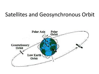
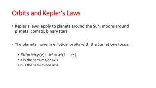
  3. 1.5 Special Types of Inclined Orbits. A satellite orbiting in a plane that coincides with the equatorial plane of the earth is in an EQUATORIAL ORBIT. A satellite orbiting in an inclined orbit with an angle of inclination of 90 degrees or near 90 degrees is in a POLAR ORBIT. As shown in fig 1.8 fig 1.8 1.6 The Elliptic Orbit The only orbit type we will discuss here is the elliptic orbit as shown in fig ( 1.9) . All satellites that orbit around the Earth are in a elliptic orbit. A parabolic and hyperbolic orbit are non-periodic, and hence represent escape orbits, that is, the satellite in these orbits leaves the Earth. The parabolic orbit is the minimum energy escape orbit.

  4. fig 1.9 In the figure we can identify the followingitems: Occupied focus location of the Earth or central attracting body a = semi-major axis r = radius from center of Earth to satellite rp = Earth perigee distance ra = Earth apogee distance e = orbit eccentricity (0<e<1 for elliptic orbits, e = 0 is circular orbit) Note that r is measured from the center of the Earth, hence we can note that: where h = height above Earth s surface, Re = earth radius Often times the perigee and apogee distances are given in terms of the height above the Earth s surface. This is not correct, and the radius of the Earth must be added to the height to get the perigee and apogee radii. The polar equation for the elliptic orbit, with the origin at one focus is given by:

  5. .(1) ... .(2) ..(3) Example The international space station is in a 372 x 381 km orbit , what is the eccentricity of the orbit? Solution: The two numbers refer to the perigee height (372 km) and the apogee height (381 km). However, these are the heights above the Earth s surface and must be converted to perigee and apogee radii by adding the Earth s radius. Hence the international space station is in a near circular orbit. In order to find the apogee and perigee height. The length of the radius vectors at apogee and perigee can be obtained from the geometry of the ellipse:

  6. from equation (2) , Where ra: radius vector at apogee rp: radius vector at perigee e : Eccentricity Then we can calculate haand hpas follow: 1.7 Circular Orbits We stated previously that a circular orbit is a special type of elliptical orbit. It should realize a circular orbit is one in which the major and minor axis distances are equal or approximately equal. Mean height above earth, instead of perigee and apogee, is used in describing a circular orbit. A satellite in a circular orbit at a height of approximately 36000 Km above the earth is in a synchronous orbit. At this altitude the period of rotation of the satellite is 24 hours, the same as the rotation period of the earth. In other words, the orbit of the satellite is in sync with the rotational motion of the earth. Although inclined and polar synchronous orbits are possible, the term synchronous usually refers to a synchronous equatorial orbit. In this type of orbit, satellites appear to hover motionlessly in the sky. Figure 1-8 shows how one of these satellites can provide coverage to almost half the surface of the earth. Figure 1-8 - Illumination from a synchronous satellite.

  7. Three of these satellites can provide coverage over most of the earth (except for the extreme north and south polar regions). A polar projection of the global coverage of a three-satellite system is shown in figure 1-9. Figure 1-9. - Worldwide synchronous satellite system viewed from above the North Pole. 1.8 Kepler's Law: Johann Kepler determined three laws characterizing orbital motion, These laws can be proven mathematically using Newton's law of gravitation. Kepler's laws are paraphrased below along with the corresponding physical implications. These laws apply directly to satellite orbital motion, thus the laws are from the point of view of an Earth-orbiting satellite. Kepler's First Law: Satellite orbits are elliptical Paths with the Earth at one focus of the ellipse Kepler's Second Law: A line between the center of the Earth and the satellite sweeps out equal areas in equal intervals of time.

  8. Kepler's Third Law: The square of the orbital period is proportional to the cube of the the orbit's semi major axis. 9. Elevation angle The angle from the horizontal to the point on the center of the main beam of the antenna when the antenna is pointed directly at the satellite Coverage angle - the measure of the portion of the earth's surface visible to the satellite Reasons affecting minimum elevation angle of earth station s antenna o (>0 ) Buildings, trees, and other terrestrial objects block the line of sight Atmospheric attenuation is greater at low elevation angles Electrical noise generated by the earth's heat near its surface adversely affects reception

  9. Figure 1-10. Elevation angle Orbit Height h CoverageAngle ElevationAngle ?+ ?=???(?+ ?) ? ???(?) Ex : A satellite at a distance of 10000 km from a point on the earths surface , the Coverage Angle = 4 draw and find the Elevation Angle . R= 6378 * ?km 1.10 The ForcesActing on Satellite When a satellite is launched, it is placed in orbit around the Earth. The Earth's gravity holds the satellite in a certain path as it goes around the Earth, and that path is called an "orbit." There are two main forces acting on satellite : a centrifugal force due to the kinetic energy of the satellite, which attempts to fling the satellite into a higher orbit. And a centripetal force due to gravitational attraction of the planet about which satellite is orbiting, which attempts to pull the satellite down forward the planet. If these two forces are equal, the satellite will remain in stable orbit. The formula for centrifugal force is: Fc = (mv2)/r

  10. The formula for the gravitational force between two bodies of mass M and m Fg= (GMm)/r2 is Where M is the mass of the Earth, m is the mass of the satellite G (Newton's Gravitational Constant, r is the orbital radius v the speed of satellite. For the satellite stable in orbit , Fc= Fg, then (mv2/r) = (GMm)/r2 v2/r = (GM)/r2 Now, v = 2 r /T then (2 r/T)^2 /r = GM /r^2 => (4 2 r)/T2 = (GM)/r2 => r3 = (GMT2)/4 2 We know that T is one day, since this is the period of the Earth. This is 8.64 x 10⁴ seconds. We also know that M is the mass of the Earth, which is 6 x 1024 kg. Lastly, we know that G (Newton's Gravitational Constant) is 6.67 x 10- 11 m3/kg.s2 So we can work out r. r3 = 7.57 x 10²² Therefore, r = 4.23 x 107 = 42,300 km. So the orbital radius required for a geostationary, or geosynchronous orbit is 42,300km. Since the radius of the Earth is 6378 km the height of the geostationary

  11. orbit above the Earth's surface is ~36000 km. Fig 1.11 Gravitational force is inversely proportional to the square of the distance between the centers of gravity of the satellite and the planet the satellite is orbiting, in this case the earth. The gravitational force inward (FIN, the centripetal force = Fc) is directed toward the center of gravity of the earth. The kinetic energy of the satellite (FOUT, the centrifugal force= Fg) is directed opposite to the gravitational force. Kinetic energy is proportional to the square of the velocity of the satellite. When these inward and outward forces are balanced, the satellite moves around the earth in a free fall trajectory: the satellite s orbit.

  12. Fig 1.12 The forces acting on satellite 1.11 Orbital Velocity The velocity required to maintain a satellite at the orbit radius r can be calculated as follow:- Depending on the laws of motion first developed by Kepler and Newton. The competing forces act on the satellite; gravity tends to pull the satellite in towards the earth, while its orbital velocity tends to pull the satellite away from the earth, as in 1.13 The gravitational force, Fin, and the angular velocity force, Fout, can be represented as: For the satellite stable in orbit , Fc( Fin ) = Fg (Fo), then (mv2/ =(GMm)/r2 v2/r = (GM)/r2 Where v : satellite velocity for circular orbit in km/sec

  13. Figure 1.13 Forces acting on a satellite Note that for the discussion above all other forces acting on the satellite, such as the gravity forces from the moon, sun, and other bodies, is neglected. Example Human-made satellites typically orbit at heights of 400 miles from the surface of the Earth (about 640 kilometers, or 6.4 105meters). What s the speed of such a satellite?All you have to do is put in the numbers: This converts to about 16,800 miles per hour. 1.12 Launching Satellites into Orbit. Placing a satellite into geosynchronous orbit requires an enormous amount of energy. The launch process can be divided into two phases: the launch phase and the orbit injection phase. The Launch Phase During the launch phase, the launch vehicle places the satellite into the transfer orbit--an eliptical orbit that has at its farthest point from earth (apogee) the

  14. geosynchronous elevation of 22,238 miles and at its nearest point (perigee) an elevation of usually not less than 100 miles as shown below in Figure 1-14. The Orbit Injection Phase The energy required to move the satellite from the elliptical transfer orbit into the geosynchronous orbit is supplied by the satellite s apogee kick motor (AKM). This is known as the orbit injection phase. Figure 1-14: The EllipticalTransfer Orbit Ageostationary orbit is an orbit in which a spacecraft can appear to hover over a fixed point on Earth. That is particularly useful for communication or observation satellites. This is a little different than a geosynchronous orbit, which is one in which a spacecraft will pass over the same point, once per day. So, if we want our spacecraft to appear to hover over a fixed point on Earth, two criteria must be met. The first is that the orbit must be equatorial (inclination of 0 degrees) and the second that the angular velocity must match that of the surface of the Earth. That turns out to be around 35,900 km (22,300 miles). That gives us two challenges to solve. The first is that we need to get to that high

  15. altitude and the second is that we likely need to change our inclination . Figure 1-15 Depending on the mission and launch vehicle, one of two things happens first. The rocket often takes the spacecraft to a parking orbit at an altitude of 180-200 km , this called the parking orbit , but it can sometimes skip the parking orbit and go straight to what is called a geostationary transfer orbit. Parking orbits are often used to test vehicle systems before committing to further action. Figure 1-16

  16. The GeostationaryTransfer Orbit (GTO) is a highly elliptical orbit with a perigee of 180-200 km above the Earth's surface and an apogee of around 35,900 km. The spacecraft has an engine that is called theApogee Kick Motor (AKM). That motor is fired at apogee to circularize the orbit. But it usually is not all done at once. Usually theAKM is used three times. Figure 1-17 Each of these burns has two objectives: 1) increase the perigee of the orbit and 2) decrease the inclination of the orbit. 1.13 SiderealTime Vs SolarTime Sidereal Time: is a time scale that is based on the Earth's rate of rotation measured relative to the fixed stars. Sidereal day = 23h 56 m 04.09053 s Solar Time: is a reckoning of the passage of time based on the Sun's position in the sky. Solar day = 24 h Satellite orbits coordinates are specified in sidereal time rather than in solar time. Solartime, which forms the basis of all global time standards.

  17. The earth rotates once per sidereal day of The earth rotates once per sidereal day of 23 h 56 min 4.09s. Use 23 h 56 min 4.09s. 1.14 Footprint: The area on Earth that the satellite can 'see' (or reach with its antennas) is called the satellite 'footprint'.Asatellite's footprint refers to the area over which the satellite operates: the intersection of a satellite antenna transmission pattern and the surface of the Earth Figure 1-18

More Related Content

giItT1WQy@!-/#giItT1WQy@!-/#giItT1WQy@!-/#giItT1WQy@!-/#giItT1WQy@!-/#giItT1WQy@!-/#giItT1WQy@!-/#giItT1WQy@!-/#