Raster Math: Algebraic Expressions and Map Analysis
A method of treating raster layers as algebraic expressions, using arithmetic operators, mathematical functions, and comparison operators for spatial analysis. Explore examples like calculating the probability of encountering the cascade treefrog in Australia's forests. Learn about common functions, mathematical functions, and comparisons in raster math and map algebra.

Uploaded on Mar 02, 2025 | 0 Views
Download Presentation

Please find below an Image/Link to download the presentation.
The content on the website is provided AS IS for your information and personal use only. It may not be sold, licensed, or shared on other websites without obtaining consent from the author.If you encounter any issues during the download, it is possible that the publisher has removed the file from their server.
You are allowed to download the files provided on this website for personal or commercial use, subject to the condition that they are used lawfully. All files are the property of their respective owners.
The content on the website is provided AS IS for your information and personal use only. It may not be sold, licensed, or shared on other websites without obtaining consent from the author.
E N D
Presentation Transcript
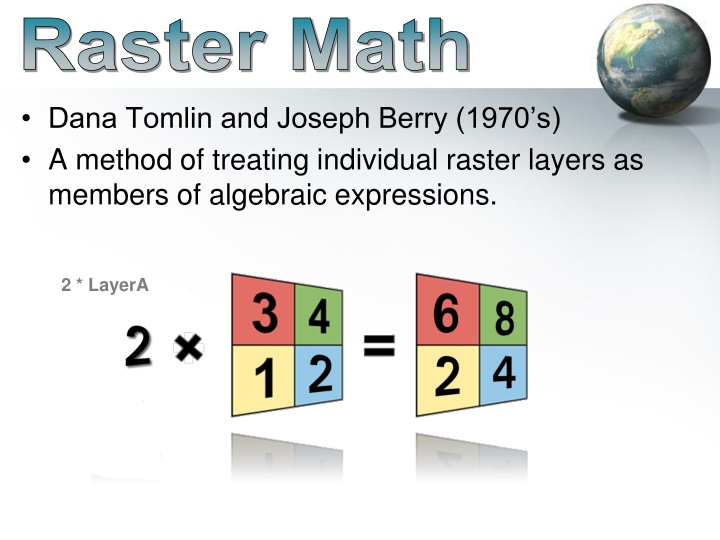
Raster Math Dana Tomlin and Joseph Berry (1970 s) A method of treating individual raster layers as members of algebraic expressions. 2 * LayerA
Raster Analysis Map Algebra Examples: Fire Hazard: [Fuel Density Hazard] + [Slope Hazard] + [Veg Type Hazard] Probability of encountering the cascade treefrog (Litoria pearsoniana) within the forests of eastern Australia: 1 / (1 + exp(10.48 2.204 * log10(RAINFALL) 2.037 * PALMS)) RAINFALL= the annual volume of rain falling in the watershed above the stream PALMS = 1 if palms are present at the site and 0 otherwise.
Raster Math LayerA + LayerB Arithmetic Operators (+, -, *, /) Mathematical Functions (Sqr, Sqrt, Log, Abs, exp, int, etc.) Comparison Operators (>, >=, =, <>, <, <=) Boolean Operators (AND, OR, NOT, XOR)
Raster Calculator Toolbox Spatial Analysis Tools Map Algebra Raster Calculator
Test Yourself 3 2 4 3 0 2 1 9 = -
Analysis Environment Spatial Reference (Coordinate System) Make them the same Extent Area of interest All rasters should overlap Cell Size Largest of all rasters or larger
Raster Math Raster Math Vector or Linear Algebra 1 + 12 = 13 1 2 2 3 12 13 9 10 13 11 = + 15 13
Common Functions Local: Arithmatic: +,-,/, *, MOD (Modulo): returns the remainder Boolean: OR: If either input is true, output is true AND: If both inputs are true, output is true CON (Conditional)
Mathematical Functions Abs (absolute): flips negatives to positive Ceil (ceiling): float to integer next highest integer value (i.e. 1.1 -> 2) Floor: float to integer giving next lowest integer value (i.e. 1.1 -> 1) Int (integer): truncates float to integer
Comparisons <> (Not Equals) == (Equals) < (Less than) <= (Less than or equal to) > (Greater than) >= (Greater than or equal to)
Raster Math: Comparisons 1 > 2 = 0 1 2 2 3 2 3 2 2 0 0 = > 0 1
Raster Math: Boolean AND 0 AND 1 = 0 0 1 0 1 0 0 1 1 0 0 0 1 = AND AND works but the calculator will insert &
Raster Math: Boolean OR 0 OR 1 = 1 0 0 0 1 1 0 1 1 1 0 1 1 = OR OR works but the calculator will insert !