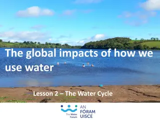
Earth's Water Cycle and Atmospheric Processes


Atmospheric
Circulation
GEO101
Spring 2023

Contents
•
The three states of water
•
The global water balance
•
Humidity
•
Precipitation
•
Atmospheric pressure
•
Winds
•
Global wind and pressure patterns
The three states of water
•
Majority of water occurs as ocean saltwater.
•
Of the remaining water (only 2.8%), the
majority is accounted for by glaciers and ice
sheets, and groundwater.
•
Only 0.001% occurs in the atmosphere.
•
The global water
balance constantly
cycles between
these reservoirs.
•
Note that even
though the
atmosphere
contain
relatively little
water, it is responsible for the largest flow.
How water is stored and moved throughout the Earth system
Humidity
•
Humidity is the amount of water vapor in
the atmosphere.
•
Warm air can hold much more than cold
air.
•
Cold dry air can have close to 0%
•
Warm tropical air may have 4-5%
•
two ways to describe humidity (specific
humidity and relative humidity).
Specific humidity
•
is the actual quantity of water vapor in
the air
•
expressed as grams of water per
kilogram of air (g/kg)
•
Used to describe the water content of
large air masses, and how it varies by
latitude
Specific humidity and temperature
Pole-to-pole
specific
humidity
Relative Humidity
•
compares amount of water vapor
present to the maximum amount that
the air can hold at that temperature (%)
•
E.g. if relative humidity is 50%, it
contains half the amount it could have
given the temperature.
•
Relative humidity therefore changes as
temperature changes.
Relative humidity and temperature
Relative Humidity and temperature
•
e.g. if
temperature
increases, if the
amount of water
vapor stays the
same, then
relative humidity
decreases
Dew Point Temperature
•
If air is cooled eventually it will be said
to be saturated (100% relative humidity)
= (dew point temperature)
•
If cooling continues, condensation
begins and dew forms
Clouds
•
Made up of water droplets and/or ice
particles
•
Form when air is saturated and contains
particles (condensation nuclei) e.g.
dust, salts.
•
Water can remain in liquid state below
freezing (super cooled) to as low as -12
degrees.
Precipitation
For precipitation to occur, it requires:
•
growth of droplets in clouds
•
ice - crystal process - ice particles act
as freezing nuclei
•
coalescence process - large droplets
collide with smaller ones
All precipitation begins as frozen water.
Types of Precipitation:
•
freezing rain
(ice crystals freeze onto a
frozen surface)
•
snow
(ice crystals have not melted)
•
sleet
(ice crystals melt as they fall)
•
hail
(melting and refreezing crystals that
form in thunder clouds)
Orographic precipitation
•
Air rising over a mountain
•
Intercepting slope = Windward slope
(wetter)
•
Leeward slope (drier) (rain shadow)
Convectional Precipitation
•
Warm air rises and
cools to dew point
and clouds form.
•
Latent heat release.
•
adds energy and
increases updraft
•
produces
thunderstorms
Frontal (cyclonic) precipitation
•
where air masses with
different temperatures
come together
•
warm air lifted by cold
dense air along a
weather front
•
leads to frontal
precipitation
Atmospheric Pressure
As the atmosphere is
held down by gravity, it
exerts a force upon
every surface (pressure
= force per unit area).
At sea level the force is
the weight of 1 kg of air
that lies above each
square centimeter of the
surface (around 15 lbs.
per inch)
Atmospheric
pressure
decreases rapidly
with altitude near
the surface.
Therefore, a small
change in elevation
will often produce a
significant change
in air pressure.
weak pressure gradient
The pressure gradient forces act at right angles
to the isobars (90 degrees).
strong pressure
gradient
Differences in air pressure = a pressure gradient
Land and Sea breezes
During the day, air over land heats up and the
sea is relatively cool (sea breeze).
land = low pressure and sea = high pressure
At night air over land cools and the sea is
relatively warm (land breeze).
land = high pressure and sea = low pressure
Air descends.
High pressure (anticyclone)
From above
H
Side View
Surrounding air is
relatively low.
L
H
L
L
Air ascends.
Low pressure (depressions, cyclone)
From above
L
Side View
Surrounding air is
relatively high.
H
L
H
H
low pressure
pressure
geostrophic
gradient force
winds
992
996
1000
1004
1008
1012
1016
1020
high pressure
The planet Earth rotates.
•
In the northern hemisphere air appears to be
deflected to the right.
•
In the southern hemisphere, it deflected to the
left.
•
this deflective force =
Coriolis force
•
because the wind is deflected it now flows
parallel to the isobars =
geostrophic wind
Imagine a turntable
•
When not turning, a ball traces
straight line.
•
When moving, ball traces a
curved line.
Friction forces
•
As wind flows over the surface friction reduces the speed.
•
Friction also changes the direction of the geostrophic wind.
•
The pressure gradient force overpowers the Coriolis effect.
•
As a result, wind flow across the isobars.
Upper
atmosphere
•
at 5-7 km above the
surface
•
influenced only by
pressure gradient
force and Coriolis
force
•
geostrophic winds
that flow parallel to
isobars
General Circulation of the Earth’s
Atmosphere
No Deflection
Deflection
Deflection
Deflection is
least at the
equator and
greatest at the
poles
Northern
Hemisphere
H
H
L
L
Southern
Hemisphere
General Circulation of the Earth’s
Atmosphere
Deflection is
least at the
equator and
greatest at the
poles.
SUN
L
H
H
H
L
l
h
l
LOW
PRESSURE
Warm air rises and flows poleward.
L
So, around the equator
= ITCZ (Inter-Tropical
Convergence) Zone
Variable center is calm
known as the
“Doldrums”.
At around 30
degrees North and
South is the
Subtropical High
because cool air
sinks here.
Subpolar low
pressure
because the
warmer air of
the mid-latitudes
rises as it meets
cold polar air
•
Trade winds are
predictable.
•
Northeast in
Northern hemisphere
•
Southeast in
Southern hemisphere
•
At subtropical high
conditions are calm.
•
known as the
“horse latitudes”
From the subtropical
high to the subpolar low
= “westerlies”
•
Includes variable low
and high pressure
systems
•
At the Polar Front cold
and warm air meet -
storms form.
From the Polar High to
the subpolar low are the
Polar easterlies -
variable
Monsoons
In January high pressure over
the land produces dry winds.
Air is flowing towards the
ITCZ.
In July the position of the
ITCZ moves North.
•
Low pressure over the land
causes winds to flow off the
ocean.
•
This brings heavy rainfall.
Smooth westward
flow of upper air
westerlies
Develop at the polar
front, and form
convoluted waves
eventually pinch off
Primary mechanism
for poleward heat
transfer
Pools of cool air
create areas of low
pressure
Rossby Waves
Jet Streams
•
Narrow bands of
high velocity
•
Form along the
polar front and
above the Hadley
cell in the
subtropics
Explore the intricate workings of Earth's water cycle and atmospheric processes, including the distribution of water across various reservoirs, the significance of humidity in the atmosphere, and the influence of temperature on water vapor content. Gain insights into global wind patterns, pressure systems, and the vital role the atmosphere plays in water circulation. Delve into specific and relative humidity measurements, and discover how water is stored and moved throughout the Earth system.

Download Presentation

Please find below an Image/Link to download the presentation.
The content on the website is provided AS IS for your information and personal use only. It may not be sold, licensed, or shared on other websites without obtaining consent from the author.If you encounter any issues during the download, it is possible that the publisher has removed the file from their server.
You are allowed to download the files provided on this website for personal or commercial use, subject to the condition that they are used lawfully. All files are the property of their respective owners.
The content on the website is provided AS IS for your information and personal use only. It may not be sold, licensed, or shared on other websites without obtaining consent from the author.
E N D
Presentation Transcript
Atmospheric Circulation GEO101 Spring 2023
Contents The three states of water The global water balance Humidity Precipitation Atmospheric pressure Winds Global wind and pressure patterns
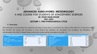
Majority of water occurs as ocean saltwater. Of the remaining water (only 2.8%), the majority is accounted for by glaciers and ice sheets, and groundwater. Only 0.001% occurs in the atmosphere.
The global water balance constantly cycles between these reservoirs. Note that even though the atmosphere contain relatively little water, it is responsible for the largest flow.
Humidity Humidity is the amount of water vapor in the atmosphere. Warm air can hold much more than cold air. Cold dry air can have close to 0% Warm tropical air may have 4-5% two ways to describe humidity (specific humidity and relative humidity).
Specific humidity is the actual quantity of water vapor in the air expressed as grams of water per kilogram of air (g/kg) Used to describe the water content of large air masses, and how it varies by latitude
Pole-to-pole specific humidity
Relative Humidity compares amount of water vapor present to the maximum amount that the air can hold at that temperature (%) E.g. if relative humidity is 50%, it contains half the amount it could have given the temperature. Relative humidity therefore changes as temperature changes.
Relative Humidity and temperature e.g. if temperature increases, if the amount of water vapor stays the same, then relative humidity decreases
Dew Point Temperature If air is cooled eventually it will be said to be saturated (100% relative humidity) = (dew point temperature) If cooling continues, condensation begins and dew forms
Clouds Made up of water droplets and/or ice particles Form when air is saturated and contains particles (condensation nuclei) e.g. dust, salts. Water can remain in liquid state below freezing (super cooled) to as low as -12 degrees.
Precipitation For precipitation to occur, it requires: growth of droplets in clouds ice - crystal process - ice particles act as freezing nuclei coalescence process - large droplets collide with smaller ones All precipitation begins as frozen water.
Types of Precipitation: freezing rain (ice crystals freeze onto a frozen surface) snow (ice crystals have not melted) sleet (ice crystals melt as they fall) hail (melting and refreezing crystals that form in thunder clouds)
Orographic precipitation Air rising over a mountain Intercepting slope = Windward slope (wetter) Leeward slope (drier) (rain shadow)
Convectional Precipitation Warm air rises and cools to dew point and clouds form. Latent heat release. adds energy and increases updraft produces thunderstorms
Frontal (cyclonic) precipitation where air masses with different temperatures come together warm air lifted by cold dense air along a weather front leads to frontal precipitation
Atmospheric Pressure As the atmosphere is held down by gravity, it exerts a force upon every surface (pressure = force per unit area). At sea level the force is the weight of 1 kg of air that lies above each square centimeter of the surface (around 15 lbs. per inch)
Atmospheric pressure decreases rapidly with altitude near the surface. Therefore, a small change in elevation will often produce a significant change in air pressure.
Differences in air pressure = a pressure gradient The pressure gradient forces act at right angles to the isobars (90 degrees). 820 820 830 830 840 850 840 860 870 850 880 890 860 strong pressure gradient weak pressure gradient
Land and Sea breezes During the day, air over land heats up and the sea is relatively cool (sea breeze). land = low pressure and sea = high pressure At night air over land cools and the sea is relatively warm (land breeze). land = high pressure and sea = low pressure
High pressure (anticyclone) Side View From above H H L L L Air descends. Surrounding air is relatively low.
Low pressure (depressions, cyclone) Side View From above L L H H H Air ascends. Surrounding air is relatively high.
low pressure pressure geostrophic gradient force winds 992 996 1000 1004 1008 1012 1016 1020 high pressure
The planet Earth rotates. In the northern hemisphere air appears to be deflected to the right. In the southern hemisphere, it deflected to the left. this deflective force = Coriolis force because the wind is deflected it now flows parallel to the isobars = geostrophic wind
Imagine a turntable When not turning, a ball traces straight line. When moving, ball traces a curved line. Friction forces As wind flows over the surface friction reduces the speed. Friction also changes the direction of the geostrophic wind. The pressure gradient force overpowers the Coriolis effect. As a result, wind flow across the isobars.
Upper atmosphere at 5-7 km above the surface influenced only by pressure gradient force and Coriolis force geostrophic winds that flow parallel to isobars
General Circulation of the Earths Atmosphere Deflection is least at the equator and greatest at the poles Deflection No Deflection Deflection
L H Northern Hemisphere L H Southern Hemisphere
General Circulation of the Earths Atmosphere Deflection is least at the equator and greatest at the poles.
l H h L l H SUN L H
Warm air rises and flows poleward. LOW PRESSURE L So, around the equator = ITCZ (Inter-Tropical Convergence) Zone Variable center is calm known as the Doldrums .
Warmer air rises Cold air sinks HIGH PRESSURE At around 30 degrees North and South is the Subtropical High because cool air sinks here. Subpolar low pressure because the warmer air of the mid-latitudes rises as it meets cold polar air
Trade winds are predictable. Northeast in Northern hemisphere Southeast in Southern hemisphere At subtropical high conditions are calm. known as the horse latitudes
From the subtropical high to the subpolar low = westerlies Includes variable low and high pressure systems At the Polar Front cold and warm air meet - storms form. From the Polar High to the subpolar low are the Polar easterlies - variable
Monsoons In January high pressure over the land produces dry winds. Air is flowing towards the ITCZ. In July the position of the ITCZ moves North. Low pressure over the land causes winds to flow off the ocean. This brings heavy rainfall.
Smooth westward flow of upper air westerlies Rossby Waves Develop at the polar front, and form convoluted waves eventually pinch off Primary mechanism for poleward heat transfer Pools of cool air create areas of low pressure
Jet Streams Narrow bands of high velocity Form along the polar front and above the Hadley cell in the subtropics


 precipitation")


")
")