
Understanding Earth's Interior through Seismic Waves: Part 1
Seismic waves provide crucial evidence about Earth's composition and structure. By analyzing the behavior of primary, secondary, and surface waves, scientists can determine the different layers and materials within the Earth. Primary waves travel through both solid and liquid parts, while secondary
10 views • 10 slides

Improving Heat Rate Efficiency at Illinois Coal-Fired Power Plants
Heat rate improvements at coal-fired power plants in Illinois are crucial for enhancing energy conversion efficiency, reducing carbon intensity, and minimizing pollution. By increasing the heat rate/efficiency by 6%, these plants can generate more electricity while burning the same amount of coal. T
2 views • 11 slides

Alameda Hospital Seismic Planning and Financial Committee Meeting Summary
The Alameda Hospital Seismic Planning and Finance Committee met to review capital cost estimates, consider various seismic options, and assess financial projections. The Joint Planning Committee (JPC) collaborated to evaluate maintaining the current footprint, reconfiguring the hospital, and optimiz
0 views • 23 slides
Enhancing Geotechnical Investigation Methods in Ghana for Foundation Design of Large Structures
Enhancing the standard of geotechnical investigation field testing in Ghana is crucial to ensure appropriate use of equipment like DCP for designing foundations of large structures. Objectives include assessing site suitability, obtaining design inputs, anticipating construction challenges, and esti
0 views • 31 slides
Exploring Subsurface Structures of Pit Craters Through Seismic Reflection
Discover the technique of seismic reflection imaging to unveil the subsurface structures of pit craters on Earth and Mars. Follow the analysis of seismic data to map pit craters and their connections to geological features like dykes and fault jogs, shedding light on the formation processes of these
0 views • 11 slides
Integrated Reservoir Characterization in Semliki Basin, Albertine Graben
Quantitative reservoir characterization using rock physics, seismic, and geological constraints is crucial for hydrocarbon prospect evaluation. This study by Nakajigo Joan explores the integration of these disciplines in the Semliki Basin to improve reservoir property delineation and reduce uncertai
0 views • 24 slides

Understanding Seismic Source Parameters in Earthquake Dynamics
The seismic source parameters in earthquake dynamics involve describing a fault as a discontinuity causing displacements, requiring a complex treatment of forces. The Earth's equilibrium necessitates a specific system of forces to explain displacements along faults. The seismic moment tensor, consis
4 views • 32 slides
Introduction to Data Analysis in Geophysics with Seismic Analysis Code - SAC Lab 2.1
Explore the world of geophysics data analysis using the SAC Lab 2.1 code. Learn about seismic analysis, Fourier transform analysis, spectral analysis, color tracing, integration, differentiation, and more. The SAC online documentation provides valuable resources for users to delve deeper into this f
0 views • 45 slides
Mechanical Isolation Design of Vopo LIGO MIT Lab
The project details the mechanical isolation design for the Vopo LIGO at MIT Lab, covering aspects such as suspension analysis, optical table optimization, and conclusions. It focuses on the seismic isolation of aLIGO, featuring vacuum chambers and CAD models of the suspensions. The concept includes
0 views • 38 slides

Career Path Presentation of Christopher Madugo at Pacific Gas and Electric
Christopher Madugo's career path at Pacific Gas and Electric involves a strong focus on seismic hazard assessment for utility infrastructure. With expertise in fault characterization and geohazard sensitivity, he has contributed significantly to projects like the Panama Canal Expansion. In-house at
0 views • 12 slides
Determining OBS Clock Drift Using Seismic Interferometry
Determining clock errors in Ocean Bottom Seismometers (OBSs) is crucial for accurate seismic data recording. This study presents a method using ambient seismic noise and seismic interferometry to correct clock drift in OBSs. The program developed employs Python/Fortran to analyze seismic data direct
0 views • 10 slides

2022 Street and Utility Improvements Project Overview
The 2022 Street and Utility Improvements Project involves various enhancements in infrastructure, including street improvements, pedestrian facilities, arena drop-off, water system upgrades, and sanitary sewer replacements. The project background covers the planning process, data collection, and con
0 views • 19 slides
Understanding Earthquake Magnitudes and Seismic Measurements
Delve into the fundamentals of engineering seismology and earthquake magnitudes, exploring topics such as fault dimensions, slip distribution, spectral shapes, Richter's observations, and logarithmic scales. Gain insights into how seismic measurements are characterized and understand the significanc
0 views • 69 slides

Understanding Earthquakes and Seismic Waves
This lecture delves into the nature and origin of earthquakes, discussing seismic waves, measurement techniques, effects of earthquakes on various Earth systems, and the relationship between earthquakes and plate tectonics. The content touches on topics like the impact of earthquakes on biosphere, h
0 views • 34 slides

Exploring Home Energy Improvements and Smart Technology for Energy Efficiency
Discover how home improvements and energy technology can significantly reduce energy bills. Join the Smart Home Energy Improvements Workshop in Zero Carbon Rugeley to explore approaches for sustainable energy production and usage at home. Learn about retrofitting, smart energy systems, and meet char
0 views • 20 slides
Understanding Surface Wave Dispersion in Seismic Exploration
Surface wave dispersion, explored by James Crane and Bolu Owolana, plays a crucial role in seismic studies. This phenomenon, involving waves spreading at varying speeds, helps evaluate subsurface characteristics based on wavelength. By studying surface waves, researchers can determine velocity, dens
0 views • 14 slides
Federation of Digital Broad-Band Seismograph Networks: Advancing Global Seismic Monitoring
The Federation of Digital Broad-Band Seismograph Networks (FDSN) was established in 1985 to enhance seismic monitoring capabilities worldwide. FDSN collaborates with national institutions, coordinates new station locations, and promotes standardization of seismic instruments. Despite lacking inter-g
0 views • 21 slides
Federation of Digital Broad-Band Seismograph Networks (FDSN) Overview
FDSN, founded in 1985, coordinates digital broad-band seismic networks globally to enhance seismic monitoring and research. It promotes site selection, data exchange, and instrument standardization, facilitating the installation of seismic stations across various scales to support earthquake studies
0 views • 15 slides

Community Feedback on Proposed Active Travel Improvements in Hill Lane
Community feedback was gathered regarding proposed active travel improvements in Hill Lane, including segregated on-road cycle lanes and new zebra crossing points. The majority of respondents expressed support for the initiatives, citing increased safety, encouragement for more cycling and walking,
0 views • 29 slides
Seismic Site Characterization in Metropolitan Vancouver
The Greater Vancouver area faces high seismic risk due to its population density and critical infrastructure. Ground shaking during large earthquakes depends on various factors including the earthquake source, material properties, and site conditions. Efforts are being made to map seismic hazards, u
0 views • 13 slides
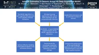
Azimuth Estimation in Seismic Arrays via Deep Augmented MUSIC
This study introduces DA-MUSIC, a hybrid approach combining traditional MUSIC algorithm with deep learning for robust Direction of Arrival (DOA) estimation in seismic arrays. The methodology improves resolution and handles broadband signals effectively. Utilizing non-synthetic seismic data collected
0 views • 4 slides
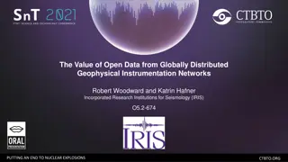
Leveraging Open Data for Global Seismic Discoveries
Geophysicists Woodward and Hafner highlight the transformative power of open data from distributed geophysical networks, emphasizing its role in advancing scientific research, enhancing operational capabilities, and contributing to the mission of ending nuclear explosions. They underscore the value
0 views • 9 slides
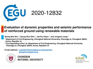
Evaluation of Dynamic Properties and Seismic Performance of Reinforced Ground Using Renewable Materials
Improvement of seismic performance through improved dynamic properties of ground using renewable materials like cement and biopolymer is crucial for reducing earthquake-induced structural damage. This study conducted resonant column tests to assess the enhanced dynamic properties of soil and utilize
0 views • 9 slides
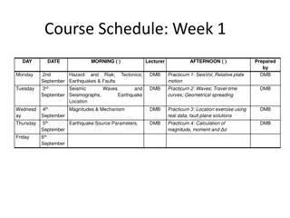
Engineering Seismology & Seismic Hazard Assessment Lectures Overview
This content provides detailed information on the Rose School Lectures 2013 by Sinan Akkar and D. M. Boore focusing on Engineering Seismology & Seismic Hazard Assessment. It includes course schedules, instructor details, contact information, and online software used. Topics covered range from hazard
0 views • 10 slides
Enhanced Algorithm for Internal Multiple Attenuation in Seismic Imaging
This research discusses the development of an improved algorithm for internal multiple attenuation in seismic imaging. The focus is on addressing the challenges in onshore and offshore regions close to a 1-D earth model. The algorithm aims to enhance the efficiency and accuracy of data processing in
0 views • 61 slides
Comprehensive Integration of 4D Seismic & Production Data for Norne Reservoir Management
This presentation by Nan Cheng of Statoil in 2013 focuses on the integration of 4D seismic and production data for reservoir management at the Norne Oil Field in Norway. Covering topics such as field structure, zones, official reserves, production profiles, and subsea development solutions, it provi
0 views • 17 slides

Understanding Earthquakes: Causes, Effects, and Types
Earthquakes are seismic disturbances caused by the release of energy in the Earth's crust. They can lead to significant damage and are classified based on their depth as shallow, medium, or deep earthquakes. This phenomenon includes key elements such as epicenter, focus, hanging wall, footwall, eart
0 views • 7 slides
Earthquake and Hazard Assessment Course Schedule
This course covers a comprehensive study on earthquakes, faults, ground motions, seismic assessments, hazard maps, and more. Week by week lectures, practical sessions, and examinations are planned to provide in-depth knowledge on seismic activities and their impacts.
0 views • 4 slides
Innovative Seismic Software and Services for Geophysics Applications
Celebrating 20 years of providing seismic software, dataloggers, and sensors, this company was founded by the original IRIS PASSCAL programming team. With expertise in micro-seismic monitoring and a focus on wide-band, low-power, and portable solutions, they offer sensors with various specifications
0 views • 5 slides
Insights into Soil Stiffness Degradation Using Seismic Dilatometer Data
This content discusses the analysis of soil stiffness degradation curves using data collected from the Flat Dilatometer and Seismic Dilatometer tests. Researchers Sara Amoroso and Paola Monaco present methods for deriving in situ G- decay curves and evaluating shear strain data in various soil types
0 views • 18 slides
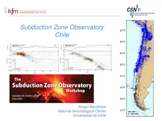
Monitoring Chile's Geological and Volcanic Activity: Subduction Zone Observatory and IPOC Network
Chile's Subduction Zone Observatory, led by Sergio Barrientos at the National Seismological Center, University of Chile, focuses on observing seismic and geological events with cutting-edge technology and networks. The IPOC Chile Volcanological Network monitors around 40 volcanoes, utilizing various
0 views • 4 slides
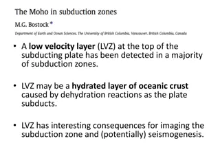
Understanding the Low Velocity Layer (LVZ) in Subduction Zones
The presence of a Low Velocity Layer (LVZ) at the top of subducting plates in subduction zones has significant implications for imaging and potentially seismogenesis. This hydrated layer of oceanic crust, likely caused by dehydration reactions during subduction, affects seismic wave behaviors and ca
0 views • 12 slides
Aging Infrastructure & Seismic Improvements Project Overview
The project application for approval outlines the need for aging infrastructure and seismic improvements, utilizing the GC/CM contracting procedure. The initiative involves funding aspects, project scheduling complexities, team management details, and the rationale behind choosing GC/CM for the proj
0 views • 15 slides
Evaluation of Rock Permeability Variations Using Seismic Velocity Changes
Assessment of fractured rock permeability variations through seismic velocity changes using a coupled simulation of flow, mechanics, and fracture. The study discusses motivation, problem statement, challenges, existing approaches, advantages of the proposed approach, state-of-the-art, mathematical a
0 views • 27 slides
Understanding Fourier Theory in Seismic Processing
Fourier theory plays a crucial role in seismic processing by helping to avoid temporal and spatial aliasing. It emphasizes the importance of sampling rates for accurate waveform reconstruction and highlights the significance of oversampling to prevent aliasing issues. Spatial aliasing is discussed i
0 views • 18 slides
Understanding Earth's Internal Structure: A Geographical Perspective
Deep parts of Earth's interior are studied indirectly through geophysics, including seismic waves, magnetic fields, gravity, and heat. Seismic studies reveal Earth's layers - crust, mantle, and core - each with distinct properties and compositions. The lithosphere, comprising the upper mantle and cr
0 views • 12 slides
Understanding the Structure of the Earth's Interior
Exploring the Earth's interior is challenging due to its vast size and changing composition. Through mining, drilling, and seismic analysis, scientists have gained insights into the layers beneath the surface. Direct and indirect sources provide information on the Earth's structure, including seismi
0 views • 12 slides

Exploring Earth's Interior: Layers, Structure, and Seismic Waves
Explore the dynamic layers of Earth's interior, from its three major layers formed by gravity and chemical segregation to mineral and phase changes in the mantle. Discover how seismic waves provide insights into the planet's composition as they interact with different layers, reflecting and refracti
0 views • 50 slides
Enhancing Disaster Preparedness with Indonesia's Seismic Monitoring Network
Indonesia's Digital Seismic Network, operated by the Indonesian Agency for Meteorology, Climatology, and Geophysics (BMKG), comprises 164 stations strategically located across the country. The network provides critical seismic data for the Seismic Integration System of InaTEWS, supporting real-time
0 views • 11 slides
Reservoir Modeling Using Gaussian Mixture Models
In the field of reservoir modeling, Gaussian mixture models offer a powerful approach to estimating rock properties such as porosity, sand/clay content, and saturations using seismic data. This analytical solution of the Bayesian linear inverse problem provides insights into modeling reservoir prope
0 views • 10 slides