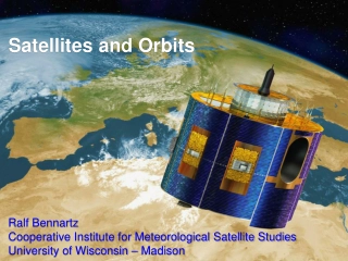
Satellites and Orbits
The realm of satellites and orbits, covering topics such as Kepler's Laws, meteorological satellite orbits, the history of satellite remote sensing, and different types of orbits including geostationary and sun-synchronous orbits. Explore the significance of inclination angles, orbital speeds, and d
3 views • 22 slides
[PDF⚡READ❤ONLINE] Neptune: The Planet, Rings, and Satellites
\"COPY LINK HERE ; https:\/\/getpdf.readbooks.link\/1852332166\n\nRead ebook [PDF] Neptune: The Planet, Rings, and Satellites | Neptune: The Planet, Rings, and Satellites\n\"\n
0 views • 6 slides
Audiobook⚡ Innovative Design, Manufacturing and Testing of Small Satellites (Spr
\"COPY LINK HERE ; https:\/\/getpdf.readbooks.link\/3030091481\n\n$PDF$\/READ\/DOWNLOAD Innovative Design, Manufacturing and Testing of Small Satellites (Springer Praxis Books) | Innovative Design, Manufacturing and Testing of Small Satellites (Springer Praxis Books)\n\"\n
0 views • 6 slides
Initial Composition and Requirements of GBON for Effective Meteorological Monitoring
The 19th World Meteorological Congress established the Global Basic Observing Network (GBON) to enhance meteorological monitoring worldwide. The GBON includes specific resolutions, guidelines, requirements, and compliance criteria for surface land stations, upper air stations, aircraft data, and rem
2 views • 24 slides
Autonomous Conjunction Assessment Methodology Among Satellites
Methodology for Collision Avoidance (CA) among constellations of autonomously-controlled satellites is crucial for protecting assets in space. From straightforward protection against dead satellites to active coordination for maneuverable payloads, the range of primary-secondary CA possibilities is
1 views • 12 slides
Understanding Remote Sensing Sensor Resolutions & Colour Composite
Explore the art and science of remote sensing, detailing sensor types, resolution categories, and color composite techniques. Learn about the stages involved in remote sensing, sensor variations, and band designations for satellites like Landsat 8. Discover the significance of pixel, high-resolution
3 views • 13 slides
Ecosystem for Micro and Small Satellites Based on 3U-ADHA Modules
This presentation discusses the development of an ecosystem for micro and small satellites using 3U-ADHA modules and units. It covers the background, mission criticality classes, small satellite avionics needs, and proposes a standardized modular system for small satellites. The overview includes ex
0 views • 17 slides
A Brief History of Space Exploration
Space exploration has seen significant milestones, from the German V2 rocket in 1942 to Yuri Gagarin becoming the first man in space in 1961 and the historic Apollo 11 moon landing in 1969. Animals like fruit flies and monkeys have ventured into space, contributing to scientific understanding. Russi
2 views • 14 slides
Understanding Satellite Communication: Key Concepts and Applications
Satellite communication is a vital technology that involves relaying signals between different locations on Earth through artificial satellites. This communication system has revolutionized various sectors like telecommunication, weather forecasting, resource monitoring, and more. Learn about the wo
1 views • 10 slides
2021 Meeting of Directors of Meteorological Services - Actions and Updates
The document discusses the status of actions from the previous meeting of the directors of meteorological services in 2021. It includes updates on convening a committee for reviewing proposed courses, resolving operational matters, and implementing various meteorological services. The content also e
0 views • 4 slides
Climate Change Analysis by Japan Meteorological Agency
Tokyo Climate Center, under Japan Meteorological Agency, uses climate models to assess global warming effects. The observed trends in Tokyo show a significant rise in temperature but no discernible trend in precipitation. Future projections indicate a substantial increase in temperature with uncerta
1 views • 6 slides
Exploring Satellite Orbits and Space Missions
This content covers a variety of topics related to satellites, including geosynchronous orbit, satellite history, organisms sent to orbit, types of orbits, orbital altitudes, and current satellite usage. It delves into the history of satellite launches, types of orbits, and the functions of satellit
0 views • 20 slides
Principles of Satellite Communications in Engineering
Explore the history and fundamentals of satellite communications, including the evolution from the first artificial satellite, Sputnik, to modern active and passive satellite systems. Learn about communication via satellites as microwave repeater stations, bridging distances and optimizing frequenci
0 views • 13 slides
Meteorological Forcing Trends and Hindcasts for Climate Research
The content discusses the available meteorological forcing trends analyzed by Bertrand Bessagnet and Augustin Colette from Institut National de L'Environnement Industriel et des Risques. It explores the rationale behind using ECMWF/IFS for recent campaign analyses and the need to find a consistent 1
0 views • 5 slides
Enhancing Safety Measures for Ships during Volcanic Activity
Analyzing the hazards posed by volcanic activity to maritime shipping, this presentation explores the various risks such as physical damage, loss of stability, and impacts on instruments and engines. It discusses sources of information available, including Volcanic Ash Advisory Centers and Volcanic
0 views • 8 slides
Meteorological Data Analysis and Visualization Tools for Regional Weather Services
Explore advanced tools and technologies for analyzing and visualizing meteorological data in regional weather services. From observational variables to forecast and ensemble models, learn about different plotting methods, interactive features, and map layers used in the field of meteorology. Enhance
0 views • 6 slides
Exploring Weather Phenomena and Meteorological Predictions
Dive into the fascinating world of weather phenomena and the science behind meteorological predictions in this unit of Living By Chemistry SECOND EDITION. Learn about proportional relationships, temperature scales, behavior of gases, and how to interpret weather maps to make accurate predictions. En
0 views • 19 slides
Insights on Observation Error, Ensemble Spread, and Radar Reflectivity in Meteorological Analysis
Explore topics such as temporal and spatial variability in observation error, ensemble spread analysis, baseline observations at DWD, estimation of observation errors, and radar reflectivity analysis. Gain insights into data processing and interpretation in meteorological studies.
0 views • 26 slides
Enhancing Societal Benefits: Key Recommendations from OCP-HL-3, June 2022
NMHSs, research, and the private sector are fostering partnerships to enhance societal benefits. Policies, legislation, and sustained funding are crucial for the sound development of meteorological services. NMHSs must evolve, emphasize socioeconomic needs, and establish win-win partnerships. WMO's
0 views • 6 slides
Evolution of Rainfall Monitoring and Meteorological Services in India
The history of rainfall and weather services in India dates back to the early 19th century when the observatory in Madras began recording rainfall in 1793. The India Meteorological Department played a vital role in standardizing rainfall measurements and providing technical guidance to state governm
0 views • 10 slides
Implementation Experiences of CAP by Kenya Meteorological Department
Kenya Meteorological Department (KMD) has been implementing the Common Alerting Protocol (CAP) since late 2012 to enhance the production and dissemination of weather advisories and warnings. KMD is responsible for generating weather alerts, identifying threat events, and classifying messages based o
0 views • 24 slides
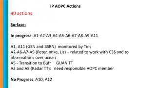
Progress and Actions in Meteorological Data Exchange
International efforts are underway to enhance the exchange of meteorological data, including SYNOP and CLIMAT reports, to improve data archives and analysis. Key actions involve monitoring data receipt, upgrading web systems for data visualization, and providing precipitation data to global centers.
0 views • 14 slides
Innovations in Hydro-Meteorological Observatories for Sustainable Environmental Monitoring
This document showcases various design principles and technologies used in the Trans-African Hydro-Meteorological Observatory project, aiming to enhance data collection in meteorology and hydrology for sustainable land monitoring. Key features include robust, low-cost, and self-calibrating systems t
0 views • 33 slides
Impact-Based Forecasting and Warning Services in Mauritius: Successes and Challenges
The experience of the Mauritius Meteorological Services in implementing Impact-Based Forecasting and Warning Services is detailed, highlighting successes and challenges encountered in November 2016. The article discusses the main weather hazards faced by Mauritius, such as tropical cyclones, heavy r
0 views • 21 slides
CAP Implementation in Cuba: Experiences and Perspectives for Rapid Progress
José Rubiera, Ph.D., discusses the urgent need for implementing the Common Alerting Protocol (CAP) in Cuba to enhance weather watches and warnings. The challenges faced by the Cuban Meteorological Service are explored, along with plans for CAP implementation in 2020. The overview of Cuba's weather
0 views • 37 slides
Informal Conference of South-East Europe Directors on Hydro-Meteorological Services
ICSEED 13th Session in Banja Luka focused on achievements and actions between meetings of Hydro-Meteorological Services in Bosnia and Herzegovina. The conference highlighted the Memorandum of Understanding between different institutions for cooperation in meteorology and hydrology. Through cross-bor
0 views • 23 slides
Satellite System Design Considerations and Applications
Satellite system design involves various technical considerations such as optimal modulation, coding schemes, and service types. Positioning satellites in orbit faces challenges like frequency and orbit selection. Satellite limitations include high initial investments and spectrum crowding. However,
0 views • 32 slides
Understanding Broadband Communication Systems and Satellite Communications
Broadband communication systems involve the use of satellites for various applications such as TV services, data services, and communication with ships and aircraft. This content delves into orbital mechanics, the gravitational forces in satellite orbits, as well as the orbital heights and velocitie
0 views • 57 slides
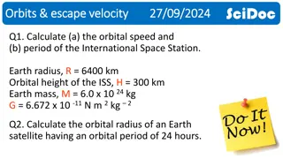
Orbital Mechanics and Satellites Overview
This content provides calculations for the orbital speed and period of the International Space Station, as well as the orbital radius of an Earth satellite with a 24-hour period. It explains the concept of artificial satellites, different types of orbits such as Low Earth Orbit (LEO), Medium Earth O
0 views • 17 slides
Satellite Technology in Meteorological Forecasting
Egbert Quatre, a Forecasting Officer, utilizes satellite technology for weather forecasting. He uses EUMETSAT and Fengyun satellites to analyze cloud features, weather patterns, and extreme events. Challenges include the lack of now-casting tools and the need for more trained forecasters in Satellit
0 views • 8 slides
Analysis of Meteorological Drought in Western Romania: A Case Study of Timisoara Area
Climate changes in Eastern Europe have led to an increase in extreme weather events like droughts in Western Romania. This article focuses on the Standardized Precipitation Index analysis of meteorological drought over the last 50 years in Timisoara. Results indicate a rise in severely dry months du
0 views • 20 slides
Collaboration Opportunities in Meteorology for Islamic Countries
The Ministry of Forestry and Water Affairs in Turkey, along with the Turkish State Meteorological Service, organized a meeting for General Directors of Meteorological Agencies from Islamic countries in May 2017 in Istanbul. The areas of possible cooperation included observations and observing system
0 views • 9 slides
Reconstructing Sea Ice Extent from Early Nimbus Satellites Research
Researchers at the National Snow and Ice Data Center, University of Colorado, are working on reconstructing sea ice extent using data from the 1960s Nimbus series satellites. By digitizing and processing old satellite data, they aim to extend sea ice records back to 1964, potentially adding 16 more
0 views • 16 slides
Unlocking the Potential of Satellites for Improving Life on Earth
Satellites play a crucial role in various aspects of our lives, from enhancing communication and navigation to monitoring weather patterns and protecting tropical forests. They enable connectivity in rural areas, facilitate remote purchases, and support programs like Copernicus by delivering essenti
0 views • 18 slides
Understanding Global Positioning System (GPS) Technology in Satellite Communications
Introduced in the 1970s, the Global Positioning System (GPS) revolutionized location tracking worldwide. Consisting of 24 satellites in the space segment, GPS allows precise positioning on Earth by measuring distances from these satellites. The control segment, including master control stations and
0 views • 7 slides
Monitoring Forest Cover Disturbances During Natural Hazards by Meteorological Satellites
Ecosystem functioning relies on energy, water, and carbon fluxes regulated by vegetation and soil properties. This study focuses on monitoring forest cover disturbances before, during, and after natural hazards using meteorological satellites. It involves analyzing land surface temperature, evapotra
0 views • 37 slides
Satellite Applications in Estimating Earth's Surface Energy Budget
Satellites play a crucial role in estimating the Surface Energy Budget (SEB) by providing data on various components such as Surface Radiation Budget and Surface Turbulent Fluxes. The SEB includes factors like net radiation flux, sensible and latent heat fluxes, and subsurface heat transfer. Satelli
0 views • 38 slides
Evolution of Constituent Bodies in World Meteorological Congress
The evolution of constituent bodies in the World Meteorological Congress from 1951 to 2019 highlights key structural changes, reviews, repeated proposals, and the 2019 governance reform as a significant event. The continuous process of improvement aims to enhance coordination, management, planning,
0 views • 13 slides
Understanding GPS Technology and Augmentations
Global Positioning System (GPS) utilizes a constellation of satellites to accurately determine device locations on Earth. The system consists of 24 satellites orbiting the planet, with an orbital configuration ensuring worldwide coverage. GPS offers high accuracy, with advancements like Differential
0 views • 9 slides
Understanding Satellites: Tracking and Monitoring in Earth Orbit
Exploring the world of satellites, from tracking debris to monitoring Earth's health, this comprehensive resource delves into the crucial role of satellites in modern society. Learn about satellite launches, categorizing purposes, operator countries, and more. Discover how satellites aid in environm
1 views • 5 slides
![[PDF⚡READ❤ONLINE] Neptune: The Planet, Rings, and Satellites](/thumb/21522/pdf-read-online-neptune-the-planet-rings-and-satellites.jpg)


