
Introduction to Enterprise Databases for GIS Professionals
Explore the world of enterprise databases through a GIS perspective with a focus on concurrent clients, database administration, creating databases/tables, checking service names, unique features, numeric data types, data type parameters in ArcGIS, and character data types. Gain insights into managi
0 views • 52 slides

Understanding ArcGIS Network Analyst for Spatial Analysis
ArcGIS Network Analyst offers tools for complex routing problems using a unique network model. Learn about networks, elements, attributes, evaluators, and more to enhance spatial analysis capabilities with ArcGIS.
1 views • 11 slides

Geospatial Technology Services at University of Edinburgh
The University of Edinburgh, through its Information Services, specializes in developing and delivering projects involving geospatial technology. They offer the Digimap Service, providing online access to maps and geospatial data. The university subscribes to the Eduserv Chest Agreement for Esri pro
0 views • 29 slides
Understanding Geodatabases and Creating Them in ArcGIS
Explore the process of creating personal and enterprise geodatabases in ArcGIS for effective spatial planning and GIS applications. Learn step-by-step instructions along with visual aids to create both types of geodatabases.
0 views • 15 slides
Crowd Flow Model Development for Consequence Assessments
Development of a crowd flow model coupled with concentration fields for consequence assessments. The proposed model aims to predict casualty estimates by integrating pedestrian flow and hazardous atmospheric releases. Various existing models like EpiSimS, HPAC, ALOHA, and CATS are considered in the
0 views • 25 slides
Assessment of Water Resource Sustainability in Otter Point, Shirley, and Jordan River
This project focuses on creating a GIS map and central database to evaluate water resource sustainability in Otter Point, Shirley, and Jordan River communities. The objectives include identifying information gaps, barriers to water sustainability, aquifer studies, and assessing the new Water Sustain
0 views • 4 slides
Data Migration Case Study: DevInfo to DSD Using Python, R Scripts, and ArcGIS Online
Explore a case study on migrating data from DevInfo to DSD, involving Python, R scripts, and ArcGIS Online. Learn about the sub-regional workshop in Kigali focusing on data and metadata sharing for English-speaking African countries. Discover the evolution of ChildInfo and DevInfo versions, the upco
0 views • 18 slides

GIS Data Preparation and Joining in ArcGIS
Learn the step-by-step process of preparing and joining data in ArcGIS for mapping projects. From eliminating unnecessary fields in Excel to loading and joining data in GIS, this guide provides detailed instructions to ensure accurate data representation. Exporting the finalized data allows users to
0 views • 9 slides
Advanced Parcel Editing Techniques in ArcGIS
Explore the various tools and functionalities available within ArcGIS for cutting out parcels within a county database without relying on third-party software. Learn about options such as the Cogo Toolbar, Parcel Editor, and Parcel Fabric Toolbar, each offering unique capabilities like parcel splitt
0 views • 19 slides

Transforming Education with Technology: Connecting American Students to Broadband and GIS Resources
In 2013, the White House initiated a program to connect 99% of American students to broadband service, supported by companies like FCC, Sprint, Verizon, Microsoft, Apple, and others. Additionally, Esri is offering $1 billion worth of ArcGIS access for K-12 schools, enhancing students' mapping and da
0 views • 4 slides
Understanding ArcGIS Data Management
Explore the fundamentals of ArcGIS data management, including distinguishing between geodatabase feature classes, raster classes, and associated files, working with layers and visualizations, saving data and map documents, and utilizing MapDocument in Python scripting for data display manipulation.
0 views • 49 slides
Utilizing Distance Data in Statistics: Insights from Denmark
Exploring the essential role of distance data in statistical analysis, this content sheds light on various methods such as pure distance measurements, proximity analysis, and distance calculations between different points like summer cottages and coastal lines in Denmark. From analyzing catchment ar
0 views • 9 slides
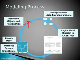
Understanding Data Modeling and Database Schema Design
Explore various aspects of data modeling, ranging from conceptual to physical models, using tools like CASE Tool and ArcGIS. Learn about entity-relationship diagrams, UML notations, and diagrammatic notations in the context of constructing data models. Discover the significance of classes, relations
0 views • 20 slides
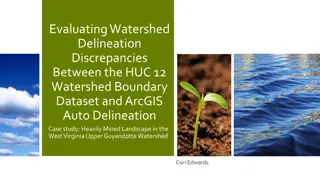
Evaluating Watershed Delineation Discrepancies in West Virginia
This case study explores differences between NRCS Watershed Boundary Dataset and ArcGIS auto delineation in the Upper Guyandotte Watershed in West Virginia. The project aims to quantify discrepancies, analyze landscape characteristics, examine mining impacts, and assess the variations' effects on hy
0 views • 18 slides