Coastlines and Climate Change in Louisiana: A Terrifying Trend
Louisiana has lost nearly 2,000 square miles of coastland in the last 80 years due to human activities and sea level rise. The region faces a grim future with potential disappearance of more land unless major changes are made. Activities such as dam construction, oil exploitation, and invasive species have exacerbated the situation. Global sea level rise is accelerating, with predictions showing a devastating scenario for Louisiana's coastline by 2100. Despite an outlined master plan for coastal restoration, the cost and implementation remain major challenges.

Download Presentation

Please find below an Image/Link to download the presentation.
The content on the website is provided AS IS for your information and personal use only. It may not be sold, licensed, or shared on other websites without obtaining consent from the author. Download presentation by click this link. If you encounter any issues during the download, it is possible that the publisher has removed the file from their server.
E N D
Presentation Transcript
Coastlines and Climate Change Louisiana Example
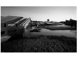
1922 to the present Over the last 80 or more years, Louisiana has lost nearly 2,000 square miles of coastland land that has simply vanished into the Gulf of Mexico. And much, much more land is likely to disappear in the years ahead unless major changes are made. That's the subject of a terrific 2014 investigation from Bob Marshall of The Lens and Brian Jacobs and Al Shaw of ProPublica. You should absolutely go read their entire piece (and check out all of their excellent visuals), but I've made two images of two key maps to highlight the very basic change at play here:
And over the past century, various human activities have disrupted this ecosystem. Great Mississippi Flood of 1927 Army Corps of Engineers built dams, blocking sediment from reaching the delta Discovery of Gulf oil deposits Energy companies dredged thousands of miles of canals through the wetlands to transport equipment through and those canals allowed shoreline to crumble and saltwater to seep in, killing off plants. scientists argue that the land itself has sunk after companies extracted oil and gas from underground wells. The nutria, an invasive rodent species, is also helping destroy the wetlands.
Global sea levels are currently rising 3.2 millimeters per year, on average. But the pace has been much faster in parts of Louisiana, because the activities mentioned above that are causing to land to sink sea levels are rising 9.2 millimeters per year near Grand Isle, La. And if sea level rise accelerates in the decades ahead, as many scientists expect it will, then southeast Louisiana could end up one of the hardest-hit areas. Next is a map by Louisiana State University's Mike Blum showing what the state's coastline could look like in 2100 in the worst-case scenarios:
Now, the scenario in this map isn't inevitable. There's still a range of projections for future sea- level rise this is just one of them, albeit one that dramatically underscores how vulnerable the region is. So is there anything the state can do? Back in 2012, Louisiana policymakers unveiled a master plan for storm protection and coastal restoration that would, among other things, revamp the system of levees and allow controlled flooding to replenish the delta. That could at least help slow the sinking. The hitch: this plan is estimated to cost more than $90 billion in all and is still far from fully funded a study last November by Tulane Law School's Mark Davis estimated that the state was still $71 billion short.
World-Wide Rising sea levels will have an impact on all coastlines around the world, more or less. River delta lands like the Louisiana coastline will be more affected than other areas, particularly where rivers have had dams built along their course like the Mississippi River. Here are a few such rivers: Columbia River Nile River Chang Jiang (Yangtze R.) Parana-Paraguay drainage basin