Advances in Tropical Cyclone Radar Rainfall Estimation
Reviewing past methods and introducing new tools for radar rainfall estimation in tropical cyclones. Discusses advancements in Dual Polarization rainfall estimation and NSSL's National Mosaic & Multi-Sensor Quantitative Precipitation Estimation. Includes insights on reflectivity-to-rainfall relationships, convective storm patterns, and one-hour rainfall accumulation data. Detailed explanations of NSSL's NMQ/Q2 inputs for precipitation type analysis and conceptual models of Vertical Profiles of Reflectivity (VPR) with a Bright Band. This comprehensive presentation was shared at the 65th Interdepartmental Hurricane Conference.

Download Presentation

Please find below an Image/Link to download the presentation.
The content on the website is provided AS IS for your information and personal use only. It may not be sold, licensed, or shared on other websites without obtaining consent from the author. Download presentation by click this link. If you encounter any issues during the download, it is possible that the publisher has removed the file from their server.
E N D
Presentation Transcript
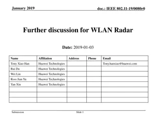
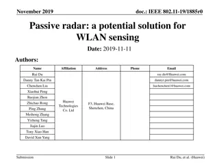
New Tools for Tropical Cyclone Radar Rainfall Estimation Dan Berkowitz Radar Operations Center Norman, Oklahoma 65th Interdepartmental Hurricane Conf. 1
Overview 1. Short review of past methods to convert radar information to rainfall estimates 2. NSSL s National Mosaic & Multi-Sensor Quantitative Precipitation Estimation (NMQ/Q2), New 3. Dual Polarization rainfall estimation, New 65th Interdepartmental Hurricane Conf. 2
1. Past Methods: Reflectivity-to- rainfall (Z-R) relationship Default (Z = 300R1.4) (starting in 1991) Tropical (Z = 250R1.2) (starting in 1997) Hail contamination mitigated by Maximum Precipitation Rate Allowed Corrective gauge-to-radar bias application 65th Interdepartmental Hurricane Conf. 3
Tropical Default convective Tropical Default 65th Interdepartmental Hurricane Conf. 4
Reflectivity & One-Hour Rainfall Accumulation 0.5 OHA 10:57-11:57Z 19 Aug 07 0.5 R 11:57Z 19 Aug 07 65th Interdepartmental Hurricane Conf. 5
Storm Total Rainfall Ending 11:57 UTC 65th Interdepartmental Hurricane Conf. 6
24-hour RFC Rainfall Estimates (using rain gauge adjustment) 65th Interdepartmental Hurricane Conf. 7
2. NSSLs NMQ/Q2 Inputs for Q2 Precipitation Type: Radar reflectivity Base reflectivity for each radar s coverage Vertical Profile of Reflectivity (VPR) Environmental data (updated from RUC) Surface temperature Surface wet bulb temperature 65th Interdepartmental Hurricane Conf. 8
Conceptual Model of a VPR with a Bright Band (Melting Layer) 65th Interdepartmental Hurricane Conf. 9
NSSLs Q2 (continued) Precipitation Types: Convective rain (from VPR) Stratiform rain (from VPR) Tropical rain (from VPR) Hail (from environmental data) Snow (from environmental data) Final Q2 Estimate Adjustments: Quality Control Rain Gauge Data 65th Interdepartmental Hurricane Conf. 10
Q2 Precipitation Types Identified by VPR Convective Tropical Stratiform 65th Interdepartmental Hurricane Conf. 11
(Illustration from http://www.nssl.noaa.gov/projects/q2/tutorial/q2.php ) 65th Interdepartmental Hurricane Conf. 12
24-hour Q2 Rainfall Estimates 65th Interdepartmental Hurricane Conf. 13
3. Dual Polarization 65th Interdepartmental Hurricane Conf. 14
Dual Polarization Overview Oblong drop Spherical drop Hail stone Ice needle 65th Interdepartmental Hurricane Conf. 15
Dual Polarization Variables Differential Reflectivity (ZDR): determines hydro- meteor shape. ^ Z = 10 log ZDR h 10 ^ Z v Values (in dB) >> 0 indicate large (hamburger-shaped) droplets, hail, snow flakes, biological targets, etc.; Values near 0 indicate spherical shapes, such as drizzle, aggregated or granular snow, small hail Values < 0 are usually vertically-oriented ice crystals. 65th Interdepartmental Hurricane Conf. 16
Dual Polarization Variables (cont.) Correlation Coefficient (CC): indicates consistency or similarity of hydro-meteors Values near 1 indicate very uniform targets (e.g., all rain) Values << 1 or near 0 are various types of targets (diverse shapes, orientations, and sizes), such as biological targets, ground clutter, melting snow, etc. Specific Differential Phase (KDP): determines the amount of liquid water causing phase change in radar pulses, particularly the change in phase with distance Heavy rain causes largest values of Kdp. 65th Interdepartmental Hurricane Conf. 17
Quantitative Precipitation Estimate (QPE) Algorithm: High Level Data Flow Data Acquisition Process Base Data (ZDR, KDP, CC, etc.) Hydrometeor Classification Algorithm Melting Layer Detection Algorithm Hydro Class, Mltg Lyr, & DP variables DP variable products plus QPE and other DP algorithm products Environmental data
QPE Algorithm Relationship to Hydrometeor Classification Algorithm Conditions R method (mm/hr) Classification is Ground Clutter or Unknown Not computed Classification is No Echo or Biological 0 Light/Moderate Rain is classified R(Z, ZDR) Heavy Rain or Big Drops are classified R(Z, ZDR) Rain/Hail is classified and echo is below the top of the melting layer R(KDP) Rain/Hail is classified and echo is above the top of the melting layer 0.8*R(Z) Graupel is classified 0.8*R(Z) Wet Snow is classified 0.6*R(Z) Dry Snow is classified and echo is in or below the top of the melting layer R(Z) Dry Snow classified and is echo above the top of the melting layer 2.8*R(Z) Ice Crystals are classified 2.8*R(Z) 65th Interdepartmental Hurricane Conf. 19
Erin - Base Reflectivity 65th Interdepartmental Hurricane Conf. 20
Erin - Hydrometeor Classification Heavy Rain Light or Moderate Rain Biological Big Drops 65th Interdepartmental Hurricane Conf. 21
Erin - Polarimetric Rainfall Rate (DPR) 1-2 in/hr 2-3 in/hr 3-4 in/hr 65th Interdepartmental Hurricane Conf. 22
0.5 degree Reflectivity at 1400Z 65th Interdepartmental Hurricane Conf. 23
Biological Ground Clutter 0.5 degree Hydrometeor Classification at 1434Z Rain Heavy Rain Big Drops Rain-Hail Mixture Unknown 65th Interdepartmental Hurricane Conf. 24
One-Hour Precipi- tation (Legacy Algorithm) at 1400Z 65th Interdepartmental Hurricane Conf. 25
One-Hour Precipi- tation (Dual Pol. Algorithm) at 1400Z 65th Interdepartmental Hurricane Conf. 26
Summary 1. Rainfall estimates originally based on reflectivity alone One Z-R relationship chosen by operator, applied to all reflectivity Maximum rate cap used to mitigate hail contamination Estimate can be adjusted by a rain gauge bias factor 2. NSSL s NMQ/Q2 applies VPR to determine which conversion relationship to use Uses temperature, humidity, and rain gauge data to make adjustments .this is a mosaic product. 3. Dual Pol. QPE algorithm uses classification data from the HCA to determine what relationship to apply for a given radar echo DP data discriminates precipitation from non-precipitation. DP can identify hail, removing most hail contamination. QPE is no longer limited to only one Z-R relationship for all echoes. 65th Interdepartmental Hurricane Conf. 27
References Arndt, D. S., J. B. Basara, R. A. McPherson, B. G. Illston, G. D. McManus, and D. B. Demko, 2009: Observations of the Overland Reintensification of Tropical Storm Erin (2007). Bull.Amer. Meteor. Soc., 90, 1079 1093. Dodson, A., S. Van Cooten, K. Howard, J. Zhang, X. Xu, 2008: Assessing Vertical Profiles of Reflectivity (VPR's) To Detect Extreme Rainfall: Implications for Flash Flood Monitoring and Prediction. Preprints, 22nd Conference on Hydrology- Session 1, Weather To Climate Scale Hydrological Forecasting, New Orleans, LA, USA, AMS, CD-ROM, 1.5. Moser, H., K. Howard, J. Zhang, and S. Vasiloff, 2010: Improving QPE for Tropical Systems with Environmental Moisture Fields and Vertical Profiles of Reflectivity. In Extended Abstract for the 24th Conf. on Hydrology. Amer. Meteor. Soc. Saffle, R. E., M. J. Istok, and G. Cate, 2008: NEXRAD product improvement update 2008. 24th Conference on IIPS, American Meteorological Society Annual Meeting, New Orleans, Louisiana Xu, X., K. Howard, J. Zhang, 2008: An Automated Radar Technique for the Identification of Tropical Precipitation. J. Hydromet., 9, 885-902. Zhang, J., K. Howard, S. Vasiloff, C. Langston, B. Kaney, A. Arthur, S. VanCooten, K. Kelleher, D. Kitzmiller, F. Ding, D.-J. Seo, M. Mullusky, E. Wells, T. Schneider, and C. Dempsey, 2009: National Mosaic and QPE (NMQ) System Description, results and future plans. In Extended Abstract for the 34th Conf. on Radar Meteorology. Amer. Meteor. Soc. Zhang, J., C. Langston, and K. Howard, 2008: Bright Band Identification Based On Vertical Profiles of Reflectivity from the WSR-88D. J. Atmos. Ocean. Tech., 25, 1859- 1872. [ Appendix C (.pdf, 2.0 MB) ] 65th Interdepartmental Hurricane Conf. 28


")


")
 Algorithm:")


")