Vermont Long-Term Soil Monitoring Study Update
Vermont's long-term soil monitoring study aims to detect changes in forest soils due to human-caused impacts like air pollution and climate change. By establishing monitoring sites across different forest types, the study assesses impacts on soil quality, heavy metal deposition, nutrient loss, nitrogen saturation, carbon changes, biodiversity, and water quality degradation over 15 years. The project involves sampling protocols at designated intervals to establish baseline values and archive samples for future comparisons.

Download Presentation

Please find below an Image/Link to download the presentation.
The content on the website is provided AS IS for your information and personal use only. It may not be sold, licensed, or shared on other websites without obtaining consent from the author. Download presentation by click this link. If you encounter any issues during the download, it is possible that the publisher has removed the file from their server.
E N D
Presentation Transcript
Fifteen-Year Update on Vermont Long-term Soil Monitoring Study Thom Villars, USDA NRCS Don Ross, University of Vermont Scott Bailey, USFS Northern Research Station Angie Quintana, USFS GMNF Jim Duncan, VT Forest Ecosystem Monitoring Cooperative Sandy Wilmot, Vermont Dept. of Forest, Parks and Recreation Deane Wang, University of Vermont
Long-term forest soil monitoring Overall goal - detect changes in soils due to (indirect) human-caused impacts (i.e. air pollution, climate change) at two forested sites in Vermont. Monitoring strategy - measure changes in soil properties in forest locations where ecological processes (nutrient cycling, ecosystem development, disturbance) are in a steady state.
Why establish a long-term forest soil monitoring study? What are the impacts of air pollution and climate change on forest soil quality? fate of heavy metals (e.g. mercury and lead) deposited from the atmosphere loss of available nutrients (especially calcium and magnesium) from acid anion-induced leaching Changes in nitrogen status due to nitrogen saturation changes in carbon due to decomposition and/or sequestration loss of biodiversity and forest productivity (growth and mortality rates) degradation of water quality (increases in heavy metal, aluminum and nitrate concentrations, and decreases in pH, base cations and alkalinity). Documentation of temporal patterns in forest soil quality is rare and difficult to obtain due to - confounding effects of spatial variability, and the slow rate of change in soils compared to the time span of typical scientific studies.
Initial Project Goals: 1. Establish five 50 x 50 m relatively uniform plots in sites associated with the VMC. 2. Sample plots at designated intervals: 0, 5, 10, 25, 50, 100, 150, and 200 years (with 2 other times in reserve) Year 0 = 2002 3. Analyze initial samples to determine baseline values. 4. Archive samples for later comparisons. 5. Protect the plots for future monitoring.
5 Monitoring Sites: Mt. Mansfield Ranch Brook northern hardwood Mt. Mansfield Forehead high elevation spruce/fir Mt. Mansfield Underhill State Park transitional forest SCAN site Lye Brook Road northern hardwood SCAN site Lye Brook Trail transitional forest
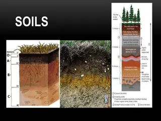
Sampling years have been: Year 0 2002 Year 5 2007 Year 10 2012 Year 15 - 2017 Sampling Protocols for 2007, 2012, 2017: 4 large sample bags collected from each soil pit Oi and Oe combined: Litter layer Oa and/or A: near-surface humified horizons B horizon: Top 10 cm Between 60-70 cm (usually is the C horizon) And small sample bags of each genetic horizon Fourth sampling round of all sites was completed in summer of 2017. No lab data available for these samples yet.
Genetic horizons at each soil pit sampled in smaller bags
Over 1800 soil samples have been collected since 2002 at the 5 study sites. The last three sampling rounds have each generated over 500 unique soil samples. These are used for lab analysis and are archived at UVM. =1855
(Almost) everyone involved in 2017: Sandy Wilmot, Vermont Forests, Parks and Rec Joshua Halman, Vermont Forests, Parks and Rec Isaac Estey, Vermont Forests, Parks and Rec Deane Wang, UVM Don Ross, UVM Emily Piersiak, UVM Liza Lemieux, UVM Jim Duncan, FEMC John Truong, FEMC Matt Gorton, FEMC Scott Bailey, US Forest Service, Northern Research Station Emily Piche, US Forest Service, Northern Research Station (now UVM) Angie Quintana, US Forest Service, GMNF Josh Lobe, US Forest Service, GMNF Thom Villars, NRCS-VT Alexis Clune, NRCS-VT Vermont Youth Conservation Corps (8 crew members) Funding generousy provided by FEMC and Green Mountain and Finger Lakes National Forests
VYCC crew getting digging instructions on 2017 Day One at Ranch Brook site
Scott Bailey, USFS, and Emily Piersiak, UVM, sampling at Forehead site
Angie Quintana-- end of a long day, or thinking about her truck breaking down on Mt Mansfield Toll Road?
Typical site plan with 100 5x5m plots. Plots in yellow have been sampled in 2002-2017 (40 plots to date).
What have we learned in the last 15 years? There is a lot more soil variability than anticipated. Separating trends from natural variation is a challenge. With data from 4th sampling round in 2017, we are just to the point of having enough data to establish baseline levels. Sampling years require a lot of work, a lot of time, a lot of travel, a lot of coordination, and a lot of people. And good luck with the weather. Archiving samples is an ongoing challenge. Sampling intervals needed to be changed to consistent time interval 5 year interval. Length of study shortened from 200 years to 50 years. With precise GPS, we hope to split and re-use each plot up to 4 times, which would add to number of sampling rounds available. Passing the project on to the next generation of scientists is underway. There are unexpected (and perhaps as yet unknown) benefits to the study, as new environmental concerns come to the fore, such as climate change and effects of invasive forest pests like ALB & EAB.
Time period between sampling years revised from increasing yearly interval to constant 5 year interval Change in yearly interval between Sampling rounds 60 50 40 30 20 2027 10 2017 0 1 @ year 0 (2002) 2 @ year 5 (2007) 3 @ year 10 (2012) 4 5 6 7 8 9 10 Initial plan - increasing interval, years Sampling round Currrent plan - 5 year interval
Forehead soil profiles all years FH is only site that has bedrock within depth of study
Carbon in the soil = almost half of all C stored in forest Estimates of carbon stored in Vermont forests, and the annual removal of CO2 from the atmosphere through forest sequestration. Stored Carbon (MMt) Annual accumulation of CO2 (MMt) Vermont forests Soil Forest floor Down dead Understory Standing dead Live trees Wood products Total 139 45.7 12.2 3.2 11.4 172.2 0.7 0.5 0.4 0.03 0.3 6.3 1.4 9.63 383.7
Range in thickness of organic soil layers - Lye Brook Trail vs Ranch Brook FEMC Long-term Soil Monitoring Project LB Trail Plot - thickness of O horizon MM Ranch Brook Plot - thickness of O horizon O horizon Thickness Scale NW NE NW NE 50 m 50 m 91 92 93 94 95 96 97 98 99 100 91 92 93 94 95 96 97 98 99 100 0 - 5 cm 81 82 83 84 85 86 87 88 89 90 81 82 83 84 85 86 87 88 89 90 6 - 10 cm 71 72 73 74 75 76 77 78 79 80 71 72 73 74 75 76 77 78 79 80 11 - 15 cm 61 62 63 64 65 66 67 68 69 70 61 62 63 64 65 66 67 68 69 70 16 - 20 cm 51 52 53 54 55 56 57 58 59 60 51 52 53 54 55 56 57 58 59 60 21 - 25 cm 50 m 50 m 41 42 43 44 45 46 47 48 49 50 41 42 43 44 45 46 47 48 49 50 26 - 35 cm 31 32 33 34 35 36 37 38 39 40 31 32 33 34 35 36 37 38 39 40 21 22 23 24 25 26 27 28 29 30 21 22 23 24 25 26 27 28 29 30 11 12 13 14 15 16 17 18 19 20 11 12 13 14 15 16 17 18 19 20 1 2 3 4 5 6 7 8 9 10 1 2 3 4 5 6 7 8 9 10 SW SE SW SE 5m 5m
Exchangeable Calcium in B horizons (Ranch Brook in class by itself)
New analysis by research institute Climate Central of average wintertime temperatures since 1970 reveals that the U.S. city that s experienced the most warming is Burlington, Vermont, where average winter temperatures have risen 7 F in the last 47 years.
Steering Committee Membership The planning for a long-term soil monitoring study began with a workshop held at the Proctor Maple Research Center in April,1998. From this initial discussion, a working group was formed to move the project forward: Tim Scherbatskoy (UVM) (moved out of state) Nancy Burt (USFS-GMNF) (retired 2013) Deane Wang (UVM) Sandy Wilmot (VT-ANR) Thom Villars (NRCS) Don Ross (UVM) Scott Bailey (USFS-NERS)
In 2017, the FEMC (previously VMC, and VForEM) Vermont Long-term Soil Monitoring Project Steering Team is: Angie Quintana, USFS Green Mountain National Forest Jim Duncan, VT Forest Ecosystem Monitoring Cooperative Deane Wang, University of Vermont (retired June 2017) Sandy Wilmot, Vermont Dept. of Forests, Parks and Recreation (retiring January 2018) Thom Villars, USDA Natural Resources Conservation Service (2022) Don Ross, University of Vermont (2022) Scott Bailey, USFS Northern Research Station (2022)


 everyone involved in 2017:")

 with her co-workers")