Trajectory Data Mining: Overview and Applications


T
r
a
j
e
c
t
o
r
y
D
a
t
a
M
i
n
i
n
g
Dr. Yu Zheng
Lead Researcher, Microsoft Research
Chair Professor at Shanghai Jiao Tong University
Editor-in-Chief of ACM Trans. Intelligent Systems and Technology

Spatial Trajectories
Yu Zheng.
Trajectory Data Mining: An Overview
. ACM Transactions on Intelligent Systems and Technology. 2015, vol. 6, issue 3.
Sources of Trajectory Data
•
Human mobility
–
Active recording
•
Travel logs
•
Sport analysis
•
Check-ins
•
…
–
Passive recording
•
Credit card transactions
•
Public transit records
•
Mobile phone signal, Wi-Fi…
•
….
Yu Zheng.
Trajectory Data Mining: An Overview
. ACM Transactions on Intelligent Systems and Technology. 2015, vol. 6, issue 3.
Sources of Trajectory Data
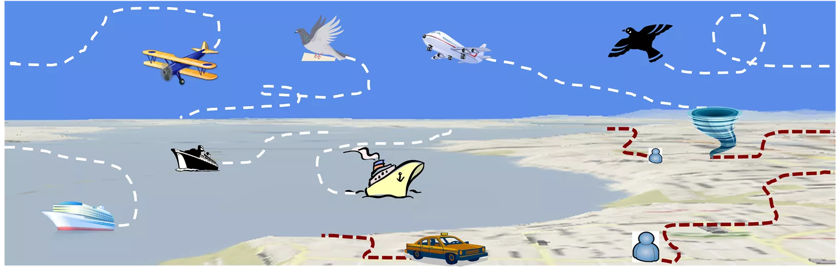
•
Mobility of transportation vehicles
–
Taxis, buses, trucks,…
–
Air planes, ferries, cruise,…
•
Mobility of Animals
–
Migration: Birds, zebra, tiger
•
Mobility of natural phenomena
–
Hurricane, tornado,…
Paradigm of Trajectory Data Mining
Yu Zheng.
Trajectory Data Mining: An Overview
. ACM Transactions on Intelligent Systems and Technology. 2015, vol. 6, issue 3.
Public Trajectory Datasets
•
GeoLife Trajectory Dataset [159]:
–
a GPS trajectory dataset from Microsoft Research GeoLife project [153], collected by 182 users from April 2007 to
August 2012. The dataset has been used to estimate the similarity between users [54], which enables friend and
location recommendations [154][155].
•
T-Drive Taxi Trajectories [160]:
–
A sample of trajectories from Microsoft Research T-Drive project [123], generated by over 10,000 taxicabs in a week
of 2008 in Beijing.
•
GPS Trajectory with Transportation Labels [161]:
–
Each trajectory has a set of transportation mode labels, such as driving, taking a bus, riding a bike and walking.
•
Check-in Data from Location-based Social Networks [162]:
–
The dataset consists of the check-in data generated by over 49,000 users in New York City and 31,000 users in Los
Angeles as well as the social structure of the users. Each check-in includes a venue ID, the category of the venue, a
timestamp, and a user ID.
•
Hurricane trajectories [163]:
–
This dataset is provided by the National Hurricane Service (NHS), containing 1,740 trajectories of Atlantic Hurricanes
(formally defined as tropical cyclone) from 1851 to 2012. NHS also provides annotations of typical hurricane tracks for
each month throughout the annual hurricane season that spans from June to November.
•
The Greek truck trajectories [164]:
–
This dataset contains 1,100 trajectories from 50 different trucks delivering concrete around Athens, Greece. It was
used to evaluate trajectory pattern mining task in [34].
•
Movebank animal tracking data [165]:
–
Movebank is a free, online database of animal tracking data, helping animal tracking researchers to manage, share,
protect, analyze, and archive their data.
Important References
•
Yu Zheng
.
Trajectory Data Mining: An Overview
. ACM Transactions on
Intelligent Systems and Technology, vol. 6, issue 3, 2015.
•
Yu Zheng.
Methodologies for Cross-Domain Data Fusion: An Overview
.
IEEE Transactions on Big Data, vol. 1, no. 1. 2015.
•
Yu Zheng,
Licia Capra, Ouri Wolfson, Hai Yang.
Urban Computing:
concepts, methodologies, and applications
. ACM Transactions on
Intelligent Systems and Technology, vol. 5, issue 3, pp. 38, 2014
•
Yu Zheng
, Xiaofang Zhou.
Computing with Spatial Trajectories
. Springer
2011. ISBN:978-1-4614-1628-9
•
Yu Zheng
, Xing Xie, Wei-Ying Ma,
GeoLife: A Collaborative Social
Networking Service among User, location and trajectory
. IEEE Data
Engineering Bulletin. 33, 2, 2010, pp. 32-40.
Thanks!
Yu Zheng
yuzheng@microsoft.com
Homepage
Yu Zheng.
Trajectory Data Mining: An Overview
.
ACM Transactions on Intelligent Systems and Technology. 2015, vol. 6, issue 3.
A Location trajectory is a geospatial trail generated by a moving object. Typically, this trail is represented by of a set of time-ordered points.
The advance of location-acquisition technologies has boosted the increase of location trajectories, which record the trails of a variety of moving objects, such as people, vehicles, animals and nature phenomena.
These trajectories have not only enabled many applications significantly changing the way we live but also provided us with the scientific observations to understand the objects creating the trajectory.
As a result, the location trajectory has become the foundation a lot of research and attracted intensive attentions from a multitude of areas including computer sciences, biology, sociology, geography, and climatology, etc.
Spatial trajectories represent moving objects in geographical spaces with examples from human mobility, transportation vehicles, animals, and natural phenomena. Sources of trajectory data include human mobility records, active/passive recordings, and sensor data. The paradigm of trajectory data mining covers pattern mining, classification, graph analysis, clustering, privacy preservation, and outlier detection. Public trajectory datasets like GeoLife and T-Drive provide valuable insights for research in this field.

Download Presentation

Please find below an Image/Link to download the presentation.
The content on the website is provided AS IS for your information and personal use only. It may not be sold, licensed, or shared on other websites without obtaining consent from the author. Download presentation by click this link. If you encounter any issues during the download, it is possible that the publisher has removed the file from their server.
E N D
Presentation Transcript
Trajectory Data Mining Dr. Yu Zheng Lead Researcher, Microsoft Research Chair Professor at Shanghai Jiao Tong University Editor-in-Chief of ACM Trans. Intelligent Systems and Technology http://research.microsoft.com/en-us/people/yuzheng/
Spatial Trajectories A spatial trajectory is a trace generated by a moving object in geographical spaces, usually represented by a series of chronologically ordered points, e. g. ?1 ?2 ??, where each point consists of a geospatial coordinate set and a timestamp such as ? = (?,?,?). p4 p3 p5 p2 p6 p12 p1 p7 p10p11 p8p9 Yu Zheng. Trajectory Data Mining: An Overview. ACM Transactions on Intelligent Systems and Technology. 2015, vol. 6, issue 3.
Sources of Trajectory Data Human mobility Active recording Travel logs Sport analysis Check-ins Passive recording Credit card transactions Public transit records Mobile phone signal, Wi-Fi . Yu Zheng. Trajectory Data Mining: An Overview. ACM Transactions on Intelligent Systems and Technology. 2015, vol. 6, issue 3.
Sources of Trajectory Data Mobility of transportation vehicles Taxis, buses, trucks, Air planes, ferries, cruise, Mobility of Animals Migration: Birds, zebra, tiger Mobility of natural phenomena Hurricane, tornado,
Paradigm of Trajectory Data Mining Uncertainty Traj. Pattern Mining Trajectory Classification Graph Mining Moving Together Patterns Clustering Privacy Preserving Freq. Seq. Patterns Trajectory Outlier/Anomaly Detection Periodic Patterns Reducing Uncertainty Routing Trajectory Indexing and Retrieval Distance of Trajectory Matrix Analysis Query Historical Trajectories Managing Recent Trajectories TD MF Trajectory Preprocessing Map-Matching Compression CF Stay Point Detection Noise Filtering Segmentation Matrix Spatial Trajectories Spatial Trajectories Spatial Trajectories Tensor Graph Yu Zheng. Trajectory Data Mining: An Overview. ACM Transactions on Intelligent Systems and Technology. 2015, vol. 6, issue 3.
Public Trajectory Datasets GeoLife Trajectory Dataset [159]: a GPS trajectory dataset from Microsoft Research GeoLife project [153], collected by 182 users from April 2007 to August 2012. The dataset has been used to estimate the similarity between users [54], which enables friend and location recommendations [154][155]. T-Drive Taxi Trajectories [160]: A sample of trajectories from Microsoft Research T-Drive project [123], generated by over 10,000 taxicabs in a week of 2008 in Beijing. GPS Trajectory with Transportation Labels [161]: Each trajectory has a set of transportation mode labels, such as driving, taking a bus, riding a bike and walking. Check-in Data from Location-based Social Networks [162]: The dataset consists of the check-in data generated by over 49,000 users in New York City and 31,000 users in Los Angeles as well as the social structure of the users. Each check-in includes a venue ID, the category of the venue, a timestamp, and a user ID. Hurricane trajectories [163]: This dataset is provided by the National Hurricane Service (NHS), containing 1,740 trajectories of Atlantic Hurricanes (formally defined as tropical cyclone) from 1851 to 2012. NHS also provides annotations of typical hurricane tracks for each month throughout the annual hurricane season that spans from June to November. The Greek truck trajectories [164]: This dataset contains 1,100 trajectories from 50 different trucks delivering concrete around Athens, Greece. It was used to evaluate trajectory pattern mining task in [34]. Movebank animal tracking data [165]: Movebank is a free, online database of animal tracking data, helping animal tracking researchers to manage, share, protect, analyze, and archive their data.
Important References Yu Zheng. Trajectory Data Mining: An Overview. ACM Transactions on Intelligent Systems and Technology, vol. 6, issue 3, 2015. Yu Zheng. Methodologies for Cross-Domain Data Fusion: An Overview. IEEE Transactions on Big Data, vol. 1, no. 1. 2015. Yu Zheng, Licia Capra, Ouri Wolfson, Hai Yang. Urban Computing: concepts, methodologies, and applications. ACM Transactions on Intelligent Systems and Technology, vol. 5, issue 3, pp. 38, 2014 Yu Zheng, Xiaofang Zhou. Computing with Spatial Trajectories. Springer 2011. ISBN:978-1-4614-1628-9 Yu Zheng, Xing Xie, Wei-Ying Ma, GeoLife: A Collaborative Social Networking Service among User, location and trajectory. IEEE Data Engineering Bulletin. 33, 2, 2010, pp. 32-40.
Thanks! Yu Zheng yuzheng@microsoft.com Homepage Yu Zheng. Trajectory Data Mining: An Overview. ACM Transactions on Intelligent Systems and Technology. 2015, vol. 6, issue 3.