Exploring the Tools and Craft of Geography
Discover the essential tools used by geographers, from globes to map projections, as well as the art of determining location through latitude and longitude. Explore the components of maps and geospatial technologies like GPS and GIS, and learn about the geographic perspective and the elements of geography that shape our understanding of the world.

Download Presentation

Please find below an Image/Link to download the presentation.
The content on the website is provided AS IS for your information and personal use only. It may not be sold, licensed, or shared on other websites without obtaining consent from the author. Download presentation by click this link. If you encounter any issues during the download, it is possible that the publisher has removed the file from their server.
E N D
Presentation Transcript
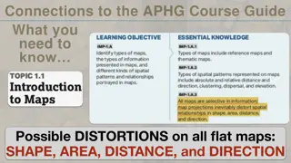
The Geographer's Tools Globes and Map Projections A globe is a scale model of Earth that accurately depicts area, distance, and direction. Cartographers are mapmakers that convert 3-D globe images onto flat maps to create a map projection. There are three types of map projections: planar, cylindrical, and conic.
The Geographers Tools Determining Location Lines of latitude and longitude create a grid system on Earth s surface that is used to determine location. The Equator divides Earth in half, creating the Northern and Southern Hemispheres. The Prime Meridian splits the globe into the Eastern and Western Hemispheres. The absolute location of a place is the point at which its latitude and longitude lines intersect.
The Geographers Tools Using Maps There are many components to a map, including a title, a legend, symbols, and color-coding. Scale represents the consistent, proportional relationship between the measurements shown on a map and on Earth s surface. Physical, political, and thematic maps each serve a unique purpose and show different types of information. A mental map describes an individual s perception of features of Earth s surface.
The Geographers Tools Geospatial Technologies Geospatial technologies include global positioning systems (GPS), geographic information systems (GIS), and remote sensing from satellites and aircraft. GPS uses networks of satellites and receivers to provide the absolute location of something on Earth. GIS are software programs used to process and organize data that links a location to its characteristics. Remote sensing is any technique used to measure, observe, or monitor something without touching it.
The Geographers Craft A Geographic Perspective Geographers study the locations and relationships of Earth s physical and living features. Spatial perspective focuses on how individual places, objects, and people are related to one another across Earth s surface. Thinking like a geographer involves asking and answering geographic questions by acquiring, organizing, and analyzing geographic information.
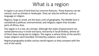
The Geographers Craft The Elements of Geography The six elements of geography include: the world in spatial terms, places and regions, physical systems, human systems, environment and society, and the uses of geography. Geographers group places with similar characteristics into three types of regions: a formal region, a functional region, or a perceptional region. A place has both physical and human significance. Geographers divide their focus into two branches: physical geography and human geography.
The Geographers Craft Research Methods Geographers gather and analyze information through direct observation and measurement, by visiting a place, or through remote sensing. They often convey their findings through mapping. Interviewing involves a geographer asking direct questions to gather information. Technology is often used to help geographers analyze statistics and data and compile findings in an understandable manner.
The Geographers Craft Geography and Other Subjects Geography is used to understand historical patterns, economies, politics, and the impact of societies and cultures on the landscape. Cultural geographers use sociology and anthropology to study human tendencies and past cultures and their influence on current traditions and social norms. Geographers study economies to understand how locations of resources impacts the ways people make, transport, and use goods and services.