Explore Pocket Creek & Meadows Creek Nordic Club Day Tour
Join the popular Mount Hood tour to Pocket Creek & Meadows Creek with stunning scenery and intermediate-level skiing. Carpool from Gateway, departure at 8 AM, no dogs allowed. The tour covers 5.9 miles with a mix of road and trail skiing, with estimated timings and meetup details provided. Cancellations are rare. Contact Scott Diamond for more information.

Download Presentation

Please find below an Image/Link to download the presentation.
The content on the website is provided AS IS for your information and personal use only. It may not be sold, licensed, or shared on other websites without obtaining consent from the author. Download presentation by click this link. If you encounter any issues during the download, it is possible that the publisher has removed the file from their server.
E N D
Presentation Transcript
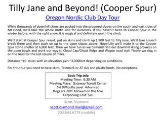
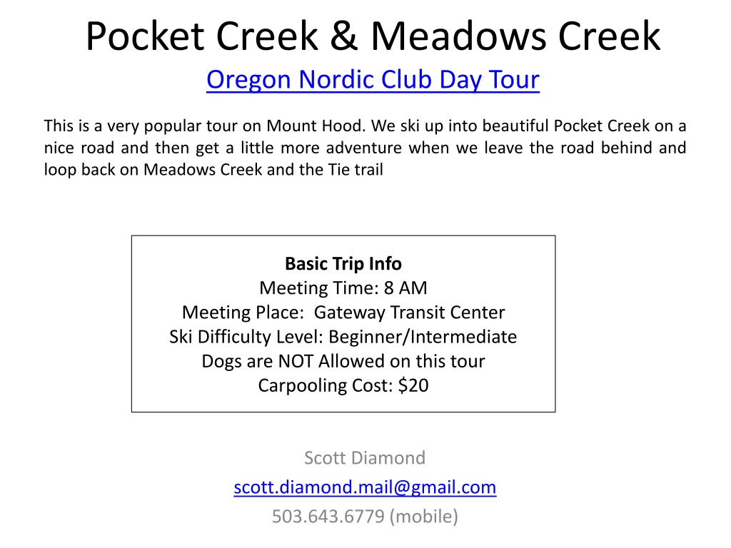
Pocket Creek & Meadows Creek Oregon Nordic Club Day Tour This is a very popular tour on Mount Hood. We ski up into beautiful Pocket Creek on a nice road and then get a little more adventure when we leave the road behind and loop back on Meadows Creek and the Tie trail Basic Trip Info Meeting Time: 8 AM Meeting Place: Gateway Transit Center Ski Difficulty Level: Beginner/Intermediate Dogs are NOT Allowed on this tour Carpooling Cost: $20 Scott Diamond scott.diamond.mail@gmail.com 503.643.6779 (mobile)
Cancellation Cancellations are rare but they do occasionally happen Please check your e-mail before driving out to carpool spot. I ll e-mail only if there is a cancel or change in plans, otherwise the trip is on.
More Detailed Route Info Distance 5.9 miles This is an intermediate ski (but on the easier side of intermediate). The first half of this tour is on Pocket Creek road Straightforward but some work as we climb For the second half, we leave roads behind an ski on trails There are some narrow sections, ups and downs and bridge crossing. This section take intermediate level balance and control.
Difficulty Rating Scale 5 5 5 4 4 4 3 3 3 2 2 2 1 1 1 0 0 0 Technical Skiing Ability Skiing Fitness Isolation/Risk
Estimated Timing 8:00 AM Departure from Gateway 10:15 AM Park at Pocket Creek Sno Park 10:30 AM Start Skiing 4:00 PM Finish Skiing 6:15 PM back at Gateway Note that if you need to rent skis you ll need to rent them prior to the trip. It takes quite a while to rent and it doesn t work to split the group and try and regroup when renting on the way
Tour Starting Point We carpool from Gateway but we start skiing from Pocket Creek Sno Park
Turn around Heading back on trail River Crossing
GPS Map Link Pocket Creek GPS File/Map I like to use the site GPSies to store track. It is a free site and they have apps for mobile devices. Better yet you can export the GPX file to your GPS or favorite GPS Software Numerous smartphone GPS apps are available, my own favorite is Gaia ($20). Sample screen shot for Gaia iPhone Software
ONC Carpooling Policy If we don t have drivers we don t have a trip. If you have a snow compatible car then please drive. If we don t have enough drivers then we ll do a lottery to see who goes. For passengers, the ONC policy is each passenger contributes 15 cents per mile. For three or more passengers, the maximum total contribution by all passengers is limited to 45 cents per mile. A typical round trip distance to Mt Hood and back is 120 miles to 160 miles = $18-$24/person
Maps There are always new trails being developed and the maps I have images for are not the most recent. Therefore, please consider these maps to be a rough guide at best. If you want to buy your own maps for this trip then the best one I ve found for Mt. Hood is the 2015 Mt. Hood Winter Trails (BuyBetterMaps, Amazon or your local REI) The best overall reference books is still Klindt Vielbig s. This is out of print but you can still find used copies on Amazon
ONC Ski Rating Novice level These tours are for the inexperienced skiers. While this is not a lesson, the leader will help new skiers as much as possible. Tour length is 3-5 miles over nearly flat terrain. Beginning/Easy level 4 to 6 Miles over gentle terrain at a pace comfortable for all participants Intermediate level 6 to 12 miles. Terrain flat to long hills that are no steeper than found on a road (maximum 10 degrees). Moderate pace. Trail turning skills required, if there are hills. Advanced level > 12 miles. Terrain flat to steep hills (> 10 degrees). Moderate to fast pace. Strong turning skills required on the tours with steeper slopes.
What to Bring/Gear (click links below for more info) Ski Rental Options What to Wear Tour Essentials Note that if you need to rent skis you ll need to rent them prior to the trip. It takes quite a while to rent and it doesn t work to split the group and try and regroup when renting on the way
Weather Reports Obviously the tour gets cancelled if we don t have enough snow. Additionally if it looks like it is just going to rain on us all day then we ll cancel. I like to use the following site to check the weather. National Weather Service Zone Forecast. Good general description and snow level info. Mount Hood WebCams. Amar Andalkar does a great job at pulling together all the WebCams. For day tours I like to look to see how much snow there is in Government Camp Northwest Avalanche Center Not applicable to the vast majority of ONC tours