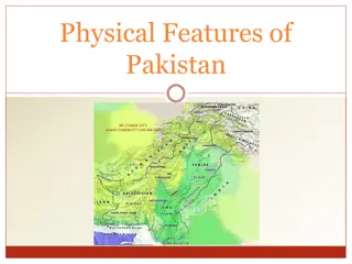
Physiography and Physical Regions of Pakistan
Pakistan's physiography spans diverse physical regions, including mountains, plains, plateaus, and deserts. The country is bordered by China, India, Afghanistan, Iran, and the Arabian Sea. Key mountain ranges include the Himalayas, Karakoram Mountains, and the Hindu Kush. Pakistan's total area is 796,096 sq. km, making it the 36th largest country in the world. The Himalayas feature three parallel ranges: the Sub Himalayas, Lesser Himalayas, and Great Himalayas, with peaks like Nanga Parbat. The Karakoram Mountains host the world's second-highest peak, K2. The Hindu Kush forms the country's northwestern boundary.

Download Presentation

Please find below an Image/Link to download the presentation.
The content on the website is provided AS IS for your information and personal use only. It may not be sold, licensed, or shared on other websites without obtaining consent from the author. Download presentation by click this link. If you encounter any issues during the download, it is possible that the publisher has removed the file from their server.
E N D
Presentation Transcript
Pakistan Physiography or Physical regions Pakistan lies from 23.5 degree to 37 degree north latitude and 61 to 77 degree east longitude. On the north of Pakistan lie china on the east India on the North West Afghanistan on the south west by Iran and on the south by Arabian Sea.
North East North West South west South China India Afghanistan Iran Arabian Sea 585 km 1610 km 2250 km 850 km 700km
The total area of Pakistan is 796,096 sq, km make at the 36 largest country of the world area wise. Pakistan can be divided in to the following Physical division. Regions Mountains area 2, Plains 3 Plateau 4 Deserts Mountains area The mountain of Pakistan is divided in to the following branches North eastern Mountains Mountain in the north North western mountain Western mountain
North Eastern Mountains In the north east of Pakistan lies the Himalayas mountain. The west branches or parts of Himalayas fall in Pakistan,The average height of the Himalayas in Pakistan is 6000 meters. I Pakistan the Himalayas are represented by the 3 parallel ranges. Sub Himalayas or siwaliks. These are of low latitude hills attain height from 600 to 1200 meters. The mountains located in Rawalpindi district are the examples of these mountains. Lesser Himalayas. These mountains rise to an height from 1800 to 4600 meters. These lie to the north of Sub Himalayas. These Mountains cover the area of Batagram, Mansehra, and Abbottabad. Some of the beautiful hill station like Muree, Nithiagali is situated in these mountains.
Great Himalayas. The average height of these mountains is 6000 meters. Nanga Parbat (8126 metres) the 2ndhighest peak in Pakistan (in 6 in the world) are situated in these mountains. The beautiful lake Safiul Muluk in Kaghan valley are lay in these mountains. The peak are cover by the snow almost throughout the year, The Glaciers Rupal (S) 17,6 km long and Rupal (N) 16km long are the main Glaciers in these mountains. Mountain in the North In the north of Pakistan lie the Korakorams Mountains. These mountains work as a boundary between Pakistan and china. It expending from Tibet in the east to the Hindu Kush in west. These mountains are about 200 km wide. There are 20 peaks with more than 7000 meters height are found in Korakorams mountains. K2 the 2ndhighest peak in the world (8611 meters) are found in the Korakorams Mountains. There are 18 Glaciers region found in the Korakorams Mountains. Siachen glaciers also lie in the Korakorams Mountains
North Western Mountains These mountains lie toward the west of Karakoram mountains. The north western Mountains are divided into the following ranges. Hindu Kush. These mountains make the north western boundary of Pakistan. These extended west ward into Afghanistan. The average height of these mountains is 3600 meters. Tirich Mir is the highest peak in this mountain having a height of 7690 meters. Baroghali pass are located in these mountain.
Kohistan, Dir and Swat Mountains. South of Hindu kush lie three parallel mountain ranges which are run from north to south direction called Kohistan, Dir and Swat Mountains. The Mountain lie between river indus and river swat are called kohistan Mountain.The Mountain lie between river swat and river panjkora are called Swat Mountain.The Mountain lie between river panjkora and river kunar are called Dir Mountain. In the north these 3 mountain ranges rise to an height from 5000 to 6000 meter while toward the south the rise as low as 200 meters.
Western Mountain Western Mountain Koh Safed Mountain. The Safid Mountain Range lying south of the K bul River and forming a border with Afghanistan, its average height is 3600 meter. The famous Khyber Pass lie in the Koh Safed Mountain. The Peshawar, Kohat and Bannu vale are covered by these mountains ranges. South of the Safid Range are the hills of Waziristan, which are crossed by the Kurram and Tochi rivers, Sulaiman Kirthar Mountains. These Mountain lie South of Gomel River. It is bounded by Baluchistan plateau from the west and river Indus from the east.the average height of these mountains are 600 meters. Takht-e- Suleiman is the highest peak having a height of 3487 meters. These mountains join the Kirthar mountain in the south. Kirthar Mountains. The Kirthar Mountain separate the Balochistan plateau from the Indus plain Thse mountain are 400 km long and 30 km wide and its run southward to Arabian Sea.
Indus plains Indus plains The name Indus comes from the Sanskrit word sindhu, meaning ocean, The Indus plain have been formed by the alluvium laid down from river Indus and its tributaries. The length of river Indus are 2900 km .the Indus plain can be divided it to the following 2 parts. Upper Indus Plain Lower Indus Plain The Upper Indus plain. It covers most of the Punjab province. The area from Attack to Mithan Kot is called the Upper Indus Plain. In this part a large number of tributaries join the Indus River. The area which is lie between two rivers is called Doab. These Doabs are very fertile soil. The upper Indus Plain can be divided to the following Doab. Bari Doab the area between rive Beas and river Ravi Rachna Doab the area between river Ravi and river Chenab Chaj Doab the area between river Chenab and river Jhelum Sindh Sagar Doab the area between river Indus and river Jhelum
Indus plain Lower The area of lower Indus plain started from Mithan Kot. It cover most of the Sindh province. The soil is very fertile. From Thatta the delta of River Indus started. The area is famous for mangroves forest
The Plateaus The Plateaus The Potwar Plateau The Baluchistan Plateau The Potwar Plateau The Potwar Plateau & the Salt Range located between River Indus & River Jhelum Height 300 to 600 meters from sea level. Soan River is Main River. It forms gullies and large alluvial plains, mainly used for agriculture. Rich in minerals like rock salt, gypsum, lime stone, coal, marble, clays, dolomite & soapstone and oil. While average height of Salt range is 750 to 900m. Sakesar Peak is the highest point in the Salt Range at a height of 1527m. The Baluchistan Plateau The Baluchistan Plateau located in Southwest of Pakistan. This is an extensive area of 347,190 sq. km with a number of distinct natural topographical and drainage features. Average height is about 300 600 meters. Very rich in mineral resources. Scanty Rain fall. Inland drainage. The Kirthar Mountains separate it from Indus plain.
Desert Desert Cholistan Desert The Cholistan desert covers an area of 16,000 square kilometers. The name "Cholistan" is derived from the Turkish word "chol" meaning "desert" though the desert is locally known as the Rohi. The desert hosts an annual jeep rally, many tourists. It covering the districts of Bahawalpur, Rahimyar Khan and Bahawalnagar. etc Thal Desert The Thal Desert is located in Mianwali region of Pakistan between the Indus and Jhelum rivers. A large canal-building project is currently underway to irrigate the land. Irrigation will make most of the desert suitable for farming. Thar Desert The Thar Desert spans an area of 200,000 square kilometers and covers large areas of both Pakistan and India. It is the seventh largest desert on the planet and the third largest in Asia falls under the territory of Sind province,