Operational Ocean Modeling and Forecasting Systems
This content provides an overview of various operational ocean modeling and forecasting systems, including data assimilation processes, glider data, surface and subsurface data sources, forecasting models for hurricanes, and NOAA's hurricane forecasting models. It covers a range of technologies and models used in understanding and predicting ocean behavior for improved operational purposes.

Download Presentation

Please find below an Image/Link to download the presentation.
The content on the website is provided AS IS for your information and personal use only. It may not be sold, licensed, or shared on other websites without obtaining consent from the author. Download presentation by click this link. If you encounter any issues during the download, it is possible that the publisher has removed the file from their server.
E N D
Presentation Transcript
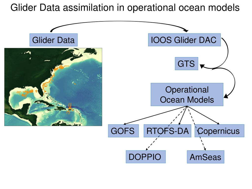
Glider Data assimilation in operational ocean models IOOS Glider DAC Glider Data GTS Operational Ocean Models RTOFS-DA Copernicus GOFS DOPPIO AmSeas
Global Ocean Forecasting System (GOFS) Navy Coupled Ocean Data Assimilation System (NCODA) Surface Data Subsurface Temperature and Salinity Satellite SST Drifting buoys Fixed buoys Argo Floats GOFS/NCODA In Situ SST Gliders TESAC XBTs (only temp.) Satellite Altimeter
Forecasting Model: HWRF-HYCOM System Hurricane Coupled Ocean-Atmosphere IC IC Kim et al. 2014 GOFS/NCODA RTOFS Real Time Ocean Forecasting System GFS Global Forecasting System
Hurricane Coupled Ocean-Atmosphere Forecasting Model: HWRF-HYCOM System RTOFS/DA IC IC Kim et al. 2014 GOFS/NCODA RTOFS Real Time Ocean Forecasting System GFS Global Forecasting System
Forecasting Model: HWRF-HYCOM System Hurricane Coupled Ocean-Atmosphere IC IC Kim et al. 2014 GOFS/NCODA RTOFS Real Time Ocean Forecasting System GFS Global Forecasting System
NOAA Hurricane Forecasting Models HWRF/HYCOM HMON/HYCOM HWRF/POM North Atlantic East Pacific Central Pacific West Pacific North Indian South Indian South Pacific HWRF Hurricane Weather Research Forecasting Model HYCOM Hybrid Coordinate Ocean Model HMON - Hurricanes in a Multi-scale Ocean-coupled Non- hydrostatic model POM Princeton Ocean Model
NOAA Hurricane Forecasting Models HMON/HYCOM HWRF/POM HWRF/HYCOM West/South Pacific, South/North Indian Ocean North Atlantic, East/Central Pacific North Atlantic East/Central Pacific IC come from climatology and the POM (w/ feature model only in the GoM) IC from Global RTOFS nowcast IC and BC from Global RTOFS spun up from the global GOFS 3.1/NCODA
Time of NCODA increments ? FGAT: First Guess at Appropriate Time
Work Flow HMON/HYCOM and HWRF/HYCOM Global GOFS 3.1/NCODA System Nowcast 12Z 7-day frcst 0Z 0Z Nowcast 1-day frcst 0Z 7-day frcst 0Z 0Z 12Z 0Z 12Z 0Z Nowcast 1-day frcst 2-day frcst 0Z 12Z 0Z 0Z 0Z 7-day frcst 0Z 0Z Global RTOFS NCODA Incremental Insertion Window
Hurricane Michael Increments Insertion Window Increments Insertion Window Insertion Window Increments The assimilation of glider data days ahead of Michael corrected the position of the thermocline
From John Wilkin Basic 4D-Var procedure new solution with modified initial conditions xb = model state (background) at end of previous cycle, and 1st guess for the next forecast model-data misfit xb previous forecast observations xb(0)+ x In 4D-Var assimilation the adjoint gives the sensitivity of the initial conditions to mis- match between model and data dxi dt -N(xi)-Fi= 0 0 1 2 3 4 time Observations minus previous forecast (weighted) dimO-1(Hxm-ym) A descent algorithm uses this sensitivity to iteratively update the initial conditions, xa=xb(0)+dx(analysis), to minimize J = Jo+ Jb T -dli dt N x li=dimHTO-1(Hxm- ym) - Adjoint model integration is forced by the model- data error l(0) 12
The best fit becomes the analysis assimilation window xa(tf) xa(ti) ti = analysis initial time tf = analysis final time The strong constraint requires the trajectory satisfies the physics in ROMS. The Adjoint enforces the consistency among state variables.
The best fit becomes the analysis The final analysis becomes initial conditions for the forecast assimilation window forecast ti = analysis initial time tf = analysis final time The strong constraint requires the trajectory satisfies the physics in ROMS. The Adjoint enforces the consistency among state variables.
The best fit becomes the analysis The final analysis becomes initial conditions for the forecast Forecast verification can be w.r.t. data not yet assimilated assimilation window forecast verification ti = analysis initial time tf = analysis final time The strong constraint requires the trajectory satisfies the physics in ROMS. The Adjoint enforces the consistency among state variables.
Data pre-processing flow for MARACOOS ROMS 4DVar Scripts run daily (cron jobs) and use Matlab, Python, perl and NCO tools All times New York local (U.S. EST) From 4D-Var workshop Aug. 2019, John Wilkin

")