CRG.BoG Main Topics: Observations & Consistency in Climate Studies
This document discusses observations, data continuity, validation methods, and consistency in climate studies. It touches on using available instruments, addressing data gap issues, lack of ground-based observations, and ensuring consistency between different Essential Climate Variables (ECVs). Various CCI teams are represented, sharing insights on their approaches and challenges in data collection and analysis.

Download Presentation

Please find below an Image/Link to download the presentation.
The content on the website is provided AS IS for your information and personal use only. It may not be sold, licensed, or shared on other websites without obtaining consent from the author. Download presentation by click this link. If you encounter any issues during the download, it is possible that the publisher has removed the file from their server.
E N D
Presentation Transcript
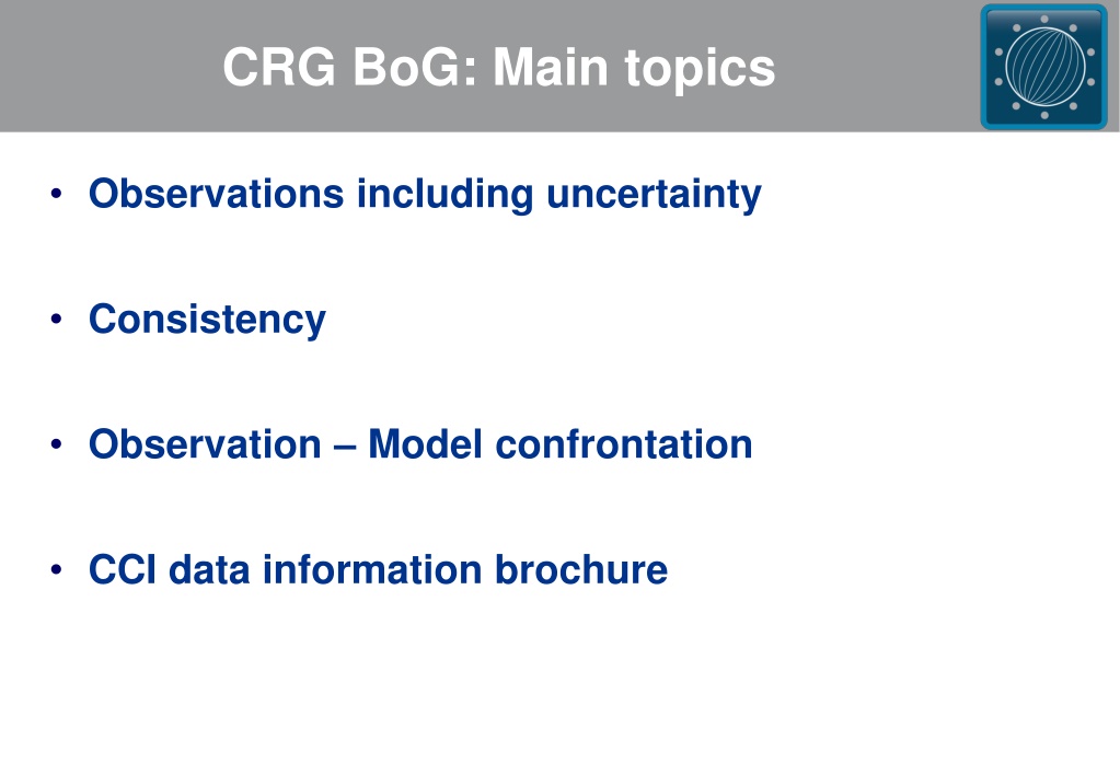
CRG BoG: Main topics Observations including uncertainty Consistency Observation Model confrontation CCI data information brochure
Attendance Represented CCI teams (besides CMUG): SSH SST Cloud GHG O3 Fire LC SI Aerosol ESA: Claus Zenher, Cat Downey (first part only) Guests: M. Roberts (MetOffice, PRIMAVERA)
Observations (1): Data continuity and data temporal coverage: Q: Is your team making use of all available observations/instruments? Could you extend your temporal coverage with additional instruments? GHG: all available satellites considered but focus on those with sensitivity down to surface O3: all European sensors are used SI: all available observations Aerosols: could use high temporal frequency data Q: Do you have data gap issues? If so, how do you tackle or plan to tackle them? GHG: No gaps but potential problems with different data sampling O3: some issues in some cases (limb). Also for MIPAS they have a problem with different spectral resolution that they are trying to address scientifically. SI: long gap in high res data (>1yr) but have low res data EMSValTool: gaps no problem but lack of consistency (e.g. change in algorithm) is
Observations (2): Lack of ground-based observations for validation, also an opportunity for remote sensing Q: Do you have this problem? Are your ground based observations part of a coordinated network (e.g. WOUDC/SHADOZ/NDACC O3; TCCON GHG, Aeronet AOD )? GHG: Only few stations are available and they are also used for Bias Correction Cloud: Cloud profiles, lwc, iwc are available through CloudNet/ACTRIS/ARM. These sites need to be supported on long-term SI: there are ground measurements of thickness but not in a coordinated network. LC: CarbNet provides land-atmosphere carbon flux SST: long time-series mooring Q: Do you use other satellite data for validation? SI: No for concentration (SIC). There is no way to match ground observations with satellite footprint so for SIC they only use satellite data. LC: no because satellite don t measure that directly Other CCIs: yes they do (Cloud-CCI uses Calypso/Cloudsat, Aerosol-CCI uses Polder, Fire-CCI uses MODIS active fire product)
Consistency: There is the opportunity of having readily available a set of ECVs that are consistent over several decades with comparable quality to develop climate studies which involve several ECVs . (SSH CRG) Q: What are you doing to ensure consistency between your ECV and related ones? Fire & SM: Fire-CCI check if SM is plausible (i.e. fire correlates with low SM) SI & SST: SST could use SI as mask however the SI project started later. On the other hand, SI could use SST climatology. There is a cross-ECV option that has been proposed. Aerosol & Cloud: check the consistency between pixels defined as cloud/aerosol in the respective schemes. Look at problem regions: Red Sea, West coast of Africa and other dust/cloud regions. GHG & Aerosols: both produce estimates of aerosols but to date no direct comparison planned, though there will be interaction between the two CCIs to assess the impact of aerosols on GHG retrieval. SL Budget closure: might require some degree of consistency between involved ECVs
Observation - Model confrontation (1): ESM evaluation: how do we match up satellite-derived variables (e.g. NDVI, SM, LAI, etc ) with model outputs? Q: Are the model output and observations of the same ECV always calculated in the same way? If not, do we appreciate the differences? SSH: model can only provide directly steric term, the missing mass change term should be included. SM & SST: depth of the layer the instruments are sensitive to is not always the same considered in models Fire: assignment of BA by LC model based on Plant Function Types LC: LAI and fAPAR calculation requires auxiliary data to provide radiation that doesn t always match what models use. Cloud: No, but complete simulators (run during model run) and simplistic simulators (tips on how to mask the model data) are being develop in Cloud CCI (and CMUG). OC: use chlorophyl over a layer whose depth depends on how clear the water is SI: over SI in summer time, passive MW sees melt points as open water rather than SI GHG (PSD) and SI (product guide) specify how products should be used by users.
Observation - Model confrontation (2): Observation uncertainties: Q: Are they used to quantify models variability (using perturbed CCI data as model prognostics such as land cover)? And for validation of models in general? Yes mostly doing by including the observation uncertainty in the comparisons. Example on how uncertainty is used for model validation would be useful. Usefulness of CCI data for CMIP6. Q: Can we anticipate if and how the CCI will/could be used in CMIP6? Difficult to anticipate the usefulness today, but Obs4MIPs is the first step. Recommendation is to make sure as many CCI datasets as possible are included in the Obs4MIPs archive. Via ESMValtool (analysis and metrics tool for CMIP6 models). CMUG will add CCI data and metrics too this tool. Only standard model data output available (i.e. no simulator output, see previous slide), but can use masking to compare better with sat data (e.g. night/day mask for clouds, amount in monthly mean gridbox for SM). Additional recommendation: identify big themes that could be addressed by several ECVs (e.g. SL budget closure). Certain areas Baltic Sea region, Med Sea and North Africa. Living Planet Fellowships could make relevant and significant contributions. Can Uncertainty characterization help promoting CCI in CMIP6? Uncertainty should also be included in the Obs4MIPs archive Can CEDA help on this?
CCI data information brochure: Q: To help users appreciating the high level of complexity in the development of many ECVs, would a small document gathering a list of who's who and who's doing what be useful?(With CCI we have the opportunity to get proper uncertainty estimates for some ECVs (in general not available) with clear information on the (community-accepted) methodology used to get it (SSH CRG) Some material is already available (e.g. User guides) Obs4MIPs 5-page could be used: Recommendation: all teams could prepare an Obs4MIPs-like brochure (3-5 pages). Q: What has already been made / is being done e.g. by ESA? Brochures are being prepared by ESA but on theme level rather than for each ECV individually.


:")
:")

:")
:")