Understanding Disaster Management: Types and Phases
A sudden calamitous event can bring immense damage, loss, and disruption to life and property, affecting the socio-economic, political, and cultural state of a region. Disasters can be natural or man-made, leading to major or minor disruptions. Effective disaster management involves recognizing key parties involved and following a cyclic process to mitigate and respond to disasters.
Download Presentation

Please find below an Image/Link to download the presentation.
The content on the website is provided AS IS for your information and personal use only. It may not be sold, licensed, or shared on other websites without obtaining consent from the author. Download presentation by click this link. If you encounter any issues during the download, it is possible that the publisher has removed the file from their server.
E N D
Presentation Transcript
DISASTER MANAGEMENT The Disaster is a sudden, calamitous event bringing great damage, loss, destruction and devastation to life and property. damage caused by disaster is immeasurable and varies with the geographical location, climate and the type of the earth surface. This influences the mental, socio-economic, political and cultural state of the affected area. Generally, disaster has the following effects in the concerned Areas, , 1. It completely disrupts the normal day to day life 2. It negatively influences the emergency systems 3. Normal needs and processes like food, shelter, health, etc. are affected and deteriorate depending on the intensity and severity of the disaster. It may also be termed as a serious disruption of the functioning of society, causing widespread human, material or environmental losses which exceed the ability of the affected society to cope using its own resources.
Types of Disaster Generally, disasters are of two types Natural and Manmade. Based on the devastation, these and Manmade. Based on the devastation, these are further classified into major/minor natural disaster and major/minor manmade disasters. Some of the disasters are listed below. Natural
NATURAL DISASTER Major natural disasters: Major natural disasters: Flood Cyclone Drought Earthquake Minor natural disasters: Minor natural disasters: Cold wave Thunderstorms Heat waves Mud slides Storm
MANMADE DISASTER Major manmade disaster: Major manmade disaster: Setting of fires Epidemic Deforestation Pollution due to prawn cultivation Chemical pollution. Wars Minor manmade disaster: Minor manmade disaster: Road / train accidents, riots Food poisoning Industrial disaster/ crisis Environmental pollution
DISASTER MANAGEMENT Disaster Management Disaster Management There are no standardized rules defining the different phases of the disaster management cycle. Different agencies use different cycles depending upon their objectives. However, while approaches vary, it is agreed that disaster management activities should be carried out in a cycle. The following figures illustrates the phases of the disaster management cycle, which are described as follows:
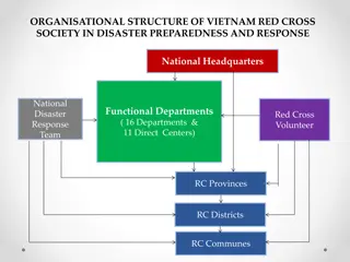
Disaster Warning Disaster Warning Disaster Warning Disaster Warning Disaster Reduction identifies several key parties that play major roles in the disaster management process, especially in disaster warning. Communities, Communities, Local governments Local governments National governments National governments Regional institutions and organizations Regional institutions and organizations International bodies International bodies Non Non- -governmental organizations (NGOs) governmental organizations (NGOs) The private sector The private sector The media The media The scientific community The scientific community
Channels Used for Disaster Warning Radio and Television Radio and Television Telephone (Fixed and Mobile) Telephone (Fixed and Mobile) Short Message Service Short Message Service Satellite Radio Satellite Radio Internet/Email Internet/Email GIS and Remote Sensing in Disaster GIS and Remote Sensing in Disaster Management Management
Disaster management in India The National Disaster Management Authority (NDMA), headed by the Prime National Disaster Management Authority (NDMA), headed by the Prime Minister of India, Minister of India, is the Apex Body for Disaster Management in India. The setting up of the NDMA and the creation of an enabling environment for institutional mechanisms at the State and District levels is mandated by the Disaster Management Act, 2005. Evolution of NDMA Evolution of NDMA Emergence of an organization is always an evolutionary process. Establishment of NDMA has also gone through the same processes. Towards this aim, the Government of India (GOI), in recognition of the importance of Disaster Management as a national priority, has set up a High-Powered Committee (HPC) in August 1999 and also a nation committee after the 2001 Gujarat earthquake, for making recommendations on the preparation of Disaster Management plans and suggestion effective mitigation mechanisms.
Floods A flood is an expanse of water submerging land. A flood is caused by excess water in a location, usually due to rain from a storm or thunderstorm or the rapid melting of snow. A flood happens when an area of land, usually low-lying, is covered with water. The worst floods usually occur when a river overflows its banks. The flood is constituted not only of the overflowing water but also of all other waters that are unable to drain off into water channels.
Causes of floods 1) When snow on a mountain melts or when a river or a lake of some sort overflows 2) Flooding from water displacement, such as in a landslide, 3) The failure of a dam, 4) An earthquake induced tsunami, 5) A hurricane s storm surge or melt water from volcanic activity. 6) Flooding of Coastal areas by high tides or by tsunami waves caused by undersea earthquakes. 7) A flood that rises and falls rapidly with little or no advance warning is called a flash flood. Flash floods usually result from intense rainfall over a relatively small area.
Elements at risk 1) Buildings built of earth (mud),weak foundation and water soluble material. 2) Basement of buildings. 3) Utilities such as sewerage, water supply. 4) Agricultural equipment and crops, vehicles, fishing boats etc.
Effects of flood 1) Physical damage- structures such as buildings get damaged due to flood water. Landslides 2) can also take place. Top soil gets washed away 3) Causalities - people and livestock die due to drowning. It can also lead to epidemics and diseases. 4) Water supplies- Contamination of water. Clean drinking water becomes scarce. 5) Crops and food supplies- shortage of food crops can be caused due to loss of entire harvest.
Flood management Flood management involves the following activities: 1) Mapping Mapping- - of the flood prone area. of the flood prone area. 2) Land use control Land use control- - no major development should be permitted in the areas subjected to no major development should be permitted in the areas subjected to flooding. 3) Construction of engineered structures Construction of engineered structures- - strong structures to withstand flood forces. strong structures to withstand flood forces. Moreover the buildings should be constructed on an elevated area and if necessary should be build on stits. 4) Flood control Flood control- - it aims to reduce flood damage. It includes: it aims to reduce flood damage. It includes: a) Flood reduction b) Flood diversion c) Flood proofing For example, o London is protected from flooding by a huge mechanical barrier across the river Thames, which is raised when the water level reaches a certain point. Notable floods Notable floods o Jakarta on January 2007 till now is having a 1.5 M flood. whole city is affected. 80 people killed. o The floods in peninsular Malaysia, Sabha and Sumithra in December 2006 and January 2007 is considered to be the worst in 100 years, resulting in evaluation of over 100,000 people in the worst-hit state of Johor at its peak. o Ethiopia saw one of its worst floods in August 2006.
CYCLONE The name cyclone was first coined by Captain Henry Piddington, Chairman of Marine Court, Calcutta in 1848. It is derived from Greek word means coil of a snake. Cyclone is an meteorological phenomena in which an area of low pressure characterized by inward spiraling winds that rotate counter clockwise in the northern hemisphere and clockwise in the southern hemisphere of the earth. Near the places of their origin they are only 80 Km in diameter, but well developed cyclones have their diameter ranging from 300 to 1500 km. They move at faster rate over the oceans than over the land because the irregularities of the land surface retard their speed. The six main types of cyclones are polar cyclone, polar low, extra tropical, subtropical, tropical and mesoscale.
EARTHQUAKE Earthquake is those movements of the earth crust which make the ground vibrate and shake backward and forward. The shaking of earth crust proceeds in the form of waves from the centre of disturbance. Longitudinal waves, transverse waves and surface waves are the 3 types of waves. Earthquake may be caused by two types of forces. 1) Tectonic occurrence: tectonic occurrence like faulting, breaking of rocks, raising or sinking of layers of the earth, folding of the strata or vapour seeking to escape from the earth. 2) volcanic activity: violent eruptions and intrusion of igneous magma from below the earth.
Types of earthquake: Types of earthquake: Volcanic earthquake: are associated with the Volcanic earthquake: are associated with the flow of hot magma interrupting volcanoes. flow of hot magma interrupting volcanoes. These These happen to be localized and seldom cause any extensive damage. Tectonic earthquake: are those which Tectonic earthquake: are those which result from structural and injustments inside the earth. Plutonic earthquake: are those which Plutonic earthquake: are those which have their origin at greater depths. They may also be generated in the same manner as the tectonic earthquake far below the surface of the earth.
Effects of earthquake: Effects of earthquake: Collapse of manmade structure like building, bridges, towers etc. Roads get affected due to subsidence of the ground and enormous fissures appear on land. Extensive landslides in hilly regions and rocky debris come down to block the path of streams. When earthquake are accompanied by volcanic activity, the destruction is very enormous. .
Mitigation measures: Mitigation measures: Damage to structure can be avoided by prohibiting restriction on such earthquake prone zones. Power lines and pipelines can be built with extra slack where they cross such earthquake prone zones. New buildings should be constructed with proper earthquake resistant measures. They require secure anchoring and tight bonding of foundations, frame, outer and inner walls, floors and roofs. Vulnerable older building located in high risk areas might be rebuilt to withstand anticipated earth quake.
Land Slides and Mitigation Land Slides and Mitigation Measures Measures In the recent years, intensive construction activity and the destabilizing forces of nature have aggravated the land Slide problem. Landslides refer to the downward sliding of huge quantities of land masses. Sliding occurs along steep slopes of hills of mountains. The rate of movement of such a mass is never constant. Landslides occur as a result of changes on a slope, sudden or gradual, either in its composition, structure, hydrology or vegetation. The changes can be due to geology, climate, weathering, changing land use and earthquakes. The causes of landslides may be grouped into two types: Inherent or internal causes. Immediate causes.
Effect of landslides: Effect of landslides: Landslides are not only destructive to the man but also to the structures. One of the most disastrous landslides occurred in Switzerland in 1806, when great masses of loose rock and soil suddenly slide down into the valley form the mountainside. It resulted in killing of 800 persons. Initially the Vajont Dam, was the highest arch failed due to landslide on October 9, 1963, when a rock mass of about 600 million tons slide down into the lake.
A significant reduction in hazards caused by landslides can be achieved by prevention of the exposure of population and facilitates by physically controlling the landslides. Development programs that involve modification of the topography, exploitation of natural resources and change in the balance load on the ground should not be permitted. Some critical measures that could be undertaken to prevent further landslides are drainage measures, erosion control measures such bamboo check-dams, terracing, jute and coir netting and rock control measures such as grass plantation, vegetated dry masonry walls, retaining walls and, most importantly, preventing deforestation and improving afforestation. Disasters cannot be totally prevented. However, early warning systems, careful planning and preparedness on part of the vulnerable community would help in minimizing the loss of life and property due to these disasters.


