Understanding Cyclones: Formation and Impact
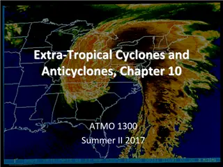
Cyclones are powerful atmospheric disturbances characterized by swirling winds and heavy rainfall. They form in warm sea conditions and progress through stages of formation, maturity, and decay. Various names are used based on location. Understanding cyclone formation helps in preparing for and managing the impact of these natural disasters.
Download Presentation

Please find below an Image/Link to download the presentation.
The content on the website is provided AS IS for your information and personal use only. It may not be sold, licensed, or shared on other websites without obtaining consent from the author. Download presentation by click this link. If you encounter any issues during the download, it is possible that the publisher has removed the file from their server.
E N D
Presentation Transcript
UNIT -II TYPES OF NATURAL DISASTERS 1) Hydrometereological Disasters Cyclones Floods Drought Desertification Thunderstorms Hail storms 2) Geographical based Disasters Earth quake Tsunami Landslides Avalanches
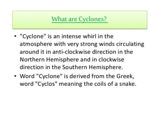
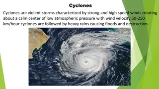
Hydrometereological Disasters Cyclones Cyclone is a region of low atmospheric pressure surrounded by high atmospheric pressure resulting in swirling atmospheric disturbance accompanied by anticlockwise direction in the Northern Hemisphere and in the clockwise direction in the Southern Hemisphere powerful winds blowing in They occur mainly in tropical and temperate regions General Characteristics Strong winds Exceptional rain Storm surge
Various Names of cyclones Typhoons in the Northwest Pacific Ocean west of the dateline Hurricanes in the North Atlantic Ocean, the Northeast Pacific Ocean east of the dateline, or the South Pacific Ocean. Tropical cyclones - the Southwest Pacific Ocean and Southeast Indian Ocean. Severe cyclonic storm (the North Indian Ocean) Tropical cyclone (the Southwest Indian Ocean) Willie-Willie in Australia Tornado in South America
Stages of Cyclone Formation The development of a cyclone covers three stages namely Formation and initial development state Fully matured Weakening or decay
Formation and initial development state: Four atmospheric/ oceanic conditions are necessary for the formation of a cyclone namely: A warm sea temperature in excess of 26 degree centigrade, to a depth of 60 meters, which provides abundant water vapor in the air by evaporation. High relative humidity (degree to which the air is saturated by water vapor) of the atmosphere to a height of about 7000 meters, facilitates condensation of water vapor into droplets and clouds, releases heat energy and induces drop in pressure. Atmospheric instability (an above average decrease of temperature with altitude) encourages considerable convection when condensation of rising air occurs. vertical cumulus cloud A location of at least 4-5 latitude degrees from the Equator allow the influence of the force due to the earth s rotation (Coriolis force) to take effect in inducing cyclonic wind circulation around low pressure centers.
Fully matured The main feature of a fully mature tropical cyclone is a spiral pattern of highly turbulent giant cumulus thundercloud bands. These bands spiral inwards and form a dense highly active central cloud core which raps around a relatively calm zone. This is called the eye of a cyclone. The eye looks like a black hole or a dot surrounded by thick clouds. The outer circumference of the thick cloud is called the eye wall .
Weakening or decay: A tropical cyclone begins to weaken as soon as its source of warm moist air is abruptly cut off. It happens, when the cyclone hits the land, Or the cyclone moves to a higher altitude Or when there is the interference of another low pressure. Cyclone may last for less than 24 hours to more than 3 weeks. On an average the life cycle of a cyclone takes six days. The longest cyclone is typhoon John which lasted for 31 days (August to September, 1994 in the north east and north west pacific basins).
Indian Cyclones 1. 7516.6 kilometers long Indian coastline is the earth s most cyclone battered stretch of the world. 2. Around 8 per cent of the total land area in India is prone to cyclones. 3. About two-third of the cyclones that occur in the Indian coastline occur in the Bay of Bengal. 4. Five or six tropical cyclones occur every year, of which two or three could be severe. 5. Winds move with a speed between 65 Km/h and 117 Km/h for cyclonic storms and for severe cyclonic storm they move between 119 Km/h and 164
S.No States / Union Territories Length of Coastline (km) Area (000 km2) Population (million) 1 2 3 4 5 6 7 8 9 10 Gujarat Maharashtra Goa 1,600 840 300 400 950 720 560 1,014 960 ---- 196.00 307.70 3.70 191.80 88.70 130.10 155.70 39.00 275.00 8.50 4.12 7.87 0.12 4.48 6.80 5.56 3.15 2.90 6.63 0.03 Karnataka West Bengal Tamil Nadu Orissa Kerala Andhra Pradesh Andaman & Nicobar Islands Lakshadweep ---- 0.03 0.005 11
Death associate with noteworthy Tropical Cyclones S.No Year Area Death Toll 1 1971 Eastern Coast 9658 2 1972 Andhra Pradesh & Orissa 100 3 1977 Chennai, Kerala & AP 14204 4 1979 Andhra Pradesh 594 5 1981 Gujarat 470 6 1982 Gujarat & Maharashtra 500 7 1984 Tamilnadu & AP 512 8 1985 Andhra Pradesh 5000 9 1990 Andhra Pradesh 957 10 1990 Andhra Pradesh 250 11 1999 Orissa 8913
Warning India has one of the best cyclone warning systems in the world. The India Meteorological Department (IMD) is the nodal department for wind detection, tracking and forecasting cyclones. Cyclone tracking is done through INSAT satellite. The cyclone warning are issued to State Government officials in four stages: i.e. of expected time of landfall. Cyclone warning is disseminated by satellite based disaster warning systems, radio, television, telephone, fax, public announcements. (i) pre-cyclone watch issued 72 hours in advance, (ii) cyclone alert issued at least 48 hours in advance , (iii) cyclone warning issued at least 24 hours in advance, and (iv) as post landfall outlook issued at least 12 hours in advance
Effects of cyclone Physical damage Structures will be damaged or destroyed by the wind force, flooding and storm surge Light pitched roofs of most structures(industrial buildings) will suffer severe damage. Casualties and public heath contamination of water supplies may lead to viral outbreaks, diarrhea, and malaria Water supplies Ground and pipe water supply may get contaminated by flood waters
Crops and food supplies high winds and rains ruin the standing crop and food stock lying in low lying areas. Plantation type crops such as banana and coconut are extremely vulnerable. Salt from the sea water may get deposited on the agricultural land and increase the salinity. The loss of the crop may lead to acute food shortage Communication severe disruption in the communication links electricity and communication towers, telephone poles, telephone lines are destroyed Transport lines (road and rail) may be curtailed Lack of proper communication affects effective distribution of relief materials
Possible Risk Reduction Measures Coastal belt plantation green belt plantation along the coastal line in a scientific interweaving pattern can reduce the effect of the hazard. Providing a cover through green belt sustains less damage. Forests act as a wide buffer zone against strong winds and flash floods. Without the forest the cyclone travel freely inland. The lack of protective forest cover allows water to inundate large areas and cause destruction. Hazard mapping Meteorological records of the wind speed and the directions give the probability of the winds in the region A hazard map will illustrate the areas vulnerable to cyclone in any given year. It will be useful to estimate the severity of the cyclone and various damage intensities in the region. The map is prepared with data inputs of past climatological records, history of wind speed, frequency of flooding etc
Land use control Least critical activities are placed in vulnerable areas. Location of settlements in the flood plains is at utmost risk. Siting of key facilities must be marked in the land use. Policies should be in place to regulate land use and building codes should be enforced Engineered structures Structures need to be built to withstand wind forces. Good site selection is also important. Majority of the buildings in coastal areas are built with locally available materials and have no engineering inputs. Good construction practice should be adopted such as: Cyclonic wind storms inundate the coastal areas. It is advised to construct on stilts or on earth mound. Houses can be strengthened to resist wind and flood damage. All elements holding the structures need to be properly anchored to resist the uplift or flying off of the objects. For example, avoid large overhangs of roofs, and the projections should be tied down.
A row of planted trees will act as a shield. It reduces the energy. Buildings should be wind and water resistant. Buildings storing food supplies must be protected against the winds and water.
Protect river embankments. Communication lines should be installed underground. Provide strong halls for community shelter in vulnerable locations Flood management Torrential rains, strong wind and storm range leads to flooding in the cyclone affected areas. There are possibilities of landslides too. Improving vegetation cover The roots of the plants and trees keep the soil intact and prevent erosion and slow runoff to prevent or lessen flooding. The use of tree planted in rows will act as a windbreak. Coastal shelterbelt plantations can be developed to break severe wind speeds. It minimizes devastating effects. The Orissa calamity has also highlighted the need for urgent measures like shelterbelt plantation along cyclone-prone coastal areas.


