Soil Surveys and Land Use Planning Insights
Unit 5: Soil Surveys &
Land Use Planning
Chapter 17
Objectives
Knowledge of purposes & uses for soil
surveys
Identify tasks for soil survey & the reports
involved
Methods of soil evaluation & interpretation
Use of electronic databases
Introduction
Soil survey
– fact-finding mission, following
by a report on the findings
Description of the characteristics of the soils
in a given area
Classification of the soils
Delineate boundaries of soils on a map
Predictions of behaviors of the soils
Introduction
Contain
Data for many users
Farmers, forecasters agronomists: evaluate potential
production of the soil, management needs to
maximize that potential
Planners, community officials, engineers, developers,
home buyers: evaluate the site for building
construction purposes, strengths, limitations
Conducting a Soil Survey
Before any surveying begins, a plan is made
& information is collected
Conferences
Collect aerial photographs
Satellite images
Initial field reviews
Conducting a Soil Survey
Preparation of a
legend
Initial field reviews conducted in soil pits in the
most extensive landforms
Soil-mapping unit:
area of soil that is
delineated from adjacent areas on a map
Differences may be:
Slope
Erosion
Soil profile
Soil Survey Reports
Normally surveyed on a county basis
Contents of a Soil Survey
Temp & precipitation
Spring/fall freeze dates
Growing season
Acreage & proportional extent of the soils
Prime farmland
Land capability & yields/ac of crops
Soil Survey Reports
Rangeland productivity
Recreational development potential
Wildlife habitat
Building site development
Sanitary facility needs
Construction materials
Water management
Engineering index
Soil Survey Reports
Physical & chemical properties of the soils
Soil & water features
Chemical analysis
Clay mineralogy
Engineering index data
Soil classification
Soil Survey Reports
Mapping Legends for Soils
Typically named for the most extensive soil series
w/in each unit
Each unit often a natural mixture of 2-5 soil-mapping
units
Called
soil associations
Delineations on the maps called
phases
of
series
Soil Survey Reports
Value of Detailed Soil Survey Reports
Most soil properties recorded in a soil survey
change very slowly
Typically
semiperminent
properties:
Land relief (topography)
Soil texture
Organic matter content
Soil lime content
Geologic origin
Soil Survey Reports
Natural fertility
Soil depth
Tendency to accumulate soluble salts
Soil structure
Soil engineering properties
Climate
Natural vegetation
Adapted crops & their expected productivity
Soil Survey Reports
Reasons why a resurvey may be done:
Some information was not gathered in a previous
survey
New management practices
Changes in crops grown
Yield prediction changes
http://soils.usda.gov
Special Soil Designations
Benchmark Soils
Considered to be of great importance in an area
Occupy a key position in the system of taxonomy
~1000 soils in the U.S. designated as benchmark
soils
Soil scientists hope that data from these soils can
be extrapolated for soils for which less
information is provided
Special Soil Designations
Prime & Unique Farmland
Lacking in many states due to many reasons
Climate extremes
Short growing seasons
Mountainous terrain
Some states contain lots of prime farmland
Ex. Jewell Co., KS – 67% prime farmland, Wayne
Co., IN – 74% prime farmland
Some counties in IA - >90% farmland
Special Soil Designations
Prime farmland soils
Best suited to producing food, feed, forage, fiber, &
oilseed crops
Soil properties that lend themselves to sustained high
yields
Need to be treated & managed using acceptable
farming practices
Adequate moisture
Growing season must be sufficiently long
High yields w/ minimal inputs
Least environmental damage
Land Evaluation
Land-use planning done for: urban areas, rural
areas
Major issues:
Quality of environment
Environmental sustainability of ag production
systems
Pollution of nitrate, phosphate, pesticides
Erosion of land
Declining soil fertility
Land Evaluation
Low-input farming
Exploitation of timber & range resources
Engineering use info
Problems caused by these issues may have
various/multiple facets
Agronomic
Economic
Political
Social
Land Evaluation
LESA system – Land Evaluation and Site
Assessment
Guide the conversion of farmland to urban uses
Attempts to preserve the best farmland
Three procedures:
Land capability classification
Current category of land is documented
Soil rated according to capability
Land Evaluation
Land Capability Classification
Classification & sub classification for all soil-
mapping units in the U.S.
Class I Soils
Can be used continuously for intensive crop
production w/ good farming practices
No restrictions
Class II Soils
More limitations than Class I land for crop production
2-5% slope is main difference
Land Evaluation
Class III Soils
Severe limitations
Requires more special conservation practices than
Class II to keep it continually productive
Can have shallow soil
Slopes 6-10%
Shallow water tables
Land Evaluation
Class IV
Severe limitations for cropping use
Greater intensity of conservation practices for
cultivated crops that Class III
Recommend permanent crops (e.g. pastures)
Slope 12-18%
Class V
Boulders, wetness, problems impractical to correct
Not necessarily erosion risk
Can’t be cultivated
Use for pasture, range, woodland, wildlife habitat
Land Evaluation
Class VI
Slope 18-30%
Same limitations as Class V soils, except more need
for sustainable management practices
Class VII
Severe limitations
Extreme care to protect the soil
Even using grazing, wildlife, timber
Slope >30%
Land Evaluation
Class VIII
Very severe limitations
Steep slopes, rock lands, swamps, etc.
Can only be used for wildlife, recreation, watersheds,
aesthetic appreciation
Land capability subclasses
– soil groups w/in
the 8 classes that explain the reasons for
limitations of intensive crop production
e – erosion hazard
w - wetness
Land Evaluation
s – shallow, droughty, stony, permafrost
c – climate too cold or dry
Land Evaluation
Ratings for Soil Potential
Indicates the relative quality of a soil for a
particular use compared with other soils in a
given area
Developed for planning purposes
Supplement land capability classes, woodland
suitability groups, range sites, soil limitation
ratings
Land Evaluation
Soil Potential Index (SPI)
– value assigned from
0-100
Yield/performance - sum of costs of corrective
measures + costs for continuing limitations
Data Interpretation for Soil Uses
Can be rated to have
slight, moderate, severe
limitations
Severe
Soil will require major soil reclamation, special
design, high costs, or intensive soil maintenance
to use for the item listed
Very Severe
Great difficulty in the soil’s use, high costs, or
both
Data Interpretation for Soil Uses
Slight & Moderate
May indicate problems w/:
Shallow
Low permeability
Strong acidity
High salt concentration
Various other problems
Data Interpretation for Soil Uses
Any soil may be good for one use, but poor
for another
Permeable, well-drained soil – good for crops,
poor for landfills, lagoons, etc.
Clayey soil w/ good, deep drainage – good for
lagoons, ponds; difficult for cropping, unstable
for roads, etc.
Controlling Land Use
Much disagreement at all levels of
government regarding how much control to
impose on land use, and whether to develop
or preserve natural resources
Land-Use Laws & Customs
Very difficult/controversial to control private
property
People generally agree that some controls are
necessary, just don’t agree on what they should be
Controlling Land Use
<1% of U.S. population are farmers
More prisoners than farmers in U.S.
Land-use regulation began w/ 1926 Standard
State Zoning Enabling Act
Gave gov’t right to zone areas for limited uses as
protection to general public
Zoning Laws
– local, regional, national gov’t ability
to guide land development
Controlling Land Use
Easements & Contracts
– used by gov’t bodies to
implement land-use planning by mandatory action
May demand easement or contract to purchase to specified
reason (e.g. park)
Easement/contract may be broken by gov’t at any time w/ no
penalty, but not by landowner
Public Purpose
– nat’l or state gov’t have authority to
purchase land for nat’l/state forests, parks, hunting
areas, flood control dams
Controlling Land Use
Private Sales or Bequests
– land trusts & holding
companies promising to protect the land
Eminent Domain
– forced legal sale due to
promotion of the general welfare of the public over
private good
Can force you to sell your land
Controlling Land Use
Recent Trends in Land-Use Controls
1 million ac of prime ag land converted to non-ag
uses each year in the U.S.
This trend has prompted some states to pass laws to
protect prime ag farmland
Limited effectiveness
No way for enforcement
Preferential Tax Assessment –
made to fit current
use of land instead of other uses that might be
assessed at higher rates
Controlling Land Use
Buying Development Rights
– owner sells
development rights to gov’t, but retains ownership to
use at its current use
Enforced Planning
– state requiring local gov’ts to
establish & enforce land-use planning, identify most
productive farmland & housing growth areas
Controlling Land Use
Threatened Farms & Farmers
Priority for U.S. to have stable, wholesome,
inexpensive food supply
All 50 states have laws against urban sprawl,
lawsuits that urban dwellers may bring against
farmers for nuisances (odor, noise, dust)
Called
right-to-farm
laws
IA Supreme Court struck down this law in 1999
What is your reaction?
What should we do to rectify the situation?
Assignment
In Chapter 17, this document delves into the essential aspects of soil surveys and their significance in land use planning. It covers the objectives, methods of evaluation, and interpretation, highlighting the role of electronic databases. This resource provides a comprehensive overview of conducting soil surveys, from initial planning to report generation, emphasizing the importance of soil data for various stakeholders such as farmers, planners, engineers, and developers. Discover the process of delineating soil boundaries, predicting soil behaviors, and utilizing survey reports for different purposes like agricultural planning, construction site evaluations, and environmental assessments.

Uploaded on Feb 16, 2025 | 0 Views
Download Presentation

Please find below an Image/Link to download the presentation.
The content on the website is provided AS IS for your information and personal use only. It may not be sold, licensed, or shared on other websites without obtaining consent from the author.If you encounter any issues during the download, it is possible that the publisher has removed the file from their server.
You are allowed to download the files provided on this website for personal or commercial use, subject to the condition that they are used lawfully. All files are the property of their respective owners.
The content on the website is provided AS IS for your information and personal use only. It may not be sold, licensed, or shared on other websites without obtaining consent from the author.
E N D
Presentation Transcript
Unit 5: Soil Surveys & Land Use Planning Chapter 17
Objectives Knowledge of purposes & uses for soil surveys Identify tasks for soil survey & the reports involved Methods of soil evaluation & interpretation Use of electronic databases
Introduction Soil survey fact-finding mission, following by a report on the findings Description of the characteristics of the soils in a given area Classification of the soils Delineate boundaries of soils on a map Predictions of behaviors of the soils
Introduction Contain Data for many users Farmers, forecasters agronomists: evaluate potential production of the soil, management needs to maximize that potential Planners, community officials, engineers, developers, home buyers: evaluate the site for building construction purposes, strengths, limitations
Conducting a Soil Survey Before any surveying begins, a plan is made & information is collected Conferences Collect aerial photographs Satellite images Initial field reviews
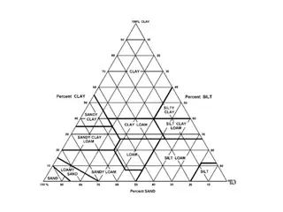
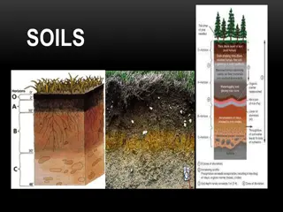
Conducting a Soil Survey Preparation of a legend Initial field reviews conducted in soil pits in the most extensive landforms Soil-mapping unit: area of soil that is delineated from adjacent areas on a map Differences may be: Slope Erosion Soil profile
Soil Survey Reports Normally surveyed on a county basis Contents of a Soil Survey Temp & precipitation Spring/fall freeze dates Growing season Acreage & proportional extent of the soils Prime farmland Land capability & yields/ac of crops
Soil Survey Reports Rangeland productivity Recreational development potential Wildlife habitat Building site development Sanitary facility needs Construction materials Water management Engineering index
Soil Survey Reports Physical & chemical properties of the soils Soil & water features Chemical analysis Clay mineralogy Engineering index data Soil classification
Soil Survey Reports Mapping Legends for Soils Typically named for the most extensive soil series w/in each unit Each unit often a natural mixture of 2-5 soil-mapping units Called soil associations Delineations on the maps called phases of series
Soil Survey Reports Value of Detailed Soil Survey Reports Most soil properties recorded in a soil survey change very slowly Typically semiperminent properties: Land relief (topography) Soil texture Organic matter content Soil lime content Geologic origin
Soil Survey Reports Natural fertility Soil depth Tendency to accumulate soluble salts Soil structure Soil engineering properties Climate Natural vegetation Adapted crops & their expected productivity
Soil Survey Reports Reasons why a resurvey may be done: Some information was not gathered in a previous survey New management practices Changes in crops grown Yield prediction changes http://soils.usda.gov
Special Soil Designations Benchmark Soils Considered to be of great importance in an area Occupy a key position in the system of taxonomy ~1000 soils in the U.S. designated as benchmark soils Soil scientists hope that data from these soils can be extrapolated for soils for which less information is provided
Special Soil Designations Prime & Unique Farmland Lacking in many states due to many reasons Climate extremes Short growing seasons Mountainous terrain Some states contain lots of prime farmland Ex. Jewell Co., KS 67% prime farmland, Wayne Co., IN 74% prime farmland Some counties in IA - >90% farmland
Special Soil Designations Prime farmland soils Best suited to producing food, feed, forage, fiber, & oilseed crops Soil properties that lend themselves to sustained high yields Need to be treated & managed using acceptable farming practices Adequate moisture Growing season must be sufficiently long High yields w/ minimal inputs Least environmental damage
Land Evaluation Land-use planning done for: urban areas, rural areas Major issues: Quality of environment Environmental sustainability of ag production systems Pollution of nitrate, phosphate, pesticides Erosion of land Declining soil fertility
Land Evaluation Low-input farming Exploitation of timber & range resources Engineering use info Problems caused by these issues may have various/multiple facets Agronomic Economic Political Social
Land Evaluation LESA system Land Evaluation and Site Assessment Guide the conversion of farmland to urban uses Attempts to preserve the best farmland Three procedures: Land capability classification Current category of land is documented Soil rated according to capability
Land Evaluation Land Capability Classification Classification & sub classification for all soil- mapping units in the U.S. Class I Soils Can be used continuously for intensive crop production w/ good farming practices No restrictions Class II Soils More limitations than Class I land for crop production 2-5% slope is main difference
Land Evaluation Class III Soils Severe limitations Requires more special conservation practices than Class II to keep it continually productive Can have shallow soil Slopes 6-10% Shallow water tables
Land Evaluation Class IV Severe limitations for cropping use Greater intensity of conservation practices for cultivated crops that Class III Recommend permanent crops (e.g. pastures) Slope 12-18% Class V Boulders, wetness, problems impractical to correct Not necessarily erosion risk Can t be cultivated Use for pasture, range, woodland, wildlife habitat
Land Evaluation Class VI Slope 18-30% Same limitations as Class V soils, except more need for sustainable management practices Class VII Severe limitations Extreme care to protect the soil Even using grazing, wildlife, timber Slope >30%
Land Evaluation Class VIII Very severe limitations Steep slopes, rock lands, swamps, etc. Can only be used for wildlife, recreation, watersheds, aesthetic appreciation Land capability subclasses soil groups w/in the 8 classes that explain the reasons for limitations of intensive crop production e erosion hazard w - wetness
Land Evaluation s shallow, droughty, stony, permafrost c climate too cold or dry
Land Evaluation Ratings for Soil Potential Indicates the relative quality of a soil for a particular use compared with other soils in a given area Developed for planning purposes Supplement land capability classes, woodland suitability groups, range sites, soil limitation ratings
Land Evaluation Soil Potential Index (SPI) value assigned from 0-100 Yield/performance - sum of costs of corrective measures + costs for continuing limitations
Data Interpretation for Soil Uses Can be rated to have slight, moderate, severe limitations Severe Soil will require major soil reclamation, special design, high costs, or intensive soil maintenance to use for the item listed Very Severe Great difficulty in the soil s use, high costs, or both
Data Interpretation for Soil Uses Slight & Moderate May indicate problems w/: Shallow Low permeability Strong acidity High salt concentration Various other problems
Data Interpretation for Soil Uses Any soil may be good for one use, but poor for another Permeable, well-drained soil good for crops, poor for landfills, lagoons, etc. Clayey soil w/ good, deep drainage good for lagoons, ponds; difficult for cropping, unstable for roads, etc.
Controlling Land Use Much disagreement at all levels of government regarding how much control to impose on land use, and whether to develop or preserve natural resources Land-Use Laws & Customs Very difficult/controversial to control private property People generally agree that some controls are necessary, just don t agree on what they should be
Controlling Land Use <1% of U.S. population are farmers More prisoners than farmers in U.S. Land-use regulation began w/ 1926 Standard State Zoning Enabling Act Gave gov t right to zone areas for limited uses as protection to general public Zoning Laws local, regional, national gov t ability to guide land development
Controlling Land Use Easements & Contracts used by gov t bodies to implement land-use planning by mandatory action May demand easement or contract to purchase to specified reason (e.g. park) Easement/contract may be broken by gov t at any time w/ no penalty, but not by landowner Public Purpose nat l or state gov t have authority to purchase land for nat l/state forests, parks, hunting areas, flood control dams
Controlling Land Use Private Sales or Bequests land trusts & holding companies promising to protect the land Eminent Domain forced legal sale due to promotion of the general welfare of the public over private good Can force you to sell your land
Controlling Land Use Recent Trends in Land-Use Controls 1 million ac of prime ag land converted to non-ag uses each year in the U.S. This trend has prompted some states to pass laws to protect prime ag farmland Limited effectiveness No way for enforcement Preferential Tax Assessment made to fit current use of land instead of other uses that might be assessed at higher rates
Controlling Land Use Buying Development Rights owner sells development rights to gov t, but retains ownership to use at its current use Enforced Planning state requiring local gov ts to establish & enforce land-use planning, identify most productive farmland & housing growth areas
Controlling Land Use Threatened Farms & Farmers Priority for U.S. to have stable, wholesome, inexpensive food supply All 50 states have laws against urban sprawl, lawsuits that urban dwellers may bring against farmers for nuisances (odor, noise, dust) Called right-to-farm laws IA Supreme Court struck down this law in 1999 What is your reaction? What should we do to rectify the situation?