Redistricting Hearing Insights and Approaches for Westchester
Explore insights and approaches for redistricting, focusing on Westchester's unique economic development, infrastructure, and socio-economic diversity. Learn about using highways and natural borders, such as parkways, to rationalize districts and maintain community interests effectively. Consider the application of these strategies to Congressional districts, including the Bronx/Westchester border and street grid continuity.

Download Presentation

Please find below an Image/Link to download the presentation.
The content on the website is provided AS IS for your information and personal use only. It may not be sold, licensed, or shared on other websites without obtaining consent from the author.If you encounter any issues during the download, it is possible that the publisher has removed the file from their server.
You are allowed to download the files provided on this website for personal or commercial use, subject to the condition that they are used lawfully. All files are the property of their respective owners.
The content on the website is provided AS IS for your information and personal use only. It may not be sold, licensed, or shared on other websites without obtaining consent from the author.
E N D
Presentation Transcript
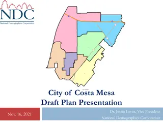
Redistricting Hearing November 8th, 2021 By: David Duarte
Opportunities with Redistricting Rationalize Districts at Congressional and State Levels Draw districts in recognition of maintaining communities of interest fairly represented in a continuous format not just geographic contiguity Enables districts to be more cohesive economically and socially for more effective representation of common needs and services I share a Westchester focused set of approaches: Recognizes Westchester s unique and diversity of economic development. Acknowledges Westchester s distinct infrastructure pattern Incorporates Westchester s rich socio-economic diversity
Approaches to Redistricting Why use Highways and Parkways as natural district borders? - Because Highways/Parkways connect and divide communities - Pro Westchester s North/South Parkway Orientation results in both economic activity and socialization patterns in a North/South manner Con Highways interrupt street grids Westchester s East/West continuity of economic and social integration is more limited versus the N/S axis. Tests to Westchester s N/S Orientation when drawing districts: Street Grid Continuity Can one walk from one side of the district to the other within reason? Is an interstate or parkway the only mode of transportation to connect? Other Natural Barriers/Connectors: Train Lines, Rivers
Application to Congressional Districts? Support for Commision s Bronx/Westchester East-West Border: - Distinct property, income and sales tax regimes - Different School Funding mechanisms and Educational Infrastructure - Physical infrastructure: no subways, simplified interstate routes - Separate Sewer Infrastructure - 100 year decision for Southern Westchester to not form part of NYC Street Grid Continuity (Recognize # s may require carve-outs and ins) New Rochelle and Pelham do not have a continuous street grid with Bronx Westchester / Bronx Continuous Street Grids include: Riverdale, Wakefield / Woodlawn with Yonkers and Mount Vernon.
Westchester Bronx Street Grids - Visualized New Rochelle and Pelham Street Grid and Sidewalks have hard stop at the Bronx Boder One cannot walk from one side of the district to another. Thus, though geogrphically contiguous, in practice, it could not form a contiguous district with the Bronx Versus Mount Vernon Street Grid and Sidewalks are relatively continuous. Even if intersections are not exact, one can walk from one side of the district to the other. Like Mount Vernon, Yonkers has a continuous street grid with the Bronx.
Carve-outs and Carve-ins for CD 16 Riverdale, Wakefield and Woodlawn neighborhoods are ideal to be carved out of Bronx to the Westchester side of CD 16 or vice-versa. Why? - Pass Street Grid Test continuous street grids - Follow North/South Orientation of physical infrastructure - Riverdale has Hudson Line Metro North Train Line, Route 9/9A and Saw Mill River Parkway / Henry Hudson Parkway connecting its neighborhoods - Wakefield and Woodlawn share Metro-North s Harlem Line as well as Bronx River Parkway as connective infrastructure to Yonkers and Mount Vernon.
Incorporating North South to CD 16/17 Westchester s Communities are unique also by natural geography - The Hudson River towns and the Hudson River watershed result in unique challenges and opportunities such as: - Environmental Pollution clean up, Brown Field investments as well as flooding - Infrastructure Mario Cuomo Bridge, etc. More hills and different infrastructure needs Economic Development transit-oriented development includes Rockland County, NYC, White Plains, Amtrak stations, riverfront, culture, arts and an important tourism sector. - Sound Shore and watershed are distinct from Rivertowns: Environmental Major flooding concerns (i.e. Hurricane Ida) Infrastructure (I-95 plus possible tunnel to Long Island?), Border with Connecticut Transit-Oriented Development with connectivity to CT, White Plains and Manhattan (Grand Central and Penn Station) plus North East Corridor Amtrak
Proposed Congressional Map CD 16 maintains Commission s: Southern Border with the Bronx East-West orientation along Cross County Parkway in Southern Westchester CD 16 pivots to then incorporate Sound Shore and the CT borderline Follows Hutchinson River Parkway, I-95, I-684 and Metro-North New Haven Lines as economic and social connective infrastructure Maintains Street Grid Continuity CD 17 is drawn more as a Rivertown District, capturing both sides of the Hudson River. Follows Route 9/9A, Saw Mill River Parkway, I-87, Sprain Brook/Taconic State Parkway, Bronx River Parkways and Metro-North Hudson and Harlem Lines as N/S connective infrastructure Challenge: Street Grids interrupted by Hudson River partially mitigated by MC Bridge walkways, bus lines and some river boat connectivity
Sample Map: CD 16 / 17 Sample CD# Estimated Population Deviation 16 (Green) 777,414 443 17 (Purple) 776,976 5 Courtesy of davesredistricting.org
Westchesters NYS Senate Maps Westchester 2020 Census Population supports approximately 3.1 NYS Senate districts. Westchester perspective: ~40k people in Westchester will be carved out to a non-Westchester NYS Senate district Easiest Carve-outs: Bronx (South Border) or Putnam County (North) Street Grid Test: Street Grid Continuity is best along Bronx border Current Commission Maps would not meet the Street Grid Test because connective infrastructure does not support the range and extent of the East-West span of current NYS Senate districts.
Proposed State Senate Maps NYS Senate District Color Population Deviation 35 Purple 319,195 -1,459 36 Yellow 315,766 -4,888 37 Blue 298,717 -21,937 Courtesy of districtbuilder.org This map is shared for illustrative purposes and is near completion. Special Mention: Mount Vernon, south of the New Have Line tracks are carved out for a Bronx based border due to the ~40k residents in a non-Westchester border. To address the deviation in #37, the district can be drawn North into New Castle or South towards the Bronx border. Yorktown can be added to #36 to mitigate if New Castle is added to #37.
Westchesters State Assembly Maps Westchester 2020 Census Population supports approximately 7.5 NYS Assembly districts. Westchester s perspective: ~61k people in Westchester will be carved out to a non-Westchester NYS Assembly district Easiest Carve-outs: Bronx (South Border) or Putnam County (North) Street Grid Test: Street Grid Continuity is best along Bronx border Northern border with Putnam County Current Commision Maps would not meet the Street Grid Test because the connective infrastructure does not support the range and extent of the East-West span of current NYS Assembly districts.
NYS Assembly Map Proposal (Rationale) Follows North-South Infrastructure Orientation more strictly it also keeps Mount Vernon in Westchester avoiding a carve out to the Bronx with more slender N/S districts. 7 NYS Assembly Districts are proposed in Westchester: 2 Rivertown Districts (from South to North): Yonkers + Dobbs Ferry Riverfront (Saw Mill River Parkway is Eastern Border) Rivertown North (Ardsley to Peekskill (N/S), SMRP border to East) 2 South Central Districts (From East to West): East Central (In Between BRP and HRP MV, Eastchester, Pelham and NR/Scarsdale) West Central (In between SMRP and BRP (East Yonkers and East Greenburgh) 3 Connecticut Border Districts (From North to South): North (North Castle and Mount Pleasant and northward) Central Westchester (North of I-95/MNR New Haven Line and East of BRP) Sound Shore (Defined by MNR New Haven Line, I-95)
Proposed State Assembly Map (2/2) NYS Assembly District Color Population Deviation 89 (Yo-Gr-River) Purple 135,003 +329 90 (Yo-Gr-East) Peach 135,045 +371 88 (MV-Eastch) Yellow 135,377 +703 93 (So. Shore) Dark Pink 136,737 +2,063 87 (WP-Har) Light Pink 130,809 -3,865 92 (Rivertowns) Green 137,629 +2,955 91 (Cen. North) Brown 133,283 -1,391 95 (N + Put Co.) Light Green 60,574 n/a Courtesy of districtbuilder.org


")