Historical Evolution of Lake Washington: From Ice Age to Urban Development
Explore the rich history of Lake Washington, spanning over 12,000 years from the Vashon Stade of the Fraser Glaciation to modern developments like the Ship Canal and Locks. Witness the gradual transformation of the lake's shoreline, the impact of major events like earthquakes, and human settlements that shaped its surroundings. Learn about the ecological changes, geological shifts, and infrastructure projects that have defined the evolution of this iconic waterbody in the Seattle region.
Download Presentation

Please find below an Image/Link to download the presentation.
The content on the website is provided AS IS for your information and personal use only. It may not be sold, licensed, or shared on other websites without obtaining consent from the author.If you encounter any issues during the download, it is possible that the publisher has removed the file from their server.
You are allowed to download the files provided on this website for personal or commercial use, subject to the condition that they are used lawfully. All files are the property of their respective owners.
The content on the website is provided AS IS for your information and personal use only. It may not be sold, licensed, or shared on other websites without obtaining consent from the author.
E N D
Presentation Transcript
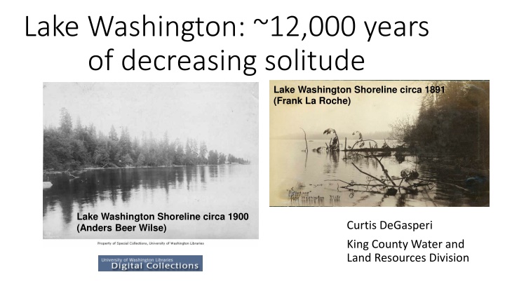
Lake Washington: ~12,000 years of decreasing solitude Lake Washington Shoreline circa 1891 (Frank La Roche) Lake Washington Shoreline circa 1900 (Anders Beer Wilse) Curtis DeGasperi King County Water and Land Resources Division
The Vashon Stade of the Fraser Glaciation 15,000-12,000 radiocarbon years ago Thickness in feet WA DNR: https://www.dnr.wa.gov/programs-and-services/geology/glaciers#the-cordilleran-ice-sheet.2
First(?) humans arrive as glaciers retreat https://www.nwcouncil.org /reports/columbia-river- history/firsthumans/
Mount Mazama ~6,800 years before present 2-inch-thick layer of ash over 12 feet below the sediment surface of the lake Sally Abella, 1988, Paleoecology, 33(6, part 1):1376-1385.
Major Earthquake ~1,100 years before present Karlin, Holmes, Abella, Sylwester, GSA Bulletin, Jan/Feb 2004, 116:94-108.
First humans still here Known village sites
Denny/Boren/Maynard submit plats for Seattle on May 23, 1853 Hyas Chuck Big Lake became Lake Washington in 1854. Coal discoveries lead to first rail lines in the late 1800s followed by road building as the population expanded beyond Seattle Logging of lowlands around the lake complete by ~1900 By 1920, raw sewage entered the lake from ~10,000 people. Big Seattle sewage project completed in 1936 Lake Washington Shoreline 1914 (Asahel Curtis) Seattle in 1878; E.S. Glover
Cedar River diverted from the Black/Duwamish to Lake Washington in 1912
Ship Canal and Locks completed 1916-1917 Ship Canal Locks Construction 1913 (Asahel Curtis) Coffer Dam at Montlake Cut 1916 (photographer unknown)
Ship Canal and Locks completed 1916-1917 Ship Canal and Locks Opening Day July 4, 1917 (photographer unknown)
Loss of shoreline wetlands, reduced natural lake level fluctuation
Lake Washington Floating Bridge circa 1940 (photographer unknown) Floating bridges facilitate east side development
Bothell ~10 MG treated wastewater entering Lake Washington each day by 1955 Between 1962 and 1965 the phosphorus input from treated wastewater was 1.9 times that of inputs from rivers and streams
Daphnia in Lake Washington (Edmondson and Litt 1982) ~10 ft!
Coalescence in the Lake Washington story Hampton et al., 2006, Limnol. Oceanogr. 51:2042-2051.
Fish (re)introductions Yellow perch introduced in late 1800s Bass (largemouth, smallmouth, rock) ? Rainbow trout stocked until 2016 Sockeye (from Baker Lake) first stocked in the Cedar River in 1930s Walleye found in Lake Washington in 2005. More since. Northern pike caught in 2017
Recent Past/Future? Relative trophic stability Struggling anadromous fish populations Climate change global warming lake becoming warmer over time SOCKEYE COUNTS BALLARD LOCKS 600,000 500,000 400,000 300,000 200,000 100,000 0 1970 1980 1990 2000 2010 2020 2030
Thanks! Curtis DeGasperi email: curtis.degasperi@kingcounty.gov phone: (206) 477-4677 Special acknowledgement: Dr. W.T. Edmondson (1916-2000) Hydrobiologia 446/447: xv-xxi, 2001.
