Geographic Concepts and Theories Explained with Images
Explore key geographic concepts and theories illustrated with engaging images, including density, toponym, relocation diffusion, Carl Ritter's Environmental Determinism, the International Dateline, map projections, and more. Learn about distance decay, space-time compression, scale on maps, and demographic transition models. Enhance your understanding of geography with visual aids.

Download Presentation

Please find below an Image/Link to download the presentation.
The content on the website is provided AS IS for your information and personal use only. It may not be sold, licensed, or shared on other websites without obtaining consent from the author. If you encounter any issues during the download, it is possible that the publisher has removed the file from their server.
You are allowed to download the files provided on this website for personal or commercial use, subject to the condition that they are used lawfully. All files are the property of their respective owners.
The content on the website is provided AS IS for your information and personal use only. It may not be sold, licensed, or shared on other websites without obtaining consent from the author.
E N D
Presentation Transcript
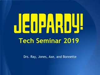
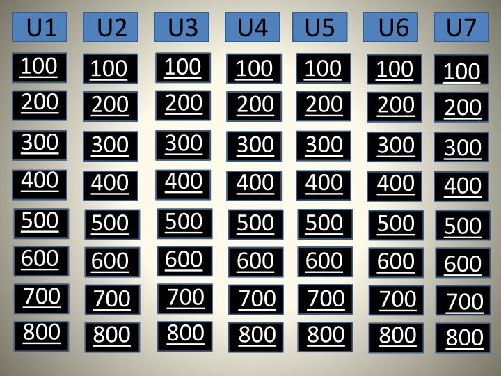
U1 100 200 U2 U3 100 200 U4 U5 U6 U7 100 200 100 200 100 200 100 200 100 200 300 300 300 300 300 300 300 400 400 400 400 400 400 400 500 500 500 500 500 500 500 600 600 600 600 600 600 600 700 800 700 800 700 800 700 800 700 800 700 800 700 800
Density The number of objects per unit of land area Unit 1 100
Toponym, Site, Situation, Absolute Location These are the four ways to identify a location Unit 1 200
Relocation and Expansion Diffusion The difference between these two is whether the phenomenon stays strong in its hearth (node) Unit 1 300
Carl Ritter This man developed the idea that the environment shapes the way in which societies develop, called Environmental Determinism. Of course he did not believe in the alternative approach of Possiblism. Unit 1 400
International Dateline If you started traveling East from GMT, you would cross this after you passed through 12 time zones. Unit 1 500
Robinson and Mercator Name these two map projections Unit 1 600
Distance Decay; Space-time Compression ______ is the idea that the further apart two places are, the less likely they are to interact. However, the technology has allowed information to travel further, faster, which is known as the ______ Unit 1 700
The larger the scale the more detail How does a map s scale relate to the amount of detail that it displays? Unit 1 800
Stage 2 What stage of the DTM is this country in? Unit 2 100
Higher land prices in urban centers causes people to decide to have smaller families While the Industrial Revolution and the 2nd Agricultural Revolution were responsible for lowering CDR s and moving countries into stage 2, what is responsible for the drop in CBR s we see in Stage 3 and into Stage 4? Unit 2 200
Push and Pull Factors Examples include an earthquake destroying a town, a pleasant job offer, and war. Unit 2 300
Stage 2 Thomas Malthus saw population growing geometrically or exponentially and food/resources growing arithmetically once England hit this stage of the demographic transition model Unit 2 400
Single Males ages 25-33 According to Ravenstein s migration laws: Migrants travel short distance Migrants who travel further go to large cities. Rural residents are more likely to migrate than urban. And ______ are most likely to migrate internationally Unit 2 500
Evolution of Infectious Diseases The Epidemiologic Transition Model, which explains the causes of death at each stage of the Demographic Transition Model, predicts a possible stage 5 in which ______ drives death rates back up Unit 2 600
Gravity Model This model says that a location s likelihood as a destination of migrants is directly related to its population and inversely related to the distance they must travel to get there. Double Daily Unit 2 700
Demographic Momentum A population pyramid with a wide base has ______, meaning that even if the TFR s dropped the population would continue to grow because of the larger % of population in their youth. Unit 2 800
Universalizing These religions holidays are typically based around an event in the founder s life. Unit 3 100
Ethnic These religions holidays are typically based around the seasons and the environment. Unit 3 200
Mandarin Chinese, Spanish, English What are the 3 largest languages in the world? Unit 3 300
Ethnicity- Culture Race Physical Characteristics What is the difference between Ethnicity and Race Unit 3 400
Christianity and Islam Identify the Religions in Purple and Green Unit 3 500
Hinduism and Buddhism Identify the religions represented by Red and Yellow Daily Double Unit 3 600
Ethnic Cleansing is removing a cultural group. Genocide is ethnic cleansing through death What is the difference between genocide and ethnic cleansing? Unit 3 700
Syncretic Confucianism and Buddhism are often practiced together in East Asia because they are both _____ meaning they allow their followers to practice more than one faith. Unit 3 800
State: Country Nation: Cultural Group Nation-State: Country with a culturally uniform population Define State, Nation, and Nation State Unit 4 100
Great Britain is a fragmented country because Northern Ireland is separated from the rest of the state by the Irish Sea. How would you classify Northern Ireland? Exclave Daily Double Unit 4 200
Heartland Theory; Rimland Theory Mackinder believed in the _______ however Spykman s ________ seemed to know his weakness. Unit 4 300
Federal Govt. States with large landmass are more likely to experience a wide variation of preferences between far ends of their territory. As a result they often form these types of govts. Unit 4 400
Balkanization Despite its attempts at devolution Yugoslavia eventually broke into several new States. Because the new boundaries were drawn around existing cultural groups, many of the new states were Nation-States. This process is known as ______ Unit 4 500
Land Empire When Francisco Pizarro was conquering Lima he was expanding this type of colonial empire. Unit 4 600
Friedrich Ratzels Organic Theory This man developed a theory that States are indeed alive and need to conquer in order to thrive. Unit 4 700
Dependency Theory or Neocolonialism This explains that many countries are poor today because of their prior colonization by European powers. Former colonies have not been able to heal from the imperial domination established by the colonizers. Unit 4 800
Commercial; Subsistence The two main types of agricultural which specify their purpose, size of farms, agricultural density, use of machinery, and its place in the economy. Unit 5 100
Extensive: low yields on a lot of land Intensive: high yields on a little land Compare extensive and intensive agriculture in terms of the yields per amount of land. Unit 5 200
Extensive Subsistence Shifting Cultivation, Slash and Burn, Pastoral Nomadism, and Transhumance all fit into this category of agriculture Unit 5 300
Primary Countries that do not have agribusiness tend to have a large amount of workers employed in which economic sector? Unit 5 400
Dairy Farms This type of commercial agriculture is very labor-intensive and is located in NE United States due to it s proximity to the market. The farms that are located further from the market typically process their product instead. Unit 5 500
Von Thunen According to this man, different agriculture is used in different places based upon how quickly it will spoil and how much it will cost to transport it. Unit 5 600
3rd Agricultural Revolution or Green Revolution This is the only agricultural revolution of the three that did not give rise to Urbanization. Unit 5 700
What type of Commercial Agriculture is in Red? Plantations Unit 5 800
Agglomeration When industries cluster in one location in order to share resources and services. Unit 6 100
Primary: Farming Secondary: Manufacturing Tertiary: Services Describe what a worker in each of the first three economic sectors might be doing each day to earn a living Unit 6 200
Life Expectancy: Long Education Level: High Literacy Rates: High Standard of Living (GDP): High Country X ranks .934 on the HDI. Estimate where they stand on each of the four factors that go into calculating the HDI. Unit 6 300
What stage of the Demographic Transition Model would this country be in and in which economic sector would they employ the most people? Stage 4 and the Tertiary Sector Population 1200000 1000000 800000 600000 Population 400000 200000 0 City 1 City 2 City 3 City 4 City 5 Unit 6 400
Core-Periphery Wallerstein s World System-Analysis explains that the More Economically Developed Countries, which he calls ______, only exist because they exploit the Less Economically Developed Countries aka __________. He claims that the MDC s only exist because of the LCD s and never will we see a world with 100% development. Unit 6 500
High: TFR, CBR, NIR, IMR Country Y ranks .345 on the HDI. Estimate if the following rates are high or low: TFR CBR NIR IMR Unit 6 600
Footloose Industries Weber s least cost theory states that most industries need to consider situation factors in relation to the market and their resources in order to reduce transportation costs. However, _______ Industries can locate anywhere because the cost of transporting their raw materials or finished goods is not important. Therefore they tend to locate near skilled labor. Example: Computer Chips Unit 6 700
Maquiladoras Many US companies take advantage of low wages in these factories which are located outside of the US Govt s jurisdiction Unit 6 800
Western Europe: Urban Sub-Saharan Africa: Rural India: Rural Using the terms Rural and Urban , describe the population of the following locations: Western Europe Sub-Saharan Africa India Unit 7 100