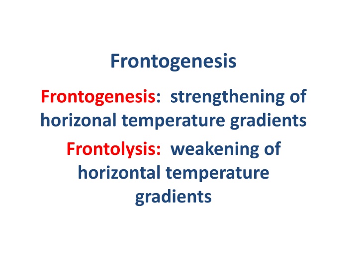
Frontogenesis and Frontolysis in Meteorology
Meteorology enthusiasts can explore the concepts of frontogenesis and frontolysis, the evolution of cyclones, and the role of the Norwegian School Meteorologists in describing fronts. Dive into the mechanisms behind the formation and weakening of horizontal temperature gradients, the interaction between wind and temperature fields, and the key components of kinematics shaping weather patterns.

Download Presentation

Please find below an Image/Link to download the presentation.
The content on the website is provided AS IS for your information and personal use only. It may not be sold, licensed, or shared on other websites without obtaining consent from the author.If you encounter any issues during the download, it is possible that the publisher has removed the file from their server.
You are allowed to download the files provided on this website for personal or commercial use, subject to the condition that they are used lawfully. All files are the property of their respective owners.
The content on the website is provided AS IS for your information and personal use only. It may not be sold, licensed, or shared on other websites without obtaining consent from the author.
E N D
Presentation Transcript
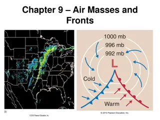
Frontogenesis Frontogenesis: strengthening of horizonal temperature gradients Frontolysis: weakening of horizontal temperature gradients
The Norwegian or Bergen School Meteorologists in the early 20thcentury were the first to describe fronts and their evolution Bjernkes, 1919
Concept of Evolution of Cyclones Bjerknes and Solberg 1922
Stationary Polar Front Wave Forming on Polar Front
Wave Amplifies Occlusion as Cold Front Catches Up to Warm Front
The Norwegian Cyclone Model Started with a Strong Polar Front and Had Limited Discussion of How Fronts Formed
Why are there fronts? First attempts were based on the kinematic description of frontogenesis Kinematics regards the description of motions rather than the forces driving motions How do wind and temperature fields interact to increase temperature gradients?
With a pre- existing temperature gradient, certain wind fields can concentrate the temperature gradient, resulting in frontogenesis
Kinematics 101: the wind around a point can be linearly decomposed into four key components Translation Rotation Divergence Deformation
Translation: movement in one direction
Rotation (cyclonic or anticyclonic) clockwise counterclockwise) Anticyclonic (NH) Cyclonic (NH) Northern Hemisphere
The flow around a point can be decomposed into these kinematic components Combining these components can produce many important flow fields
Deformation Plus Translation Results in Confluence
Bergeron (1928) was the first to show that fronts could form/strengthen when deformation acts on a preexisting temperature gradient. T- T T T+ T T+2 T T+3 T T+4 T
Bergeron also showed that the orientation of isotherms was important: had to be within 45 of the axis of dilation to get frontogenesis
Peterssen (1936) showed that convergence can force frontogenesis cool warm
Peterssen Created a Frontogenesis Function ? ????? , , two dimensional/horizontal Lagrangian Lagrangian viewpoint: how does temperature gradient vary following the flow. flow. Related ? to temperature gradient, deformation and divergence ? = two dimensional/horizontal following the
Frontogenesis Function (2D) ? = ??? (DEF*cos2 DIV) DEF is deformation and DIV is divergence is the angle between the isotherms and the axis of dilation
Frontogenesis Function (2D) ? = ??? (DEF*cos2 DIV) Negative divergence (convergence) forces frontogenesis Deformation with an angle less that 45 produces frontogenesis Stronger temperature gradient enhances F
Both convergence and deformation contribute to frontogenesis for a typical midlatitude cyclone
Theoretical Studies in the 1940s and 1950s Showed That Synoptic Scale Deformation and Convergence Was NOT Enough to Rapidly Produce Mesoscale Fronts The secret was learned in the 1950s. Mesoscale processes are needed for the final and rapid concentration of temperature gradients.
Synoptic Scale Winds Alone Warm air Cold air
Secondary Circulations: Help Tighten Up Front! Cold air Warm air
Secondary Circulations Occur to Attempt to Retain Thermal Wind Balance Cold air Warm air
Typically, low-level fronts weaken with height (horizontal temperature gradients lessen with height)
Why do fronts weaken away from the surface? Vertical motions!
Vertical motions increase with height and weaken temp. gradient Adiabatic cooling on warm side Adiabatic warming On cold side Warm air Cold air Thus, the effects of vertical motions on temperature increase with height
Vertical motions can also create and maintain fronts in some locations Near the tropopause, vertical motions can create/strengthen upper-level fronts. Horizontal ariations in vertical motion can produce horizontal temperature gradients through a mechanism called tilting.
Higher Potential Temperature Adiabatic warming UP Adiabatic cooling Lower Potential Temperature Vertical Motions Can Create a Temperature Gradient Called tilting frontogenesis
Fronts often develop and strengthen during midlatitude cyclone development Frontogenesis and cyclogenesis go hand in hand!


")
")


 was the first to show that fronts")


 showed that convergence can")

")
")