Synoptic Meteorology: Fronts and Weather Phenomena
Fronts are boundary surfaces that separate air masses of different densities, leading to various meteorological phenomena. Cold fronts, warm fronts, occluded fronts, and stationary fronts impact weather patterns differently, affecting temperature, moisture levels, and wind direction. Understanding these fronts helps predict weather changes accurately.

Uploaded on Sep 17, 2024 | 2 Views
Download Presentation

Please find below an Image/Link to download the presentation.
The content on the website is provided AS IS for your information and personal use only. It may not be sold, licensed, or shared on other websites without obtaining consent from the author.If you encounter any issues during the download, it is possible that the publisher has removed the file from their server.
You are allowed to download the files provided on this website for personal or commercial use, subject to the condition that they are used lawfully. All files are the property of their respective owners.
The content on the website is provided AS IS for your information and personal use only. It may not be sold, licensed, or shared on other websites without obtaining consent from the author.
E N D
Presentation Transcript
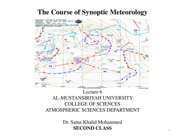
The Course of Synoptic Meteorology Lecture 6 AL-MUSTANSIRIYAH UNIVERSITY COLLEGE OF SCIENCES ATMOSPHERIC SCIENCES DEPARTMENT Dr. Sama Khalid Mohammed SECOND CLASS 1
Front Fronts are a boundary surfaces that separate air masses of different densities (warmer and moister) than the other and are the principal cause of meteorological phenomena. front has horizontal and vertical extent, the upward extension of a front is referred to as a frontal surface, or a frontal zone. As one air mass moves into another, the warmer (less dense) air mass is forced aloft in a process called overrunning. The general properties of fronts are: sharp temperature contrast (isotherms lines will be tightly packed near frontal zone) and packing will be greatest on cold side of front on a weather map moisture contrast and cyclonic wind shift.
In general, the sharper temperature contrast across the front and the faster front moves, the weather will be more severe, which is why cold fronts are more violent than warm fronts as we will see later. Falling pressure means front hasn t yet passed, while rising pressure means front has passed. Sometimes, fronts are dry, meaning that even though there is uplifting along the front and there is not enough moisture to cause clouds or precipitation. Fronts lie in a trough There are four types of fronts: cold fronts warm fronts occluded fronts stationary fronts
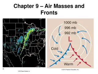
A weather map showing surface-pressure systems, air masses, fronts, and isobars (in millibars) as solid gray lines. Large arrows in color show air flow. (Green-shaded area represents precipitation.)
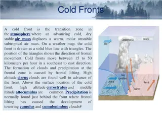
Cold Front Represents a zone where cold, dry stable polar air is replacing warm moist unstable tropical air. The cold front is represented by a blue line with triangles pointing the direction of cold air moving. Cold fronts generally move from northwest to southeast. The cold air that's arriving behind a cold front is colder and drier than the air ahead of it. When a cold front passes through, temperatures can drop more than 15 degrees within the first hour, while the temperature difference across the front can be small. The Pressure Falls steadily before passing , minimum at passing, rises after. Precipitation Showers before; heavy precip. at front, snow; precip. decreases then clearing Visibility Hazy before; poor at front; improving after Dew point High before; sharp drop when pass; lowering after.
As a cold front moves into an area, the heavier, cool air pushes under the lighter, warm air and replacing it, and the warm air cools as it rises. Weather at a cold front is determined by the moisture content of the warm air mass, and the temperature and dew point usually decreases through the front passes. The leading edge of the front is steep, steepness due to friction. Distance from leading edge of front to cold air =100 km. But the front aloft is about 1 km over our head. Thus it is said to have a slope of 1:100 This is a fast moving front, slow moving fronts have less slope front moves forward at 9 16m/s (much faster than warm front).
Cold fronts come in many varieties, including some that quickly bring clearing skies, and some that are followed by Cb, Cs and Ci clouds and rain. If thunderstorms are associated, a scud roll or wall of dust will mark the front near the ground. Precipitation ahead of a cold front can be continuous, but behind the front, becomes showery. Winds ahead of a cold front tend to be from a southerly direction while those behind the front - in the cooler air - tend to be northerly. Surface winds veer and increase or become gusty. When wind direction shift from a southerly to a northerly indicating that a cold front has passed
Warm Front A warm front is the boundary between warm and cold air when the warm air is replacing the cold air Warm fronts generally move from southwest to northeast and the air behind a warm front is warmer and moister than the air ahead of it. As the warm air advances it rides over the cold air, which is heavier. As the warm air rises the water vapor in it condenses into clouds that can produce rain, snow, sleet or freezing rain, often all four, so it is easy to assume that the weather at a warm front is determined by the moisture content, the stability of the warm air, and the degree of overrunning (warm air over top the cold). The warm front represented by semi-circles on the red line point in the direction of warm air moving.
Vertical view of clouds and precipitation across the warm front
Vertical view of the temperature and winds across the warm front
This is why a slow-moving warm front can mean hours, if not days, of cloudy, wet weather before the warm air finally arrives. The frontal surface slopes very shallowly with height (about 1:200) and the front moves forward at 7 - 9 m/s. The passage of the front is accompanied by, a gradual veer of wind direction, increase in temperature and dew point, layer type cloud with light continuous precipitation and the pressure falls as the front approaches, then becomes steady or rises as the front passes. Along warm front boundary clouds such as St, Ns , As, Cs, Ci and precipitation, can stretch hundreds of kilometers over the cold air.
Stationary Front A front with essentially no movement Drawn as alternating red and blue line. Semicircles face toward colder air on the red line and triangles point toward warmer air on the blue line. Winds tend to blow parallel to a stationary front. If either a cold or warm front stops moving, it becomes a stationary front If the stationary front starts moving north in the example ubove, it will become a????
Occluded Fronts It is the boundary that separates the new cold air mass (to the west) from the older cool air mass already in place north of the warm front, it means when a cold front overtakes a warm front. When a cold front catches up to and overtakes a warm front, the frontal boundary created between the two air masses is called an occluded front or simply an occlusion
Represented as a solid purple line with alternating cold front type triangles and warm front half circles. Changes in temperature, dew point temperature, and wind direction can occur with the passage of an occluded front. Two types: Warm and cold occlusions; Warm occlusion is, when air behind cold front is warmer than air ahead of warm front, and almost have the same characteristics associated with warm front. Cold occlusion is, when air behind cold front is colder than air ahead of warm front and almost have the same characteristics associated with cold front.
Occluded Front Development Phase 1: Phase 2
The formation of a warm-type occluded front. The faster-moving cold front in (a) overtakes the slower-moving warm front in (b). The lighter air behind the cold front rises up and over the denser air ahead of the warm front. Diagram (c) shows a surface map of the situation.
The formation of a cold-occluded front. The faster-moving cold front (a) catches up to the slower-moving warm front (b) and forces it to rise off the ground (c) (Green-shaded area represents precipitation.)