FireMapper Enterprise: Enhancing Wildfire Management
FireMapper Enterprise is a comprehensive mapping system designed to assist in managing wildfires effectively. It offers offline functionality, easy fireground feature addition, live map generation, resource tracking, and seamless information sharing between systems. Access is tailored for administrators, executive officers, and coordination centers, enabling efficient incident management and decision-making.

Download Presentation

Please find below an Image/Link to download the presentation.
The content on the website is provided AS IS for your information and personal use only. It may not be sold, licensed, or shared on other websites without obtaining consent from the author.If you encounter any issues during the download, it is possible that the publisher has removed the file from their server.
You are allowed to download the files provided on this website for personal or commercial use, subject to the condition that they are used lawfully. All files are the property of their respective owners.
The content on the website is provided AS IS for your information and personal use only. It may not be sold, licensed, or shared on other websites without obtaining consent from the author.
E N D
Presentation Transcript
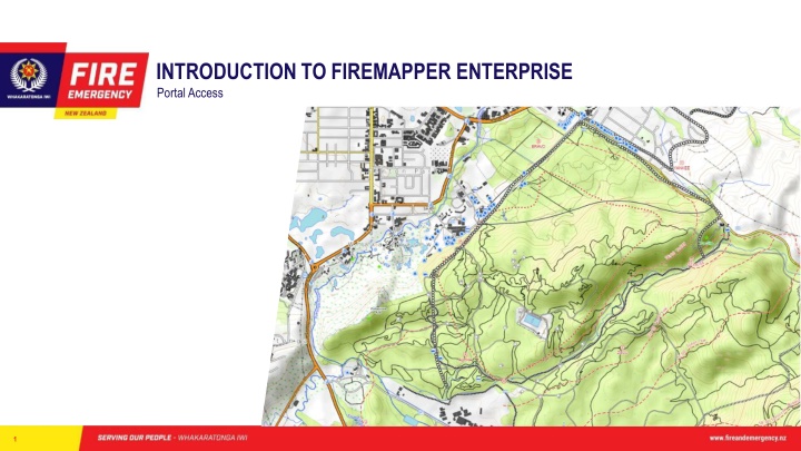
INTRODUCTION TO FIREMAPPER ENTERPRISE Portal Access 1
WHY FIREMAPPER ENTERPRISE? Needs assessment identified a good wildfire mapping system should include: Offline functionality Easily add fireground features Linking between devices to generate a Live Map Aid tracking of resources Share information with other systems. Import and export spatial information. FireMapper Enterprise's functionality stood out against other options when measured against the needs assessment. 2
What is Fire Mapper Enterprise and how does it work? Front line Key Points and line data Base Layer tiles (images) Location tracking ( Mobile device tracking Other GIS data Supporting resources IMT / RCC ALPS Archaeological points Internet data eg. Traffic / roadwork information Lifeline services Incident data FENZ GIS Arena aircraft locations Stakeholder land parcels 3
What access is available to who? 18 Administrators (can issue access). One person per district as listed on the portal page. 100 Licences for Executive Officers who respond to and manage Veg fire Initial attack and a selection of others who work at a similar level such as external Air Attack Supervisors 20 Shared Licences can be issued to somebody for up to 14 days. Portal Access - Coordination Centres and Command Units Tokens for temporary portal access can be issued as required. Access will be reviewed after year one. 4
Fire ground IMT NCC / RCC Exec Officer receives call, searches location and assesses with fire mapper recognises fire is likely to escalate Exec Officer arrives & becomes IA-IC of escalating fire - changes map to shared and adds basic features incl sectorisation during recon flight. IA-IC arranges licences for Sector Supervisors Requests IMT IMT Gains access to map for management of the incident, and also orders a mapping specialist 5
Fire ground IMT NCC / RCC Exec Officer receives call, searches location and assesses with fire mapper recognises fire is likely to escalate Exec Officer arrives & in this case becomes IA-IC of escalating fire - changes map to shared and adds basic features incl sectorisation during recon flight. IA-IC arranges licences for Sector Supervisors Requests IMT IMT Gains access to map for management of the incident, and also orders a mapping specialist Coordination centres obtain basic situational awareness of escalating incident and provide managers, media team, etc outline of situation. Intelligence Unit monitors map input quality. While mapping specialist uses fire mapper to monitor current situation and uses other tools for analysis of impacts and likely incident development. Operations Mgr, Air Operations and Sector Supervisors keep the fireground map up to date PIM / Liaison able to produce maps for Public and share live maps where appropriate Mapping specialist adds features from other sources, such as thermal flights and forestry data Operations, use detailed, live maps to plan and implement tactics of the response 6
Using the portal https://portal.firefront.com.au/ Use Chrome or Microsoft Edge Internet explorer may not have full functionality Available current maps Archived Maps (removed from list on devices) For personal, coordination centre and ICU email accounts that have been issued FireMapper portal access go to https://portal.firefront.com.au/ and use the forgotten password process to get started. 7
Viewing maps Recommended for ICP, ICU, RCC and stakeholder viewing: Activity Allows Navigation to recently added features Features - allows feature types to be turned off to manage map clutter on screen and exported maps Layers - change depending on map extent and include some near real time satellite imagery at wide extents. Export - options similar to the app - NB: Use the print preview allows edition of the Title, Key etc. 8
Custom map generation Select Open Print Preview Edit Map Titles and Key Adjust map settings Map size Grid system Base layer Adjust View Zoom Turn grids on/off Base Layer 9
Quick reference guides on FENZ Portal Page under tools and applications / Response Capability District / Regional Administrators listed on the FENZ Portal National Administrators Wildfire and GIS Team. FireFront solutions (Via National Admin) Support and assistance 10