A River from Source to Sea
Explore the transformation of rivers and surrounding landscapes from the source to the sea. Discover how natural and man-made processes shape river channels, create diverse landforms, and influence the flow dynamics. Follow the evolution of a river from its hilly beginnings to the wide expanses at its mouth, understanding the impact of erosion, deposition, and human interventions along the way.

Download Presentation

Please find below an Image/Link to download the presentation.
The content on the website is provided AS IS for your information and personal use only. It may not be sold, licensed, or shared on other websites without obtaining consent from the author.If you encounter any issues during the download, it is possible that the publisher has removed the file from their server.
You are allowed to download the files provided on this website for personal or commercial use, subject to the condition that they are used lawfully. All files are the property of their respective owners.
The content on the website is provided AS IS for your information and personal use only. It may not be sold, licensed, or shared on other websites without obtaining consent from the author.
E N D
Presentation Transcript
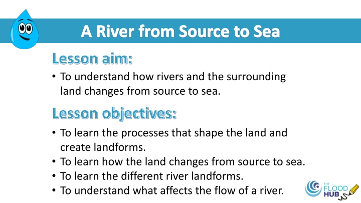
A River from Source to Sea Lesson aim: To understand how rivers and the surrounding land changes from source to sea. Lesson objectives: To learn the processes that shape the land and create landforms. To learn how the land changes from source to sea. To learn the different river landforms. To understand what affects the flow of a river.
Source to mouth Where a river starts is called the source, this is in hilly, upland or mountainous areas. Where a river ends is called the mouth, this is at the sea or a lake. Source Mouth Image: The Flood Hub This video follows the route of a river from source to mouth: https://www.bbc.co.uk/bitesize/topics/z849q6f/articles/z7w8pg8
Why do rivers change over time? Rivers can change naturally or the changes can be man-made. Rivers never stay the same, they change all the time. These are some of the processes which can shape the landscape, the river s channel and create landforms. Weathering is the breaking down or wearing away of rocks where they are. It does not happen because they move or crash into each other. Erosion is when materials such as rock, soil and sand are broken down and worn away by rain, rivers, wind or waves, and are then moved away. is when the eroded materials are left behind because the river, wave or Deposition wind slows down.
A natural river Water flows slower through an unchanged, natural river channel This is due to the curved shape of the channel which slows the flow of water. Image taken from West Cumbria Rivers Trust Natural rivers for life A short guide to restoring natural rivers in Cumbria - Design & illustration by Custard Graphic Design
A straightened river Water flows much quicker through a straightened river channel as water can easily flow through. Image taken from West Cumbria Rivers Trust Natural rivers for life A short guide to restoring natural rivers in Cumbria - Design & illustration by Custard Graphic Design
Changes in the land around a river and the channel A river can be split into three sections: Upper course Middle course Lower course The first third of a river. The second third of a river. The last third of a river. Begins in hills and mountains (the source) Steep slopes Narrow valley sides Narrow, shallow river channel with a rocky bed Gentler slopes Wider, deeper channel Ends at the sea or a lake (mouth) Low lying, flat land Gentle, wide valleys Wide channel and fastest flow
River landforms Source Upper course Lower course Middle course Waterfall River channel Meander Tributary Estuary Sea or lake Floodplain Oxbow lake Mouth Image: The Flood Hub A river landform is a natural feature created by a river on the Earth s surface.
River landforms Upper course V-shaped valley A v-shaped valley is created when a river erodes both vertically and horizontally. Image: The Flood Hub
River landforms Upper course Waterfall A waterfall is a steep drop in the course of a river. They form when water flows over hard rock that overlies softer rock. Video: https://www.bbc.co.uk/bitesize/guides/zyt9q6f/revision/4 Image: The Flood Hub
River landforms Middle and Lower course Meander Meanders are a bend in the river channel created by the speed of the water, erosion and deposition. Image: The Flood Hub
River landforms Middle and Lower course Oxbow lake An oxbow lake is a curved lake created when the gap between a meander bend gets smaller and the river takes the straighter, quicker route through the land instead of flowing around the meander. Video: https://www.bbc.co.uk/bitesize/guides/z6jx382/revision/4
River landforms Middle and Lower course Floodplain A floodplain is the flat land next to a river where water flows when a river overtops during a flood. Image: The Flood Hub
River landforms Lower course Levee A levee can form naturally or be built alongside the river on the floodplain. They are a raised bank of a river that protects against flooding. Levees River channel Image: The Flood Hub
River landforms Lower course Estuary Sea An estuary is the point where a river meets the sea. At this point, freshwater from the river mixes with the saltwater from the sea. River
Recap Source Upper course Lower course Middle course Waterfall River channel Meander Tributary Estuary Sea or lake Floodplain Oxbow lake Mouth Image: The Flood Hub
Card game Let s play a card game! Match the small cards to the course of the river that they are found in. Some cards are the same because they are found in more than one section of the river.
What affects the flow of a river? Man-made effects Urban areas Deforestation The water cannot soak into the ground and enters the river quicker which increases flow. When trees are chopped down, water isn t soaked up by the trees and leaves. Water enters the channel quicker and increases flow. https://www.kindpng.com/picc/m/228-2288709_transparent-cityscape-png- cartoon-building-clipart-png-png.png Flood walls Drainage of farmland Flood walls can change the flow of water by keeping more water in the channel, stopping it flowing naturally onto the floodplain. Farm machinery compacts soil and water cannot soak into the ground. The water runs off and enters the river quicker, increasing flow.
What affects the flow of a river? Natural effects The steepness of the catchment The size and shape of the catchment Water reaches the river channel quicker when the slopes of the catchment are steeper. Water reaches the river channel quicker in smaller, narrow catchments, compared to large, round ones. Image: The Flood Hub Image: The Flood Hub A catchment is an area of land that leads each drop of rain that falls within it towards the same river. Vegetation cover Weather and climate Areas with grass instead of concrete allow water to soak into the ground, which slows down and decreases the flow. Areas that have more rainfall throughout the year will have rivers with bigger flows. Image: Petr Kratochvil via Public domain pictures.net
What affects the flow of a river? Don t forget . A natural, meandering channel slows the flow of a river. Weather and climate Size and shape of the river catchment Tree cover - deforestation Drainage of farmland A straightened channel speeds up the flow of water. Urban areas Flood walls Vegetation cover
Map Reading Note down the grid references of the river landforms and places listed on the worksheet.
Recap of lesson Rivers and landscapes change over time due to three processes weathering, erosion and deposition. Rivers can be split into three sections the upper, middle and lower course. A natural river channel slows the flow of water in a river. A straightened river channel speeds up the flow of water in a river.
Homework Complete the river landforms homework sheet by matching up each type of landform with which course it is in and the description of it.