
Localised Adaptive Spatial-Temporal Graph Neural Network
This paper introduces the Localised Adaptive Spatial-Temporal Graph Neural Network model, focusing on the importance of spatial-temporal data modeling in graph structures. The challenges of balancing spatial and temporal dependencies for accurate inference are addressed, along with the use of distri
6 views • 19 slides

Introduction to Spatial Data Mining: Discovering Patterns in Large Datasets
Spatial data mining involves uncovering valuable patterns from extensive spatial datasets, offering insights into historical events, environmental phenomena, and predictive analytics. Examples range from analyzing disease outbreaks to predicting habitat suitability for endangered species. The applic
4 views • 20 slides
Spatial Database Systems: An Overview
This presentation by Xiaozhi Yu introduces the fundamentals of spatial database systems, covering topics such as spatial data types, relationships, system architecture, modeling, and organizing underlying spaces. It delves into the importance of integrating geometry into DBMS data models, spatial in
8 views • 30 slides
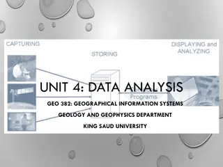
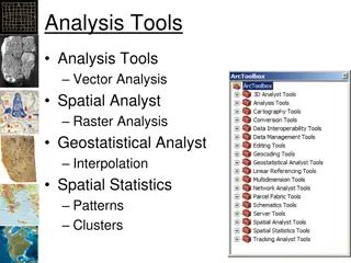
Spatial Analysis in GIS for Effective Decision-Making
Spatial analysis in GIS involves modeling geographic problems, processing data, and exploring results to understand spatial relationships, patterns, and suitability for various purposes. GIS tools offer unique capabilities for handling geographically referenced data, data entry, storage, manipulatio
6 views • 21 slides

Spatial Referencing Systems for Mapping
Spatial reference systems play a crucial role in defining geographic parameters and coordinate systems for mapping. They consist of components like orientation, latitude, longitude, and elevation, which help in representing spatial properties on maps. Reference surfaces such as the Geoid and ellipso
10 views • 13 slides

Spatial Analysis & Modeling for Spatial Planning Training in Maputo, Mozambique
Explore spatial analysis techniques for efficient route planning, site selection, pattern identification, and value prediction in the context of spatial planning. Learn about surface modeling, relationships among features, and the importance of spatial modeling in addressing geographical problems.
0 views • 27 slides

GIS Data Models for Spatial Planning Training in Maputo, Mozambique
Explore the concepts of GIS data models including vector vs. raster, spatial relationships, spatial operations, and representation of real-world entities in a spatial database. Understand how spatial data models are used to manipulate spatially-referenced information and define the spatial location
3 views • 32 slides
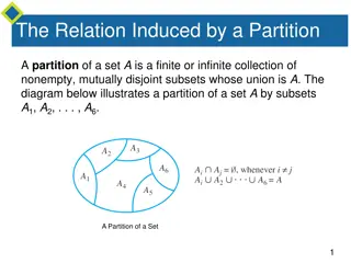
Equivalence Relations and Partition Induced Relations
The concept of equivalence relations and partition-induced relations on sets are explored. Equivalence relations satisfy reflexivity, symmetry, and transitivity, making them important in various mathematical contexts. The relation induced by a partition of a set is shown to be an equivalence relatio
7 views • 24 slides
Spatial Autocorrelation in Geostatistical Analysis
Explore the concept of spatial autocorrelation, its implications in geostatistical analysis, and the importance of detecting and interpreting it correctly. Learn about auto-correlation, signal components, correlation significance, and measuring autocorrelation using tools like Moran's I. Gain insigh
7 views • 12 slides

Spatial Relation Switching Requirements in 3GPP NR RAN Plenary Meeting
The document discusses various spatial relation switching requirements for uplink scenarios in the 3GPP NR RAN Plenary Meeting. It covers agreement points related to UL SRS, PUCCH, P-SRS, and DL-RS, defining delay requirements and known conditions for spatial relation switching. The agreements provi
1 views • 11 slides
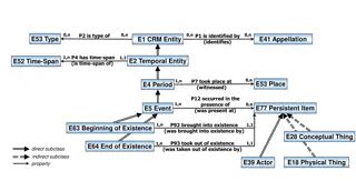
Temporal and Spatial Information Models
This content delves into the intricacies of temporal and spatial information models, covering concepts such as existence, presence, and spatiotemporal relationships. It explores how entities are identified, events are witnessed, and durations are defined within these models. The interplay between ti
6 views • 9 slides
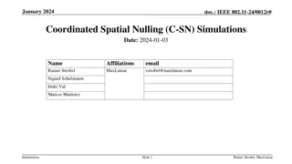
Coordinated Spatial Nulling (C-SN) Simulations in IEEE 802.11-24/0012r0
The document discusses the concept of Coordinated Spatial Nulling (C-SN) in IEEE 802.11-24/0012r0, focusing on spatial nulling feedback, synchronization needs, advantages of partial nulling, and comparison of half-coordinated versus fully coordinated scenarios. Simulation results are presented, anal
3 views • 19 slides

Enhancing Spatial Data Analysis in QGIS
Explore the integration of relational databases with QGIS to facilitate efficient spatial data analysis. Discover the importance of recognizing spatial relationships within data sets and the solutions to enhance QGIS for relational datasets. Overcome challenges and delve into the intersection and su
2 views • 25 slides
Sense Relations in Linguistics
Sense relations play a crucial role in linguistics, influencing the significance and connection between words. Various aspects such as recurrence, discrimination, lexicalizability, abstract vs. concrete relations, multiple simultaneous relations, and the entities involved characterize sense relation
1 views • 17 slides

The Four Quadrants of Public Relations
Public relations professionals engage in various relationships including internal, external, personal, and community interactions. The four quadrants of PR include Media, Community, Business, and Government relations. Each quadrant encompasses specific responsibilities and strategies such as managin
4 views • 8 slides
Semantic Relations Expressed by Prepositions in Modeling Study
Explore the study on modeling semantic relations expressed by prepositions conducted by Vivek Srikumar and Dan Roth from the University of Illinois, Urbana-Champaign. The research delves into prepositions triggering relations, ontology of preposition relations, examples of preposition relations, pre
3 views • 25 slides
Analysis of MIMO for IMMW Transmission in IEEE 802.11-24
Proposal discusses the suitability of MIMO for IMMW transmission under different scenarios. The analysis focuses on the number of spatial streams based on channel rank and quality, recommending dual-polarization for LOS paths supporting 2 spatial streams and spatial separation for larger devices sup
5 views • 16 slides
Spatial Multi-Attribute Decision Analysis with Incomplete Preference Information
In this study by Mikko Harju, Juuso Liesi, and Kai Virtanen from Aalto University, the focus is on spatial decision analysis for scenarios where decision alternatives have varying consequences across a geographical region. The research delves into the significance of spatial value functions in repre
3 views • 19 slides

Practical English Lessons on Giving Directions and Spatial Relations
Engage in interactive English learning with topics covering asking for directions, city landmarks, spatial relations, and more. Understand key phrases for seeking directions and explore a city map to navigate locations using descriptive spatial terms. Enhance your language skills with practical exer
4 views • 17 slides

ICAR KRISHI Geo-Portal: Spatial Agricultural Research Information
ICAR KRISHI Geo-Portal is a digital platform aiming to facilitate spatial agricultural data generation, compilation, visualization, and analysis. It hosts spatial databases, provides map services, and allows data sharing across platforms. The portal, developed using open-source technologies, offers
3 views • 32 slides

A Spatial Perspective
Spatial perspective is a crucial aspect in various fields, including geography, architecture, and urban planning. It involves understanding the relationships and patterns of physical spaces and their influences on human activities and environments. By adopting a spatial perspective, professionals ca
5 views • 23 slides

Discussion of COGO Spatial Data Report Card at ASPRS Rio Grande Chapter Annual Spring Meeting
The ASPRS Rio Grande Chapter Annual Spring Meeting in 2015 featured a presentation by Earl F. Burkholder on the COGO Spatial Data Report Card, evaluating the National Spatial Data Infrastructure (NSDI) framework and its management issues. The report card graded the framework on data themes and manag
2 views • 10 slides
Spatial Reuse in IEEE 802.11 - Overview and Proposal
This document explores the concept of spatial reuse in IEEE 802.11 standards, particularly focusing on the 11ax and 11be amendments. It discusses the benefits of spatial reuse, proposing enhancements for better utilization of spectrum and improved efficiency in wireless communications. The proposed
1 views • 6 slides
Australia's Foundational Spatial Data Framework Overview
Covering Australia's distributed national spatial dataset production systems and community involvement, the Foundational Spatial Data Framework (FSDF) is a government initiative aimed at streamlining the production of national spatial data products. Coordinated by Geoscience Australia, FSDF plays a
0 views • 40 slides
Spatial Microsimulation Methods for Small Area Estimation
Spatial microsimulation methods, as discussed by Dr. Paul Williamson, involve direct survey estimation, conventional small area estimation (SAE) approaches, and spatial microsimulation techniques. The process includes recalibrating survey data to meet local area constraints, such as ethnic and age d
0 views • 29 slides

Collective Spatial Keyword Queries with Inherent Cost Awareness
Spatial-textual data involving points of interest like restaurants and hotels, with a focus on Collective Spatial Keywords Queries (CoSKQ) and the introduction of a new cost function that considers both spatial distances and inherent costs of objects.
2 views • 27 slides

Geostatistical Distances Analysis in Spatial Studies
Geostatistics, a branch of statistics focusing on spatial datasets, plays a crucial role in various disciplines like geology, hydrology, and agriculture. Tobler's First Law of Geography forms the foundation of spatial analysis, emphasizing the relationship between proximity and interaction in spatia
2 views • 6 slides
Engage Your Spatial Reasoning Skills with Square Tile Placement
Enhance your spatial reasoning abilities by studying and replicating the placement of square tiles on a grid. Practice symmetry and pattern recognition to improve your spatial acuity. Utilize the provided images to test and develop your spatial understanding and design capabilities.
3 views • 12 slides
Spatial Data and Mapping Logistics for Seychelles Marine Spatial Planning Initiative
This content outlines the contributions of spatial data and mapping logistics to the Marine Spatial Planning Initiative for the Government of Seychelles. It discusses mapping questions, tools for compatibility assessment, and a draft zoning scheme with suggested zones. The focus is on identifying pr
0 views • 6 slides

Enhancing K-12 Geoscience Education with Spatial Thinking Integration
Explore a framework for integrating spatial thinking into K-12 geoscience education, focusing on improving spatial thinking, constructive geography, and spatial-temporal primitives. Discover how a place-based curriculum can enhance spatial understanding across various science disciplines.
1 views • 26 slides
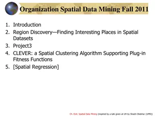
Introduction to Spatial Data Mining and Examples of Spatial Patterns
Discover the process of spatial data mining and explore examples of spatial patterns, from historic instances like Asiatic cholera in London to modern phenomena such as cancer clusters and El Nino effects.
2 views • 18 slides
IEEE 802.11-24/0888r1: Coordinated Spatial Reuse for Enhanced WLAN Performance
Explore the proposal for trigger-based spatial reuse in IEEE 802.11-24/0888r1 document dated September 2024, focusing on improving WLAN reliability, throughput, and P2P operations through coordinated spatial reuse. The document discusses modes of spatial reuse, issues with PD/PSR-based operations, a
0 views • 10 slides

Novel Trajectory Compression Framework for Road Networks
Explore a cutting-edge trajectory compression framework that efficiently reduces the burden of storing and processing spatial trajectories in road networks. This innovative approach separates spatial and temporal information, proposing lossless spatial compression algorithms, error-bounded temporal
4 views • 17 slides
Spatial Markers in Linguistic Studies: A Pilot Exploration
Explore the applicative uses of spatial markers in linguistic research conducted by PhD candidate Timofey Mukhin. The study delves into the concept of applicatives, their sources, and spatial verb morphology. Research questions examine the prevalence and characteristics of spatial markers with appli
3 views • 32 slides

Spatial Data Analysis in R: County Mapping and Operations Overview
Explore the world of spatial data analysis in R with a focus on county mapping and key operations. Learn how to work with spatial data, merge datasets, visualize maps, and perform basic spatial operations. Dive into examples and resources to enhance your spatial analysis skills.
0 views • 11 slides

Relations and Properties Overview
Explore the concepts of relations, properties, and applications, including binary relations, equivalence relations, and partial orderings. Understand how to represent relations graphically and through tables, and delve into various types of relationships in sets. Discover the different characteristi
0 views • 66 slides

Understanding Spatial Data Mining
Learn about spatial data mining, a process of uncovering interesting, useful, and unexpected spatial patterns within large databases. Discover why it is essential for gaining new insights into geographic processes and application domains, such as locating human settlements, identifying cancer cluste
2 views • 37 slides

Relations and Functions in Computer Science
Explore the theory of sets, binary relations, mappings, and various types of binary relations such as tolerance, equivalence, and partial ordering. Learn about compositions of relations and examples of binary relations. Understand the concepts of reflexivity, symmetry, transitivity in binary relatio
3 views • 18 slides

Spatial Analysis Using Python: Key Tools and Techniques
Dive into spatial analysis using Python with an overview of spatial objects, tools, examples, and case studies. Learn about Shapely for geometric operations and Geopandas for handling spatial datasets. Discover essential sources and learn how to read different file formats for spatial data analysis.
1 views • 20 slides

IEEE 802.11-25 Spatial Re-Use & Nulling Interference Cancellation Updates
Explore the latest updates in spatial re-use and spatial nulling interference cancellation requirements within the IEEE 802.11-25 standard. Gain insights into coordinated spatial re-use versus coordinated beamforming, the necessity of spatial nulling in CoBF and CoSR frames, and the flexibility in i
0 views • 8 slides