Indexing: Key Concepts and Methods
Indexing plays a crucial role in organizing and retrieving information efficiently. It simplifies data, enhances accuracy, and enables quick access. This comprehensive guide explores the concept of indexing, different methods like pre-coordinate and post-coordinate indexing, factors affecting indexi
1 views • 18 slides

Exploring the impact of automated indexing on completeness of MeSH terms
This study delves into the effects of automated indexing on the thoroughness of MeSH terms. It addresses the novelty of automated indexing, its implications for teaching, questions raised by students, observed missing index terms, and the significance of MeSH in practice. The explanation of how auto
4 views • 33 slides

Localised Adaptive Spatial-Temporal Graph Neural Network
This paper introduces the Localised Adaptive Spatial-Temporal Graph Neural Network model, focusing on the importance of spatial-temporal data modeling in graph structures. The challenges of balancing spatial and temporal dependencies for accurate inference are addressed, along with the use of distri
4 views • 19 slides

Introduction to Spatial Data Mining: Discovering Patterns in Large Datasets
Spatial data mining involves uncovering valuable patterns from extensive spatial datasets, offering insights into historical events, environmental phenomena, and predictive analytics. Examples range from analyzing disease outbreaks to predicting habitat suitability for endangered species. The applic
2 views • 20 slides
Spatial Database Systems: An Overview
This presentation by Xiaozhi Yu introduces the fundamentals of spatial database systems, covering topics such as spatial data types, relationships, system architecture, modeling, and organizing underlying spaces. It delves into the importance of integrating geometry into DBMS data models, spatial in
2 views • 30 slides
Spatial Analysis in GIS for Effective Decision-Making
Spatial analysis in GIS involves modeling geographic problems, processing data, and exploring results to understand spatial relationships, patterns, and suitability for various purposes. GIS tools offer unique capabilities for handling geographically referenced data, data entry, storage, manipulatio
3 views • 21 slides

Spatial Referencing Systems for Mapping
Spatial reference systems play a crucial role in defining geographic parameters and coordinate systems for mapping. They consist of components like orientation, latitude, longitude, and elevation, which help in representing spatial properties on maps. Reference surfaces such as the Geoid and ellipso
5 views • 13 slides

Spatial Analysis & Modeling for Spatial Planning Training in Maputo, Mozambique
Explore spatial analysis techniques for efficient route planning, site selection, pattern identification, and value prediction in the context of spatial planning. Learn about surface modeling, relationships among features, and the importance of spatial modeling in addressing geographical problems.
0 views • 27 slides

GIS Data Models for Spatial Planning Training in Maputo, Mozambique
Explore the concepts of GIS data models including vector vs. raster, spatial relationships, spatial operations, and representation of real-world entities in a spatial database. Understand how spatial data models are used to manipulate spatially-referenced information and define the spatial location
1 views • 32 slides

Efficient Office Document Management Practices
Explore the key aspects of office document management, including filing and indexing systems, classification of records, steps in the record cycle, and the functions of filing and indexing. Learn how to organize, store, retrieve, and dispose of documents effectively to ensure operational efficiency.
1 views • 26 slides
Spatial Autocorrelation in Geostatistical Analysis
Explore the concept of spatial autocorrelation, its implications in geostatistical analysis, and the importance of detecting and interpreting it correctly. Learn about auto-correlation, signal components, correlation significance, and measuring autocorrelation using tools like Moran's I. Gain insigh
1 views • 12 slides

Introduction to Information Retrieval: Compression Techniques and Index Optimization
Exploring concepts from information retrieval, this content delves into index compression methods such as blocked sort-based indexing and single-pass in-memory indexing. It discusses the importance of compression for inverted indexes to optimize memory usage and decrease disk space requirements, ult
3 views • 50 slides

Spatial Relation Switching Requirements in 3GPP NR RAN Plenary Meeting
The document discusses various spatial relation switching requirements for uplink scenarios in the 3GPP NR RAN Plenary Meeting. It covers agreement points related to UL SRS, PUCCH, P-SRS, and DL-RS, defining delay requirements and known conditions for spatial relation switching. The agreements provi
0 views • 11 slides
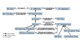
Temporal and Spatial Information Models
This content delves into the intricacies of temporal and spatial information models, covering concepts such as existence, presence, and spatiotemporal relationships. It explores how entities are identified, events are witnessed, and durations are defined within these models. The interplay between ti
4 views • 9 slides

Advanced Tools for Text Indexing and Searching in SQL and Lucene
Explore advanced techniques for text indexing and searching using SQL statements like CREATE INDEX and FULLTEXT INDEX, along with insights into popular search engines such as Lucene, Sphinx, and Thinking Sphinx. Dive into the comparison between Lucene and Sphinx, and discover how tools like Sphinx S
0 views • 13 slides
Efficient Spatial Indexing Techniques for Range Queries
Explore spatial indexing methods such as grid file, kd-tree, and quadtrees for efficient range query processing. Learn how these methods partition space, handle multidimensional points, and optimize disk access. Discover the implementation details and search strategies for exact match and range quer
1 views • 56 slides
Local Features in Computer Vision - Slides by Prof. Kristen Grauman
This collection of slides by Prof. Kristen Grauman covers topics related to indexing and matching local features in computer vision. It discusses methods for generating candidate matches, constraining matches in stereo cases, and efficiently finding relevant features in a large database. The importa
1 views • 43 slides

Text Processing: Indexing, Zipf's Law, and Vocabulary Growth
Processing text involves converting documents into index terms, addressing issues like word variations, indexing text and metadata, understanding word frequency distribution with Zipf's Law, and predicting vocabulary growth with Heaps' Law.
0 views • 30 slides
Storage and Indexing Overview in Database Management Systems
The chapter on storage and indexing covers various aspects such as data retrieval from external storage disks and tapes, file organizations like heap files and sorted files, as well as the importance and structure of indexes in speeding up data retrievals. It delves into B+ Tree indexes and their or
1 views • 33 slides

Efficient Billion-Scale Label-Constrained Reachability Queries
Graph data sets are prevalent in various domains like social networks and biological networks. Label-Constrained Reachability (LCR) queries aim to determine if a vertex can reach another vertex through specific labeled edges. Existing works utilize exhaustive search or graph indexing techniques, but
0 views • 13 slides

Efficient Data Lookup and Indexing Techniques in Systems
This content delves into advanced indexing methods for optimized data lookup in systems. It discusses linear and binary search algorithms, data structures for efficient lookups, the concept of learned indexes, and challenges to implementing learned indexes. It also introduces Bourbon, a learned inde
2 views • 16 slides

Coordinated Spatial Nulling (C-SN) Simulations in IEEE 802.11-24/0012r0
The document discusses the concept of Coordinated Spatial Nulling (C-SN) in IEEE 802.11-24/0012r0, focusing on spatial nulling feedback, synchronization needs, advantages of partial nulling, and comparison of half-coordinated versus fully coordinated scenarios. Simulation results are presented, anal
0 views • 19 slides
Advances in Full-Text Indexing Using Suffix Arrays
Explore the evolution of full-text indexing techniques leveraging suffix arrays, from SA-hash to FBCSA, with insights on experimental results, suffix trees, and compressed indexes like CSA and FM-index. Discover efficient search strategies and data structures for pattern matching in text processing.
1 views • 28 slides
Multimodal Semantic Indexing for Image Retrieval at IIIT Hyderabad
This research delves into multimodal semantic indexing methods for image retrieval, focusing on extending Latent Semantic Indexing (LSI) and probabilistic LSI to a multi-modal setting. Contributions include the refinement of graph models and partitioning algorithms to enhance image retrieval from tr
1 views • 28 slides

String Indexing and Slicing in Python
Python strings are sequences of characters that can be accessed using indexing and slicing. Indexing allows you to access individual characters in a string using numerical positions, starting from 0. Slicing enables you to extract a portion of a string by specifying a range of indices. Understanding
0 views • 26 slides

Introduction to Python Strings and Basic Operations
Python Programming introduces the string data type, representing text in programs as a sequence of characters enclosed in quotation marks. This chapter covers operations on strings using built-in functions and methods, sequences and indexing in Python strings and lists, string formatting, cryptograp
1 views • 67 slides

Mastering Array Selection and Indexing in Data Processing
Unlock the power of array selection and indexing techniques through a series of educational slides. Explore different methods for selecting elements from arrays and dive into various indexing strategies, suitable for beginners and experienced professionals alike. Gain insights into cell structures,
1 views • 70 slides

Enhancing Spatial Data Analysis in QGIS
Explore the integration of relational databases with QGIS to facilitate efficient spatial data analysis. Discover the importance of recognizing spatial relationships within data sets and the solutions to enhance QGIS for relational datasets. Overcome challenges and delve into the intersection and su
0 views • 25 slides
Overview of GeoSPARQL Implementation in Parliament
Explore the GeoSPARQL implementation in Parliament, a triple store with SPARQL support used for over a decade. Learn about its design, indexing strategy, spatial features, and missing components compared to GeoSPARQL standards. Discover how Parliament supports GML and WKT literals, various spatial r
0 views • 12 slides

ISAM Indexes and Tree-Structured Indexing Techniques
This content delves into the concepts of ISAM (Indexed Sequential Access Method) indexes and tree-structured indexing techniques used in database management. It explores the differences between ISAM and B+ trees, the implementation of sparse and dense indexes, and the structure of ISAM tree indexes.
0 views • 12 slides

Analysis of MIMO for IMMW Transmission in IEEE 802.11-24
Proposal discusses the suitability of MIMO for IMMW transmission under different scenarios. The analysis focuses on the number of spatial streams based on channel rank and quality, recommending dual-polarization for LOS paths supporting 2 spatial streams and spatial separation for larger devices sup
0 views • 16 slides
Spatial Multi-Attribute Decision Analysis with Incomplete Preference Information
In this study by Mikko Harju, Juuso Liesi, and Kai Virtanen from Aalto University, the focus is on spatial decision analysis for scenarios where decision alternatives have varying consequences across a geographical region. The research delves into the significance of spatial value functions in repre
0 views • 19 slides

Partitives and Verbal Indexing in Language
Partitives are grammatical constructions used to encode true-partitive relations, involving quantifiers and restrictors. They can also express plain quantification. Verbs may vary in indexing within partitives. Pseudo-partitives and true partitives exemplify how partitive constructions work. This st
0 views • 31 slides
ICAR KRISHI Geo-Portal: Spatial Agricultural Research Information
ICAR KRISHI Geo-Portal is a digital platform aiming to facilitate spatial agricultural data generation, compilation, visualization, and analysis. It hosts spatial databases, provides map services, and allows data sharing across platforms. The portal, developed using open-source technologies, offers
1 views • 32 slides

Semi-Indexing Semi-Structured Data in Tiny Space by Giuseppe Ottaviano and Roberto Grossi
This article discusses the concept of semi-indexing for semi-structured data in limited space, presented by Giuseppe Ottaviano and Roberto Grossi from the University of Pisa. The study explores efficient data organization techniques to optimize storage and access for structured information.
0 views • 19 slides

Spark & MongoDB Integration for LSST Workshop
Explore the use of Spark and MongoDB for processing workflows in the LSST workshop, focusing on parallelism, distribution, intermediate data handling, data management, and distribution methods. Learn about converting data formats, utilizing GeoSpark for 2D indexing, and comparing features with QServ
0 views • 22 slides
NoSQL Database Scalability Using Indexing Techniques
Dive into the world of NoSQL database scalability by understanding how indexing enables richer queries and how local indexing impacts partitioning, updates, and lookups across distributed databases.
0 views • 59 slides

String Manipulation in Java: Operations, Indexing, and Methods
The class String in Java provides operations to manipulate strings, where a string is a sequence of characters enclosed in double quotation marks. String operations include indexing, determining string length, concatenation, and various methods such as indexOf, substring, toLowerCase, and toUpperCas
0 views • 17 slides
Flexible Spatio-temporal Indexing Scheme for Large Scale GPS Tracks Retrieval
This research paper discusses a novel spatio-temporal indexing scheme optimized for managing large-scale GPS data. The study introduces a stochastic process model to simulate user behavior in uploading GPS tracks, leading to a more efficient indexing scheme with smaller size, minimal update efforts,
0 views • 24 slides
Enhancing Arabic Search and Web Visibility for Libraries
Naseej offers innovative solutions for Arabic searching, indexing, and web visibility in libraries. By focusing on high recall and precision, Naseej Smart Arabic Processor and unique indexing techniques cater to the specific needs of Arabic language handling. The integration of Library Link Network
0 views • 10 slides